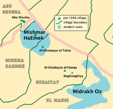
Al-Ghubayya al-Tahta
Al-Ghubayya al-Tahta was a Palestinian Arab village in the Haifa Subdistrict, located 28 km southeast of Haifa. It was depopulated during the 1947–48 Civil War in Mandatory Palestine on April 8, 1948, under the Battle of Mishmar HaEmek.
Al-Ghubayya al-Tahta الغبية التحتا | |
|---|---|
Village | |
 Al-Ghubayya al-Tahta | |
| Coordinates: 32°36′27″N 35°8′38″E | |
| Palestine grid | 163/223 |
| Geopolitical entity | Mandatory Palestine |
| Subdistrict | Haifa |
| Date of depopulation | 8–9 April 1948[1] |
| Population (1945) | |
| • Total | 1,130[2][3] |
| Cause(s) of depopulation | Military assault by Yishuv forces |
| Current Localities | Midrakh Oz[4] |
History
Al-Ghubayya al-Tahta shared an elementary school founded by the Ottomans in 1888 with the villages of al-Ghubayya-al-Fawqa and al-Naghnaghiyya. The school was closed during the British Mandate rule.
British Mandate era
In the 1922 census of Palestine, conducted by the British Mandate authorities, Ghabba al-Tahta had a population of 79 Muslims.[5] In the 1931 census, the two al-Ghubayya village were counted together, the total population was 200 Muslims, in 38 houses.[6]
In the 1945 statistics the population was counted with the neighbouring Al-Ghubayya al-Fawqa and al-Naghnaghiyya, and together they had a population of 1,130 Muslims,[2] with a total of 12,139 dunams of land according to an official land and population survey.[3] Of this, 209 dunams were for plantations and irrigable land, 10,883 for cereals,[7] while a total of 1,047 dunams were non-cultivable land.[8]
1948 and aftermath
On 8 and 9 April 1948, the Haganah raided al-Ghubayya al-Fawqa, al-Ghubayya-al-Tahta and Khirbet Beit Ras, and proceeded to blow them up in the following days.[9]
References
- Morris, 2004, p. xviii, village #151. Also gives cause of depopulation.
- Government of Palestine, Department of Statistics, 1945, p. 13
- Government of Palestine, Department of Statistics. Village Statistics, April, 1945. Quoted in Hadawi, 1970, p. 47 Archived 2016-03-03 at the Wayback Machine
- Khalidi, 1992, p. 161
- Barron, 1923, Table XI, Sub-district of Haifa, p. 33
- Mills, 1932, p. 90
- Government of Palestine, Department of Statistics. Village Statistics, April, 1945. Quoted in Hadawi, 1970, p. 90
- Government of Palestine, Department of Statistics. Village Statistics, April, 1945. Quoted in Hadawi, 1970, p. 139 Archived 2015-09-24 at the Wayback Machine
- Morris, 2004, p. 242; note #598; Morris, 2004, p. 296
Bibliography
- Barron, J.B., ed. (1923). Palestine: Report and General Abstracts of the Census of 1922. Government of Palestine.
- Government of Palestine, Department of Statistics (1945). Village Statistics, April, 1945.
- Hadawi, S. (1970). Village Statistics of 1945: A Classification of Land and Area ownership in Palestine. Palestine Liberation Organization Research Center. Archived from the original on 2018-12-08. Retrieved 2009-08-18.
- Khalidi, W. (1992). All That Remains: The Palestinian Villages Occupied and Depopulated by Israel in 1948. Washington D.C.: Institute for Palestine Studies. ISBN 0-88728-224-5.
- Mills, E., ed. (1932). Census of Palestine 1931. Population of Villages, Towns and Administrative Areas. Jerusalem: Government of Palestine.
- Morris, B. (2004). The Birth of the Palestinian Refugee Problem Revisited. Cambridge University Press. ISBN 978-0-521-00967-6.
- al-Qawuqji, F. (1972): Memoirs of al-Qawuqji, Fauzi in Journal of Palestine Studies
- "Memoirs, 1948, Part I" in 1, no. 4 (Sum. 72): 27-58., dpf-file, downloadable
- "Memoirs, 1948, Part II" in 2, no. 1 (Aut. 72): 3-33., dpf-file, downloadable
External links
- Welcome To al-Ghubayya al-Tahta
- al-Ghubayya al-Tahta, Zochrot
- Survey of Western Palestine, Map 8: IAA, Wikimedia commons
- al-Ghubayya al-Tahta from the Khalil Sakakini Cultural Center
- Al-Ghubayya Al-Tahta from Dr. Moslih Kanaaneh
- Tour to the al-Ghubayyat villages, by Umar Ighbariyye, 20.3.2010, Zochrot