Abu Shusha, Haifa
Abu Shusha (Arabic: أبو شوشة) was a Palestinian Arab village in the Haifa Subdistrict. It was depopulated during the 1947–48 Civil War in Mandatory Palestine on 9 April 1948 during the Battle of Mishmar HaEmek.
Abu Shusha أبو شوشة | |
|---|---|
Village | |
 Children of Abu Shusha, before the Nakba | |
| Etymology: The father of the Tuft[1] | |
 Abu Shusha | |
| Coordinates: 32°36′51″N 35°08′17″E | |
| Palestine grid | 163/224 |
| Geopolitical entity | Mandatory Palestine |
| Subdistrict | Haifa |
| Date of depopulation | 9–10 April 1948[2] |
| Area | |
| • Total | 8,960 dunams (9 km2 or 3 sq mi) |
| Population (1948) | |
| • Total | 835 |
| Cause(s) of depopulation | Military assault by Yishuv forces |
| Current Localities | Mishmar HaEmek |
History
The village was located just west of Tel Shush, which recent examination shows may date from the Early Bronze Age.[3] It has also been suggested as the location of the Roman town of Gaba Hippeon, founded in the year 61 BCE, by the Roman governor of Syria, L. Marcius Philippus.[4][5][6] It was an episcopal see in the fifth-sixth centuries,[6] and ceramics from the Byzantine era have been found here.[7]
Ottoman era
In 1870 Victor Guérin described it as a small village. The slopes of the hill were covered with many piles of overturned materials from buildings, and on the highest point was the remains of an old tower.[8]
In 1882, the PEF's Survey of Western Palestine (SWP) described "a little hamlet on the edge of the plain, with a spring to the east."[9]
British Mandate era
In the British Mandate of Palestine period, in the 1922 census of Palestine Abu Shusheh had a population of 12; all Muslims,[10] increasing sharply in the 1931 census when it was counted with Esh Shuqeirat and Arab el Saayda, to 831; still all Muslim, in a total of 155 houses.[11]
In 1926 a small group of Jews from the Hashomer Hatzair movement settled in a caravanserai located on Tell Abu Shusha, before they moved to a location a few hundred yards south[12] and established Mishmar HaEmek.[13]
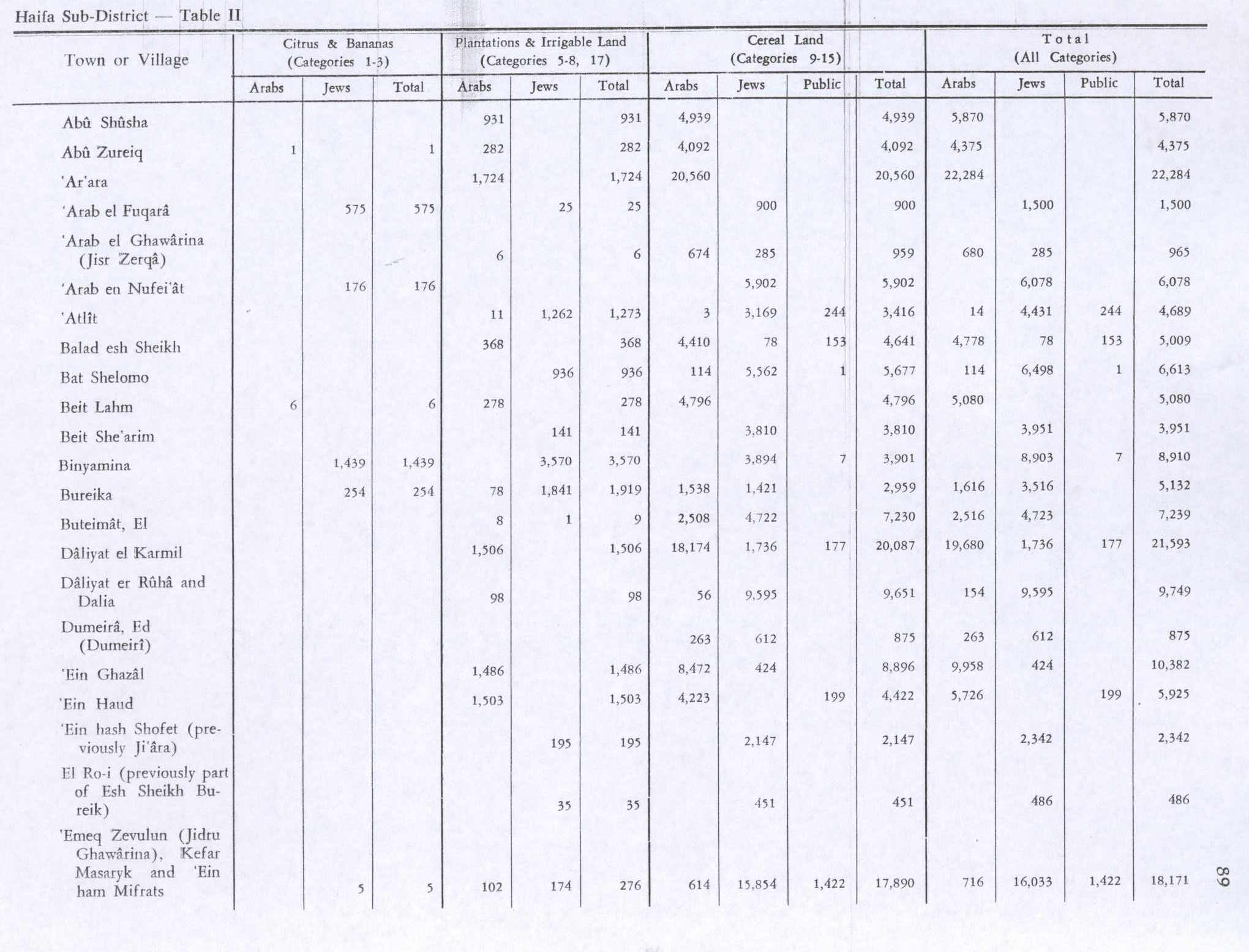
In the 1945 statistics Abu Shusha had a population of 720, all Muslims,[14] with a total of 8,960 dunams of land.[15] Of this, 931 dunums were plantations or irrigable land, 4,939 were for cereals,[16] while 3,090 dunams were classified as uncultivable land.[17]
In 1940s a resident called Salim Ibn Hussein moved to Syria and returned in 1947, infused with Arab nationalism and led the armed guard of Abu Shusha during the 1947–1948 Civil War in Mandatory Palestine.[18]
1948, aftermath
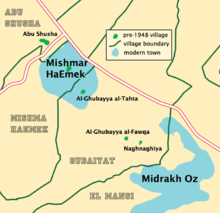
On 5 April 1948 after ALA launched the attack[19] and Abu Shusha among other villages served as a base to attacks on Mishmar HaEmek[20] , the Haganah General Staff (HGS) instructed the Golani Brigade: "You must tell the following villages ... that we cannot assure their safety and security, and that they must evacuate forthwith." Among the four villages were Abu Shusha, Daliyat al-Rawha' and Al-Rihaniyya.[19][21] According to Ben-Gurion, a delegation of Mishmar HaEmek leaders came to him on the 8th or 9 April, and told him that "it was imperative to expel the Arabs [in the area] and to burn the villages."[19][22]
By the 11 April, the village was empty, and 1 Battalion in the Palmach blew up 30 houses in Al-Kafrayn and Abu Shusha in order to block the return of the villagers.[23][24] Following the 1948 war, the area was incorporated into the State of Israel.
In 1992, Walid Khalidi described the area: "The only remaining sign of the village is the debris of houses, overgrown with cactuses. The grain mill is gone. On the hilly lands around the site, olive trees grow in a fenced-in area that serves as a pasture. The adjacent lands in Marj ibn Amir are planted in various crops, especially cotton."[25]
Two village histories have been written about Abu Shusha and the Arab Turkoman; one in 1987 by Alya Khatib,[26] and one in 1999 by Faisal al-Shuqayrat.[27]
References
- Palmer, 1881, p. 142
- Morris, 2004, p. xviii, village #152. Also gives cause of depopulation.
- Khalidi, 1992, p. 142
- Siegelman, 1984, cited in Khalidi, 1992, p. 142
- Shatzman, 1991, p. 258
- Tsafrir, di Segni and Green, 1994, p. 126
- Dauphin, 1998, pp. 700–701
- Guérin, 1875, pp. 239-240
- Conder and Kitchener, 1882, SWP II, p. 41
- Barron, 1923, Table XI, Sub-district of Haifa, p. 33
- Mills, 1932, p. 87
- Morris, 1987, pp.116, 117
- "משמר העמק – אירועים מרכזיים בהיסטוריית משמר העמק [Mishmar HaEmek – Key events in the history of Mishmar HaEmek]". Mishmar HaEmek website (in Hebrew). Retrieved 8 July 2016.
- Government of Palestine, Department of Statistics, 1945, p. 13
- Government of Palestine, Department of Statistics. Village Statistics, April, 1945. Quoted in Hadawi, 1970, p. 47 Archived 2016-03-03 at the Wayback Machine
- Government of Palestine, Department of Statistics. Village Statistics, April, 1945. Quoted in Hadawi, 1970, p. 89
- Government of Palestine, Department of Statistics. Village Statistics, April, 1945. Quoted in Hadawi, 1970, p. 139
- Ozev, Amriam (2013). "chapter i". Mishmar HaEmek Will Stand (in Hebrew). Kinneret, Zmora-Bitan, Dvir. ISBN 978-965-552-557-1. Retrieved 29 July 2016.
- Morris, 2004, p. 241
- Troen, S. Ilan; Lucas, Noah (2012-02-01). Israel: The First Decade of Independence. SUNY Press. ISBN 978-1-4384-2232-9.
- Morris, 2004, p. 296: Note #594
- Morris, 2004, p. 296: Note #593
- Morris, 2004, p. 346
- Morris, 2004, p. 397, note 30
- Khalidi, 1992, p. 143
- Davis, 2011, p. 283
- Davis, 2011, p. 285
Bibliography
- Barron, J.B., ed. (1923). Palestine: Report and General Abstracts of the Census of 1922. Government of Palestine.
- Conder, C.R.; Kitchener, H.H. (1882). The Survey of Western Palestine: Memoirs of the Topography, Orography, Hydrography, and Archaeology. 2. London: Committee of the Palestine Exploration Fund.
- Dauphin, Claudine (1998). La Palestine byzantine, Peuplement et Populations. BAR International Series 726 (in French). III : Catalogue. Oxford: Archeopress. ISBN 0-86054-905-4.
- Davis, Rochelle (2011). Palestinian Village Histories: Geographies of the Displaced. Stanford: Stanford University Press. ISBN 978-0-8047-7313-3. (p. XXV)
- Flapan, S. "The Palestinian Exodus of 1948" in 16, no. 4 (Sum. 87): 3–26. Simha Flapan records HaShomer HaTzair member Eliezer Bauer, who was also a member of the Mapam Arab Department reporting during a discussion that the villagers of Abu Zrik and Abu Shusha were arrested or driven out and the villages were then destroyed.
- Government of Palestine, Department of Statistics (1945). Village Statistics, April, 1945.
- Guérin, V. (1875). Description Géographique Historique et Archéologique de la Palestine (in French). 2: Samarie, pt. 2. Paris: L'Imprimerie Nationale.
- Hadawi, S. (1970). Village Statistics of 1945: A Classification of Land and Area ownership in Palestine. Palestine Liberation Organization Research Center. Archived from the original on 2018-12-08. Retrieved 2009-08-18.
- Khalidi, W. (1992). All That Remains: The Palestinian Villages Occupied and Depopulated by Israel in 1948. Washington D.C.: Institute for Palestine Studies. ISBN 0-88728-224-5.
- Mills, E., ed. (1932). Census of Palestine 1931. Population of Villages, Towns and Administrative Areas. Jerusalem: Government of Palestine.
- Morris, B. (1987). The Birth of the Palestinian refugee problem, 1947–1949. Cambridge University Press. ISBN 0-521-33028-9.
- Morris, B. (2004). The Birth of the Palestinian Refugee Problem Revisited. Cambridge University Press. ISBN 978-0-521-00967-6.
- Palmer, E.H. (1881). The Survey of Western Palestine: Arabic and English Name Lists Collected During the Survey by Lieutenants Conder and Kitchener, R. E. Transliterated and Explained by E.H. Palmer. Committee of the Palestine Exploration Fund.
- Siegelmann, A. (1984). "The Identification of Gaba Hippeon". Palestine Exploration Quarterly. 116: 89–93.
- Shatzman, Israel (1991). The Armies of the Hasmonaeans and Herod: From Hellenistic to Roman Frameworks. Mohr Siebeck.
- Tsafrir, Y.; Leah Di Segni; Judith Green (1994). (TIR): Tabula Imperii Romani: Judaea, Palaestina. Jerusalem: Israel Academy of Sciences and Humanities. ISBN 965-208-107 8.
External links
- Welcome To Abu Shusha
- Abu Shusha (Haifa), Zochrot
- Survey of Western Palestine, Map 8: IAA, Wikimedia commons
- Abu Shusha from the Khalil Sakakini Cultural Center
- Abu Shusha – District of Haifa, dr Khalidi