Al-Burayj
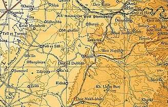
Al-Burayj was a Palestinian Arab village in the Jerusalem Subdistrict. It was depopulated during the 1948 Arab–Israeli War on October 19, 1948, during the first phase of Operation Ha-Har. The village was located 28.5 km west of Jerusalem.
Al-Burayj البريج' | |
|---|---|
| Etymology: The little tower[1] | |
 Al-Burayj | |
| Coordinates: 31°44′20″N 34°55′44″E | |
| Palestine grid | 143/127 |
| Geopolitical entity | Mandatory Palestine |
| Subdistrict | Jerusalem |
| Date of depopulation | Not known[2] |
| Area | |
| • Total | 19,080 dunams (19.08 km2 or 7.37 sq mi) |
| Population (1945) | |
| • Total | 720[4][3] |
| Current Localities | Sdot Micha[5]Sdot Micha Airbase[5] |
History
In 1838 el-Bureij was noted as a Muslim village, located in er-Ramleh district.[6]
In 1863 Victor Guérin noted it as a village of 200 inhabitants. The Sheikh's house was described as "fairly large and fairly constructed"; the others, less so. Tobacco plantations were spread around. He also noted large ancient blocks, which, it was said, originated from Kh. Tibneh, just to the north.[7]
Socin found from an official Ottoman village list from about 1870 that buredsch had a population of 116 in a total of 41 houses, though that population count included men, only. It was further noted that it was located between Mughallis and Saydun.[8] Hartmann found that el buredsch had 40 houses.[9]
In 1882, the PEF's Survey of Western Palestine (SWP) described El Bureij as: "A small village on high ground, having a high house or tower in the middle, from which it is named."[10]
British Mandate era
In the 1922 census of Palestine conducted by the British Mandate authorities, Buraij had a population of 398; all Muslims,[11] increasing in the 1931 census to 621; 7 Christians and 614 Muslims, in a total of 132 houses.[12]
In the 1945 statistics, the village had a population of 720; 10 Christians and 710 Muslims,[4] with a total of 19,080 dunums of land.[3] Of this, 31 dunams were for citrus and bananas, 77 were for irrigable land or plantations, 9,426 for cereals,[13] while 14 dunams were built-up (urban) Arab land.[14]
al-Burayj had a mosque named al-'Umari mosque and a Greek Orthodox Monastery.[15]

1948, aftermath
During Operation Ha-Har, between the 19 and 24 October 1948, the Harel Brigade captured several villages, among them Bureij. The villagers fled, or were expelled eastwards.[16]
Following the war, the area was incorporated into the State of Israel. In 1955 the moshav of Sdot Micha was established on land that had belonged to al-Burayj, south of the village site.[5]
 Monastery building at Al-Burayj after capture by Harel Brigade
 Prisoners waiting to be interrogated, Al-Burayj, 1948
 Al-Burayj 1948
 Members of Harel Brigade in Al-Burayj 1948
Large part of the village land is now a military base called Sdot Micha Airbase, which is inaccessible to the public.[5]
References
- Palmer, 1881, p. 267
- Morris, 2004, p. xix, village #272. Gives both cause and date of depopulation as "Not known"
- Government of Palestine, Department of Statistics. Village Statistics, April, 1945. Quoted in Hadawi, 1970, p. 56 Archived 2008-08-05 at the Library of Congress Web Archives
- Department of Statistics, 1945, p. 24
- Khalidi, 1991, p. 282
- Robinson and Smith, 1841, vol 3, Appendix 2, p. 120
- Guérin, 1869, p. 30
- Socin, 1879, p. 149
- Hartmann, 1883, p. 140
- Conder and Kitchener, 1882, SWP II, p. 8
- Barron, 1923, Table VII, Sub-district of Ramleh, p. 21
- Mills, 1932, p. 19
- Government of Palestine, Department of Statistics. Village Statistics, April, 1945. Quoted in Hadawi, 1970, p. 102
- Government of Palestine, Department of Statistics. Village Statistics, April, 1945. Quoted in Hadawi, 1970, p. 152
- Khalidi, 1991, pp. 281-282
- Morris, 2004, p. 466
Bibliography
- Barron, J. B., ed. (1923). Palestine: Report and General Abstracts of the Census of 1922. Government of Palestine.
- Conder, C.R.; Kitchener, H.H. (1882). The Survey of Western Palestine: Memoirs of the Topography, Orography, Hydrography, and Archaeology. 2. London: Committee of the Palestine Exploration Fund.
- Department of Statistics (1945). Village Statistics, April, 1945. Government of Palestine.
- Guérin, V. (1869). Description Géographique Historique et Archéologique de la Palestine (in French). 1: Judee, pt. 2. Paris: L'Imprimerie Nationale.
- Hadawi, S. (1970). Village Statistics of 1945: A Classification of Land and Area ownership in Palestine. Palestine Liberation Organization Research Centre. Archived from the original on 2018-12-08. Retrieved 2009-08-18.
- Hartmann, M. (1883). "Die Ortschaftenliste des Liwa Jerusalem in dem türkischen Staatskalender für Syrien auf das Jahr 1288 der Flucht (1871)". Zeitschrift des Deutschen Palästina-Vereins. 6: 102–149.
- Khalidi, W. (1992). All That Remains: The Palestinian Villages Occupied and Depopulated by Israel in 1948. Washington D.C.: Institute for Palestine Studies. ISBN 0-88728-224-5.
- Mills, E., ed. (1932). Census of Palestine 1931. Population of Villages, Towns and Administrative Areas. Jerusalem: Government of Palestine.
- Morris, B. (2004). The Birth of the Palestinian Refugee Problem Revisited. Cambridge University Press. ISBN 978-0-521-00967-6.
- Palmer, E. H. (1881). The Survey of Western Palestine: Arabic and English Name Lists Collected During the Survey by Lieutenants Conder and Kitchener, R. E. Transliterated and Explained by E.H. Palmer. Committee of the Palestine Exploration Fund.
- Robinson, E.; Smith, E. (1841). Biblical Researches in Palestine, Mount Sinai and Arabia Petraea: A Journal of Travels in the year 1838. 3. Boston: Crocker & Brewster.
- Socin, A. (1879). "Alphabetisches Verzeichniss von Ortschaften des Paschalik Jerusalem". Zeitschrift des Deutschen Palästina-Vereins. 2: 135–163.
External links
- Welcome To al-Burayj
- al-Burayj, Zochrot
- Survey of Western Palestine, Map 16: IAA, Wikimedia commons
- Al-Burayi, from the Khalil Sakakini Cultural Center