Sankh River
The Sankh River flows across Jharkhand, Chhattisgarh and Odisha states in India. The river flows for 240 kilometres (150 mi) before it meets the Koel River in Odisha.
| Sankh River | |
|---|---|
 Sankh River | |
| Native name | ଶଙ୍ଖ ନଦୀ |
| Location | |
| Country | India |
| State | Jharkhand, Chhattisgarh, Odisha |
| Physical characteristics | |
| Source | Lupungpat village |
| ⁃ location | Gumla district, Jharkhand |
| ⁃ coordinates | 23°14′N 84°16′E |
| ⁃ elevation | 1,000 m (3,300 ft) |
| Mouth | Confluence with Koel River to form Brahmani River |
| Length | 240 km (150 mi) |
Course
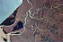
The river starts 1,000 metres (3,300 ft) above sea level in Lupungpat village in Gumla district in Jharkhand and flows 67.5 kilometres (41.9 mi) in the state before entering Chhattisgarh. It runs a distance of about 50 kilometres (31 mi) in Chhattisgarh and enters Jharkhand again to flow for another 78 kilometres (48 mi). The river finally enters Odisha and travels another 45 kilometres (28 mi) before merging with the Koel.[1] The South Koel enters Odisha and joins the Sarnkh River at Vedavyas near Rourkela from where it is called the Brahmani (see 22°14′45″N 84°47′02″E).[2]
Sadni Falls
The 60-metre (200 ft) high Sadni Falls on the Sankh River at the edge of the Ranchi plateau is an example of scarp falls or knick line falls.[3]
References
- Hydrology and Water Resources of India by Sharad K. Jain, Pushpendra K. Agarwal, Vijay P
- "Initiatives & Activities IRN-ORISSA". IRN – Kerala. Retrieved 20 April 2010.
- K. Bharatdwaj (2008). Physical Geography: Hydrosphere. Discovery Publishing Pvt. Ltd. p. 161. ISBN 9788183561679.