Jashpur district
Jashpur District lies in the north-eastern corner of the state of Chhattisgarh in India adjoining the border of Jharkhand and Odisha. Jashpur Nagar is the administrative headquarters of the district. It is placed among valleys and surrounded with lush green environment. Jashpur has a rich historical culture. It was a princely state before independence. The density of the population is 132 persons per sq. km. 91% of the population is rural where as 9% belongs to the urban populace. The district is tribal-populated where 62.28%. The district is famous and rich for its tribal inherent culture where 14608 are Pahadi Korvas, a primitive vulnerable tribal group and 515 are the Birhor tribes.
Jashpur district | |
|---|---|
District of Chhattisgarh | |
 | |
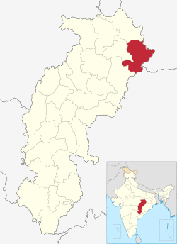 Location of Jashpur district in Chhattisgarh | |
| Country | India |
| State | Chhattisgarh |
| Headquarters | Jashpur Nagar |
| Tehsils | 8 |
| Government | |
| • District Collector and Magistrate | Nileshkumar Mahadev Kshirsagar |
| • Lok Sabha constituencies | 1 |
| • Vidhan Sabha constituencies | 3
Kunkuri Jashpur Pathalgaon |
| Area | |
| • Total | 5,838 km2 (2,254 sq mi) |
| Population (2011) | |
| • Total | 851,669 |
| • Density | 150/km2 (380/sq mi) |
| Demographics | |
| • Literacy | 82% |
| • Sex ratio | 1000:1004 |
| Time zone | UTC+05:30 (IST) |
| Major highways | 1(NH-43) |
| Average annual precipitation | 1400 mm |
| Website | jashpur |
Shri Nileshkumar Mahadev Kshirsagar is the District Collector and Magistrate of Jashpur. He has previously served as MD to National Rural Livelihood Mission, Government of Chhattisgarh and CEO Zila Panchayat Raipur.[1]
History
During the British Raj Jashpur town was the capital of Jashpur State, one of the princely states of the Eastern States Agency.[2] During the British Raj, Jashpur town was the capital of Jashpur State, one of the princely states of the Eastern States Agency.[1] Merged with Independent India in 1948 the last king before Independence was Vijay Bhushan Singh Ju Deo. .
Geography
The north-south length of this district is about 150 km, and its east-west breadth is about 85 km. Its total area is 6,205 km². It is between 22° 17′ and 23° 15′ North latitude and 83° 30′ and 84° 24′ East longitude. Geographical area 6701 Km2
It is divided geographically into two parts. The northern hilly belt is called the Upper Ghat. The remaining, southern part, is called Nichghat.
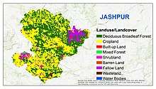
The upper ghat runs from Loroghat Kastura, Narayanpur, Bagicha up to the Surguja district. This belt is a forest area and contains a reserve forest. It covers Sanna, Bagicha, and Narayanpur. The upper ghat is an extension plateau covering 1384 km² which is about 1200 meters above sea level and is covered by a dense forest. The elevated plateau is called "Pat". The Upper Ghat is climbed through Loroghat. Loroghat is about 4 km in length and there are three turnings that are very dangerous.
Nichghat is flat in general but also has many big mountains. In Jashpur Raigarh road there are two more ghats, both climbing, Jhanda ghat before Kansabel and Belaghat after Kansabel.
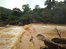
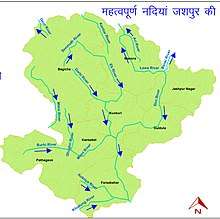
Major rivers in the Mahanadi basin are Ib and its tributaries such as Dorki, Maini, Kokiya, Utai, Khadung, and Burhi. In the eastern part, rivers named Girma and Lava Nadi flow in the Brahmani basin. Lower Ganges part is mainly drained by Geor and Kanhar rivers. The drainage pattern is dendritic and is highly irregular, which is reflective of the topography. Irregular topography results in huge base flow through the streams and less recharge.
Towns
The main towns situated on the national highway (N.H.78) are Lodam, Gholeng, and Jashpur in the Upper ghat and Kunkuri, Bandarchuwan, Kansabel, Ludeg, and Patthalgaon. The roads running from Jashpur H.Q are:
- Jashpur Ranchi.
- Jashpur Ambikapur via Manora, Kusmi (170).
- Jashpur Ambikapur via Sanna Bagicha (170 km). These 2 and 3 are not the all-weather road.
- Jashpur Ambikapur via Kunkuri, Patthalgaon (200 km).
- Jashpur Ambikapur via Nrayanpur Baghicha.
Climate
Kunkuri is the hottest region in Nichghat during the summer and Pandrapat is the coldest region in Upper Ghat in the winter. It is situated between forests. It is a junction, from Raigarh and from Ambikapur or Jashpur all the people need to cross Patthalgaon first.
Weather record |location = Jashpur District (1998–2015)
| Weather Data | JAN | FEB | MAR | APR | MAY | JUN | JULY | AUG | SEPT | OCT | NOV | DEC | Annual |
|---|---|---|---|---|---|---|---|---|---|---|---|---|---|
| Max Temperature (°C) | 31.20 | 35.19 | 39.13 | 42.87 | 43.74 | 44.0 | 36.77 | 33.50 | 34.29 | 33.56 | 32.80 | 30.25 | 36.45 |
| Min Temperature (°C) | 1.18 | 5.83 | 8.77 | 16.01 | 19.13 | 20.67 | 20.48 | 21.01 | 19.48 | 13.2 | 8.15 | 5.66 | 13.33 |
| Rainfall(mm) | 19.23 | 16.25 | 20.42 | 19.87 | 36.50 | 191.1 | 389.62 | 380.44 | 236.83 | 75.85 | 7.23 | 6.77 | 1400.173 |
Soil
Yellow soils (Ultisols) and red soils (Alfisols) developed over the granitoids occupy most part of the district Black soils (Inceptisols) have formed over the deccan traps in small patches
Geology and Hydrology
Most part of the District is covered by granitoids. A small portion in the northwestern part is occupied by the Deccan Traps and Lametas. Almost the entire area has a thick laterite cover. Nearly 90% of the area in the district is covered with granitoids, which include granite gneiss, chlorite-biotite gneiss, muscovite granite, granodiorite etc. Remaining area is occupied by Deccan Traps and Lametas. The entire has a thick carapace of laterite. Thickness of laterite cover varies from a few metres to more than 30m. at several places. Broadly the area can be divided into 4 hydro-stratigraphic units viz. Laterite, Granitoids, Deccan Traps and Lametas.
Geomorphology
i) Major Physiographic Units- The northern hilly areas can be categorised as structural hills and the relatively plain areas in the southern part can be categorised as pediplains. ii) Major Drainages- Mahanadi basin occupies nearly 71% area in the central part, Bramhani basin covers 21% area in the eastern part and Lower Ganges basin spreads over an area of 8% in the northern part of the district.
Demographics
According to the 2011 census Jashpur district has a population of 851,669,[3] roughly equal to the nation of Qatar[4] or the US state of South Dakota.[5] This gives it a ranking of 473rd in India (out of a total of 640).[3] The district has a population density of 146 inhabitants per square kilometre (380/sq mi).[3] Its population growth rate over the decade 2001-2011 was 14.65%.[3] Jashpur has a sex ratio of 1004 females for every 1000 males,[3] and a literacy rate of 68.6%.[3]
At the time of the 2011 Census of India, 66.07% of the population in the district spoke Hindi, 27.57% Kurukh, 5.11% Odia and 0.44% Kharia as their first language.[6]
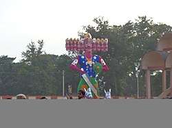
Tour and Place
References
- http://jashpur.gov.in
- Malleson, G. B.: An historical sketch of the native states of India, London 1875, Reprint Delhi 1984
- "District Census 2011". Census2011.co.in. 2011. Retrieved 2011-09-30.
- US Directorate of Intelligence. "Country Comparison:Population". Retrieved 2011-10-01.
Qatar 848,016 July 2011 est.
- "2010 Resident Population Data". U. S. Census Bureau. Archived from the original on 2013-10-19. Retrieved 2011-09-30.
South Dakota 814,180
- 2011 Census of India, Population By Mother Tongue
  7. GOVT. Of INDIA Ministry Of Water Resources Central Ground Water Board
  8. One of the important information page in facebook about jashpur. https://www.facebook.com/JashpurNagarcg/
External links
Places adjacent to Jashpur district | ||||||||||
|---|---|---|---|---|---|---|---|---|---|---|
| ||||||||||
Capital: Raipur (Current) Naya Raipur (Future) | ||
| Governance |
|  |
| Topics | ||
| Divisions |
| |
| Districts | ||
| Cities | ||
| ||