Sillanwali
Sillanwali (Punjabi, Urdu: سِلانٚوالى) is a town of Sargodha District in the Punjab province of Pakistan. The town is tehsil headquarters of Sillanwali Tehsil.[2] Located 37 km (23 mi) away from Sargodha city, it lies in the southern area of Sargodha District.[3]
Sillanwali سِلانٚوالى | |
|---|---|
City | |
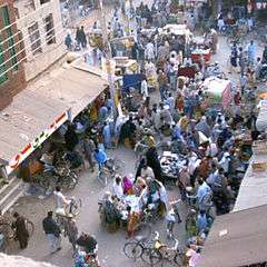 Aerial view of the Main Bazaar at Sillanwali | |
 Sillanwali | |
| Coordinates: 31°49′30″N 72°32′20″E | |
| Country | |
| Elevation | 173 m (568 ft) |
| Population | |
| • Total | 37,776 |
| Time zone | UTC+5 (PST) |
| Calling code | 0992 |
History
The town developed in the late 19th century during the rule of the British empire. It was planned to be an agricultural business hub or mandi ("wholesale market").
It was a planned town, developed after canals were built for agricultural purposes and a railway line was established. Even today, the railway station at Sillanwali is known as "Sillanwali Mandi" in railway records. Before the Partition of India in 1947, Sillanwali was well known for the production of cotton. Most of the population were Hindu Khatris. After partition the Hindus migrated to India and their property was taken over by the Muslim Sheikhs (having Khatri Origin), most of whom had migrated from Karnal District of Haryana state which had been part of united Punjab but became part of Indian Punjab after 1947.
At the same time, Jat Sikhs migrated to India, and members of the Rajput, Arain, Khokhar, Sheikh, Gujjar, Jatt Muslims, Dogar and Rehmani moved to Silanwali and the surrounding villages.
References
Neighbourhoods of Sargodha | ||
|---|---|---|
Administrations: Sargodha Division and Sargodha District | ||
| Tehsils | 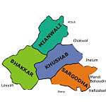 | |
| Cities |
| |
| Towns & councils | ||
| Localities |
| |
Website: Sargodha District at NRB | ||