Temelec, California
Temelec is a census-designated place (CDP) in Sonoma County, California, United States. The population was 1,441 at the 2010 census.
Temelec | |
|---|---|
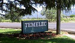 The north entrance sign for the Temelec housing development, at the corner of Almeria and Arnold | |
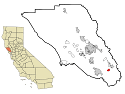 Location in Sonoma County and the state of California | |
| Coordinates: 38°16′0″N 122°29′34″W | |
| Country | |
| State | |
| County | Sonoma |
| Area | |
| • Total | 1.588 sq mi (4.113 km2) |
| • Land | 1.588 sq mi (4.113 km2) |
| • Water | 0 sq mi (0 km2) 0% |
| Elevation | 98 ft (30 m) |
| Population (2010) | |
| • Total | 1,441 |
| • Density | 910/sq mi (350/km2) |
| Time zone | UTC-8 (PST) |
| • Summer (DST) | UTC-7 (PDT) |
| ZIP code | 95476 |
| Area code(s) | 707 |
| FIPS code | 06-78126 |
| GNIS feature ID | 1799782 |
| Reference no. | 237 |
Temelec Hall
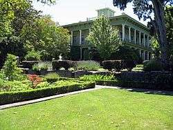
Temelec is the site of Temelec Hall, built in 1858 by Captain Granville P. Swift, a member of the Bear Flag Party. The hall was owned by journalist Edmond Coblentz in the mid 1900s.[3] The hall is currently part of the Temelec Adult Community Center. Located at 220 Temelec Circle, it was designated California Historical Landmark #237.
Geography
According to the United States Census Bureau, the CDP has a total area of 1.6 square miles (4.1 km2), all land.
Demographics
2010
At the 2010 census Temelec had a population of 1,441. The population density was 907.4 people per square mile (350.3/km²). The racial makeup of Temelec was 1,376 (95.5%) White, 4 (0.3%) African American, 4 (0.3%) Native American, 31 (2.2%) Asian, 5 (0.3%) Pacific Islander, 5 (0.3%) from other races, and 16 (1.1%) from two or more races. Hispanic or Latino of any race were 68 people (4.7%).[4]
The census reported that 100% of the population lived in households.
There were 960 households, 8 (0.8%) had children under the age of 18 living in them, 318 (33.1%) were opposite-sex married couples living together, 45 (4.7%) had a female householder with no husband present, 12 (1.3%) had a male householder with no wife present. There were 30 (3.1%) unmarried opposite-sex partnerships, and 22 (2.3%) same-sex married couples or partnerships. 513 households (53.4%) were one person and 398 (41.5%) had someone living alone who was 65 or older. The average household size was 1.50. There were 375 families (39.1% of households); the average family size was 2.07.
The age distribution was 11 people (0.8%) under the age of 18, 4 people (0.3%) aged 18 to 24, 23 people (1.6%) aged 25 to 44, 411 people (28.5%) aged 45 to 64, and 992 people (68.8%) who were 65 or older. The median age was 71.5 years. For every 100 females, there were 63.9 males. For every 100 females age 18 and over, there were 63.6 males.
There were 1,051 housing units at an average density of 661.8 per square mile (255.5/km²), of which 86.7% were owner-occupied and 13.3% were occupied by renters. The homeowner vacancy rate was 3.9%; the rental vacancy rate was 6.5%. 87.2% of the population lived in owner-occupied housing units and 12.8% lived in rental housing units.
2000
At the 2000 census there were 1,556 people, 989 households, and 452 families in the CDP. The population density was 919.0 per square mile (355.5/km²). There were 1,045 housing units at an average density of 617.2 per square mile (238.7/km²). The racial makeup of the CDP was 96.53% White, 0.06% African American, 0.39% Native American, 1.74% Asian, 0.13% Pacific Islander, 0.13% from other races, and 1.03% from two or more races. Hispanic or Latino of any race were 2.63%.[5]
Of the 989 households 0.1% had children under the age of 18 living with them, 41.8% were married couples living together, 3.7% had a female householder with no husband present, and 54.2% were non-families. 47.1% of households were one person and 37.3% were one person aged 65 or older. The average household size was 1.56 and the average family size was 2.07.
The age distribution was 0.2% under the age of 18, 0.4% from 18 to 24, 2.6% from 25 to 44, 22.6% from 45 to 64, and 74.3% 65 or older. The median age was 73 years. For every 100 females, there were 66.8 males. For every 100 females age 18 and over, there were 66.6 males.
The median household income was $36,964 and the median family income was $49,766. Males had a median income of $45,781 versus $38,889 for females. The per capita income for the CDP was $33,678. About 1.8% of families and 3.5% of the population were below the poverty line, including none of those under age 18 and 2.1% of those age 65 or over.
Politics
In the state legislature, Temelec is located in the 3rd Senate District, and in the 6th Assembly District.
Federally, Temelec is in California's 5th congressional district, represented by Democrat Mike Thompson.[6]
References
- U.S. Census Archived 2012-07-02 at the Wayback Machine
- U.S. Geological Survey Geographic Names Information System: Temelec
- "2010 Census Interactive Population Search: CA - Temelec CDP". U.S. Census Bureau. Archived from the original on July 15, 2014. Retrieved July 12, 2014.
- "U.S. Census website". United States Census Bureau. Retrieved 2008-01-31.
- "California's 5th Congressional District - Representatives & District Map". Civic Impulse, LLC. Retrieved March 3, 2013.
See also
Municipalities and communities of Sonoma County, California, United States | ||
|---|---|---|
| Cities and towns |  Sonoma County map | |
| CDPs |
| |
| Unincorporated communities | ||
| Indian reservations | ||
| Bodies of water |
|  |
|---|---|---|
| Counties | ||
| Major cities | ||
| Cities and towns 100k–250k | ||
| Cities and towns 50k–99k | ||
| Cities and towns 25k–50k | ||
| Cities and towns 10k–25k |
| |
| Sub-regions | ||