New Mexico statistical areas
The statistical areas of the United States of America comprise the metropolitan statistical areas (MSAs),[1] the micropolitan statistical areas (μSAs),[2] and the combined statistical areas (CSAs)[3] currently defined by the United States Office of Management and Budget (OMB).
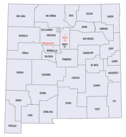
Most recently on March 6, 2020, the Office of Management and Budget defined 1114 statistical areas for the United States,[4] including 3 combined statistical areas, 4 metropolitan statistical areas, and 16 micropolitan statistical areas in the State of New Mexico. The table below shows the recent population of these statistical areas and the 33 counties of New Mexico.
Table
The table below describes the 23 United States statistical areas and 33 counties of the State of New Mexico with the following information:
- The combined statistical area (CSA) as designated by the OMB.[4]
- The CSA population according to 2019 US Census Bureau population estimates.[5]
- The core based statistical area (CBSA)[6] as designated by the OMB.[4]
- The CBSA population according to 2019 US Census Bureau population estimates [5]
- The county name
- The county population according to 2019 US Census Bureau population estimates [5]
| Combined Statistical Area | 2019 Population | Core Based Statistical Area | 2019 Population | County | 2019 Population |
|---|---|---|---|---|---|
| Albuquerque-Santa Fe-Las Vegas, NM CSA | 1,158,464 | Albuquerque, NM MSA | 918,018 | Bernalillo County, New Mexico | 679,121 |
| Sandoval County, New Mexico | 146,748 | ||||
| Valencia County, New Mexico | 76,688 | ||||
| Torrance County, New Mexico | 15,461 | ||||
| Santa Fe, NM MSA | 150,358 | Santa Fe County, New Mexico | 150,358 | ||
| Española, NM μSA | 38,921 | Rio Arriba County, New Mexico | 38,921 | ||
| Las Vegas, NM μSA | 31,798 | San Miguel County, New Mexico | 27,277 | ||
| Mora County, New Mexico | 4,521 | ||||
| Los Alamos, NM μSA | 19,369 | Los Alamos County, New Mexico | 19,369 | ||
| El Paso-Las Cruces, TX-NM CSA | 1,062,319 218,195 |
El Paso, TX CSA | 844,124 | El Paso County, Texas | 839,238 |
| Hudspeth County, Texas | 4,886 | ||||
| Las Cruces, NM MSA | 218,195 | Doña Ana County, New Mexico | 218,195 | ||
| none | Farmington, NM MSA | 123,958 | San Juan County, New Mexico | 123,958 | |
| Gallup, NM μSA | 71,367 | McKinley County, New Mexico | 71,367 | ||
| Hobbs, NM μSA | 71,070 | Lea County, New Mexico | 71,070 | ||
| Clovis-Portales, NM CSA | 67,454 | Clovis, NM μSA | 48,954 | Curry County, New Mexico | 48,954 |
| Portales, NM μSA | 18,500 | Roosevelt County, New Mexico | 18,500 | ||
| none | Alamogordo, NM μSA | 67,490 | Otero County, New Mexico | 67,490 | |
| Roswell, NM μSA | 64,615 | Chaves County, New Mexico | 64,615 | ||
| Carlsbad-Artesia, NM μSA | 58,490 | Eddy County, New Mexico | 58,490 | ||
| Taos, NM μSA | 32,723 | Taos County, New Mexico | 32,723 | ||
| Silver City, NM μSA | 26,998 | Grant County, New Mexico | 26,998 | ||
| Grants, NM μSA | 26,675 | Cibola County, New Mexico | 26,675 | ||
| Deming, NM μSA | 23,709 | Luna County, New Mexico | 23,709 | ||
| Ruidoso, NM μSA | 19,572 | Lincoln County, New Mexico | 19,572 | ||
| none | Socorro County, New Mexico | 16,637 | |||
| Colfax County, New Mexico | 11,941 | ||||
| Sierra County, New Mexico | 10,791 | ||||
| Quay County, New Mexico | 8,253 | ||||
| Guadalupe County, New Mexico | 4,300 | ||||
| Hidalgo County, New Mexico | 4,198 | ||||
| Union County, New Mexico | 4,059 | ||||
| Catron County, New Mexico | 3,527 | ||||
| De Baca County, New Mexico | 1,748 | ||||
| Harding County, New Mexico | 625 | ||||
| State of New Mexico | 2,096,859 | ||||
See also
- State of New Mexico
- Outline of New Mexico
- Index of New Mexico-related articles
- Geography of New Mexico
- Demographics of New Mexico
- New Mexico counties
- New Mexico statistical areas
- Geography of New Mexico
- Demographics of the United States
- United States Census Bureau
- List of US states and territories by population
- List of US cities by population
- Cities and metropolitan areas of the US
- United States Office of Management and Budget
- Statistical Area
- Primary Statistical Area
- List of the 725 PSAs
- Combined Statistical Area
- List of the 128 CSAs
- Core Based Statistical Area
- List of the 955 CBSAs
- Metropolitan Statistical Area
- List of the 374 MSAs
- List of US MSAs by GDP
- Micropolitan Statistical Area
- List of the 581 μSAs
- Primary Statistical Area
- Statistical Area
- United States Census Bureau
References
- The United States Office of Management and Budget (OMB) defines a metropolitan statistical area (MSA) as a core based statistical area having at least one urbanized area of 50,000 or more population, plus adjacent territory that has a high degree of social and economic integration with the core as measured by commuting ties.
- The United States Office of Management and Budget (OMB) defines a micropolitan statistical area (μSA) as a core based statistical area having at least one urban cluster of at least 10,000 but less than 50,000 population, plus adjacent territory that has a high degree of social and economic integration with the core as measured by commuting ties.
- The United States Office of Management and Budget (OMB) defines a combined statistical area (CSA) as an aggregate of adjacent core based statistical areas that are linked by commuting ties.
- OMB BULLETIN NO. 20-01: Revised Delineations of Metropolitan Statistical Areas, Micropolitan Statistical Areas, and Combined Statistical Areas, and Guidance on Uses of the Delineations of These Areas Archived 2020-04-20 at the Wayback Machine. Office of Management and Budget. March 6, 2020.
- "Annual Estimates of the Resident Population for Counties in the United States: April 1, 2010 to July 1, 2019". United States Census Bureau, Population Division. April 2020. Archived from the original on April 9, 2020. Retrieved April 9, 2020.
- The United States Office of Management and Budget (OMB) defines a core based statistical area as one or more adjacent counties or county-equivalents having at least one urban cluster of at least 10,000 population, plus adjacent territory that has a high degree of social and economic integration with the core as measured by commuting ties. The core based statistical areas comprise the metropolitan statistical areas and the micropolitan statistical areas.
External links
Santa Fe (capital) | ||
| Topics |
| |
| Society | ||
| Regions |
| |
| Cities | ||
| Counties | ||
