Tanjung Pinang
Tanjung Pinang is the capital city of the Indonesian province of the Riau Islands. It covers a land area of 144.56 km2, mainly on the southern Bintan Island, as well as other smaller islands such as Dompak Island and Penyengat Island.[3] With an estimated population of 209,280 as of 2018, it is the second largest city of the province, after Batam.[4] Tanjung Pinang is a historic city of the Malay culture, serving as the capital of Johor Sultanate and Riau-Lingga Sultanate.
Tanjung Pinang | |
|---|---|
| City of Tanjung Pinang Kota Tanjungpinang | |
| Regional transcription(s) | |
| • Jawi | تنجوڠ ڤينڠ |
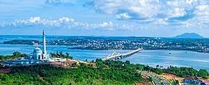 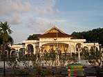    From top, left to right: City view from Dompak Island, house of governor of the Riau Islands, tombs of Riau kings, Raja Haji Fisabilillah Monument, and Sultan Sulaiman Badrul Alamsyah Museum | |
 Seal | |
| Motto(s): Jujur Bertutur Bijak Bertindak | |
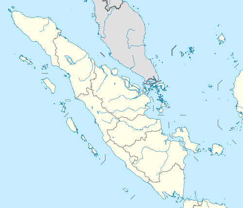
 Location within Riau Islands | |
| Coordinates: 0.918773°N 104.455415°E | |
| Country | |
| Province | |
| Founded | 6 January 1784[1] |
| Incorporated | 21 June 2001[2] |
| Government | |
| • Mayor | Rahma (acting) |
| • Vice Mayor | vacant |
| Area | |
| • Total | 812.7 km2 (313.8 sq mi) |
| • Land | 144.6 km2 (55.8 sq mi) |
| Elevation | 18 m (59 ft) |
| Population (2017) | |
| • Total | 204,735 |
| • Density | 1,416/km2 (3,670/sq mi) |
| Time zone | UTC+7 (Indonesia Western Time) |
| Area code | (+62) 771 |
| Website | tanjungpinangkota |
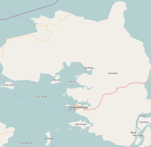

Tanjung Pinang – whose name is taken from the position of a beech tree that juts into the sea – occupies a strategic location on the south of Bintan Island, guarding the mouth of the Bintan River. Tanjung Pinang has ferry and speedboat connections to Batam, Singapore (40 km away), and Johor Bahru.
Over the centuries, Tanjung Pinang came under the control of Sumatra, Malacca, the Netherlands, Britain, and Japan. These contacts each influenced its culture, also being a centre of Malay culture and trade traffic. In the 18th century, it was a capital of the Johor–Riau–Lingga Empire.
History
The name Tanjung Pinang is taken from the position of beach nut tree that juts into the sea. Trees that are in the Cape which is a guide for voyagers who will go to Bintan River. The Tanjung Pinang River is the entrance to Bintan, where the Bentan empire was based in what is now the subdivision of Bukit Batu.
Early history
Tanjung Pinang's history can be traced to the early 3rd century, when it flourished as a trading post on the India–China trade route. Srivijaya, a Sumatra-based empire which nurtured trade with China, came to dominate much of the Malay archipelago from the 7th to 13th centuries. It declined with the rise of piracy in the region, and by the 12th century Bintan Island became known by the Chinese as "Pirate Island".
According to the Malay Annals, a Srivijaya prince named Seri Teri Buana, fleeing from the sacking of Palembang, stayed on Bintan for several years, gathering his strength before founding the Kingdom of Singapura (Singapore). A century later, it too was sacked by rival powers, and its king founded a new city at Malacca. The Malacca Sultanate (1400–1511) became one of the great empires of the region, its territories including the Riau Archipelago. Malacca was captured by the Portuguese in 1511, and the exiled Sultan Mahmud Shah established his capital at Bintan, from which he organized attacks and blockades against the Portuguese. In 1526, after a number of attempts to suppress the Malay forces, the Portuguese razed Bintan to the ground.
Johor Sultanate
Alauddin Riayat Shah II, a son of Mahmud Shah, established the Johor Sultanate in 1528. Former-Malaccan territories were quickly brought under Johor's influence, including Bintan, where an important trading port called Bandar Riau was opened. As it prospered and a war with Jambi threatened Johor in 1722, the capital was moved to Riau (now Tanjung Pinang) which became a centre of trade and Islamic studies much as Malacca had been.
A conflict with the Dutch, who had taken Malacca from the Portuguese, culminated with a Dutch fleet of 13 vessels besieging and attacking Riau. On 6 January 1784, they were met in battle by Malay and Bugis forces, and repelled with the destruction of the Dutch command ship Malaka's Wal Faren. Malay forces continued to harass the Dutch, and blockaded Malacca, but a defeat and succession crisis shifted power against them. The capital was moved from Riau to Lingga in 1788. The change of capitals has led to the Johor Sultanate sometimes being called the Johor–Riau–Lingga Empire.
The British gained control of Malacca from the Dutch in 1795. Attempting to increase their influence over the Straight of Malacca, the two powers each crowned a different candidate as Sultan of Johor–Riau during a succession crisis (1812–1818). This led to the partition of Johor–Riau under the Anglo-Dutch Treaty of 1824, which placed the territory south of the straight under Dutch control as the Riau–Lingga Sultanate.
Dutch colony and independence
The Malay were not consulted in these agreements, and relations worsened. On 11 February 1911, the Dutch deposed the sultan for defying the colonial masters, and officially annexed the sultanate which was then administered from Tanjung Pinang as the Riau Residency of the Dutch East Indies. A military base was also constructed at Tanjung Pinang.
During World War II, the Japanese occupiers made Tanjung Pinang the government centre for the Riau Islands. Control returned to the Dutch following the Japanese surrender, and the Dutch officially withdrew in 1950. Riau became one of the last territories merged into Indonesia, known as the daerah-daerah pulihan (recovered regions). Tanjung Pinang briefly became the capital of Riau Province, until the capital was moved to Pekanbaru in 1960. A law passed in 2001 defined Tanjung Pinang as an autonomous city, and it became the capital of Riau Islands Province.
Administration
The city (which is administratively separate from Bintan Regency) is divided into four districts (kecamatan), tabulated below with their areas and 2010 Census population:[5]
| Name | Area in km2 | Population Census 2010 | No. of Villages | Post Code |
|---|---|---|---|---|
| Bukit Bestari | 41.6 | 54,157 | 5 | 29122-124 |
| Tanjungpinang Timur (East Tanjung Pinang) | 61.5 | 70,867 | 5 | 29122-125 |
| Tanjungpinang Kota (Downtown Tanjung Pinang) | 41.2 | 17,026 | 4 | 29111-115 |
| Tanjungpinang Barat (West Tanjung Pinang) | 4.6 | 45,309 | 4 | 29111-113 |
Climate
Tanjung Pinang has a tropical rainforest climate (Af) with heavy rainfall year-round.
| Climate data for Tanjung Pinang | |||||||||||||
|---|---|---|---|---|---|---|---|---|---|---|---|---|---|
| Month | Jan | Feb | Mar | Apr | May | Jun | Jul | Aug | Sep | Oct | Nov | Dec | Year |
| Average high °C (°F) | 30.0 (86.0) |
30.5 (86.9) |
30.9 (87.6) |
31.2 (88.2) |
31.3 (88.3) |
31.2 (88.2) |
30.7 (87.3) |
30.9 (87.6) |
30.8 (87.4) |
30.9 (87.6) |
30.5 (86.9) |
30.2 (86.4) |
30.8 (87.4) |
| Daily mean °C (°F) | 25.8 (78.4) |
26.1 (79.0) |
26.4 (79.5) |
26.7 (80.1) |
26.9 (80.4) |
26.8 (80.2) |
26.4 (79.5) |
26.5 (79.7) |
26.6 (79.9) |
26.6 (79.9) |
26.3 (79.3) |
26.2 (79.2) |
26.4 (79.6) |
| Average low °C (°F) | 21.7 (71.1) |
21.8 (71.2) |
21.9 (71.4) |
22.2 (72.0) |
22.6 (72.7) |
22.5 (72.5) |
22.2 (72.0) |
22.1 (71.8) |
22.4 (72.3) |
22.3 (72.1) |
22.2 (72.0) |
22.2 (72.0) |
22.2 (71.9) |
| Average precipitation mm (inches) | 295 (11.6) |
177 (7.0) |
213 (8.4) |
271 (10.7) |
244 (9.6) |
215 (8.5) |
213 (8.4) |
195 (7.7) |
227 (8.9) |
253 (10.0) |
305 (12.0) |
347 (13.7) |
2,955 (116.5) |
| Source: [6] | |||||||||||||
Demographics
Religion
Islam is the dominant religion in the city, with 78.57% of the total population identify themselves as Muslim. Other religions are Buddhism, which forms 13.58% of the total population, Christianity, which forms 7.56% of the total population, Hinduism, which forms 0.02% of the total population and Confucianism, which forms 0.27% of the total population.
Landmarks
The cultural center for stage performances of Malay music and dances is located in Tanjung Pinang. The centre regularly organises festivals and other performances, such as music and dance. Renowned Buddhist temples are located outside central Tanjung Pinang in a small town named Senggarang.
Penyengat Island

The old ruler's palace and royal tombs, including the grave of Raja Ali Haji (who was the creator and author of the first Malay grammar book), are one of the many legacies left by the Riau–Lingga Sultanate. The old vice-royal mosque, the Masjid Raya, is still in use.
Notes
- Sani, Muhammad (8 February 2013). Untung Sabut Muhammad Sani (in Indonesian). Gramedia Pustaka Utama. ISBN 978-602-03-5358-6.
- RI, Setjen DPR. "J.D.I.H. - Dewan Perwakilan Rakyat". www.dpr.go.id (in Indonesian). Retrieved 3 June 2020.
- "Kabupaten - Kementerian Dalam Negeri - Republik Indonesia". web.archive.org. 31 October 2013. Retrieved 3 June 2020.
- "Badan Pusat Statistik Provinsi Kepulauan Riau". kepri.bps.go.id. Retrieved 3 June 2020.
- Biro Pusat Statistik, Jakarta, 2011.
- "Tanjung Pinang climate: Average Temperature, weather by month, Tanjung Pinang water temperature - Climate-Data.org". en.climate-data.org. Retrieved 3 June 2020.
- "Riau Islands Province in Figures 2017". BPS Kepulauan Riau. Retrieved 22 July 2018.
External links

- Official website
Regencies and cities of Riau Islands | ||
|---|---|---|
Capital: Tanjung Pinang | ||
| Regencies | ||
| Cities | ||
| Authority control |
|
|---|