Lobitos, California
Lobitos, California is a populated place in San Mateo County, just east of State Route 1 and south of Half Moon Bay and the ghost town of Purissima. It is 165 feet (50.3 m) above sea level.[1]
Lobitos, California | |
|---|---|
Populated place | |
 Lobitos, California Location within the state of California | |
| Coordinates: 37°22′59″N 122°23′57″W | |
| Country | United States |
| State | California |
| County | San Mateo |
| Elevation | 165 ft (50 m) |
| Time zone | UTC-8 (Pacific (PST)) |
| • Summer (DST) | UTC-7 (PDT) |
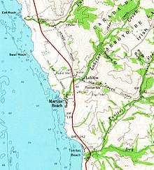
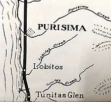
The Ocean Shore Railroad, which operated between San Francisco and Tunitas Creek from 1907 to 1920, passed near the village. There was apparently no station in Lobitos.[2] Highway 1 originally passed through Lobitos; it was later rerouted to the west of the village, closely following the old railroad route. Today, the portion of the former state highway through Lobitos has become Verde Road. The Lobitos Creek Cut-Off connects the village with Tunitas Creek Road, which runs between Highway 1 and State Route 35 (Skyline Boulevard).
Lobitos, which means 'otters' in Spanish, was originally named "Tunitas".[3]
References
- Lobitos, California: Lobitos, California Latitude and Longitude
- "Archived copy". Archived from the original on 2008-05-28. Retrieved 2008-04-14.CS1 maint: archived copy as title (link)
- http://bard.wr.usgs.gov/historical/jpg/halfmoonbay1940a.jpg; http://bard.wr.usgs.gov/historical/jpg/halfmoonbay1961a.jpg
Municipalities and communities of San Mateo County, California, United States | ||
|---|---|---|
| Cities and towns | 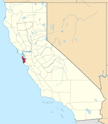 San Mateo County map | |
| CDPs | ||
| Unincorporated communities | ||
| Ghost towns | ||
| Bodies of water |
|  |
|---|---|---|
| Counties | ||
| Major cities | ||
| Cities and towns 100k–250k | ||
| Cities and towns 50k–99k | ||
| Cities and towns 25k–50k | ||
| Cities and towns 10k–25k |
| |
| Sub-regions | ||