Gudalur, Nilgiris
Gudalur is a municipality and taluk in Nilgiris district in the Indian state of Tamil Nadu. Gudalur is one of the major towns in West Tamil Nadu and is located at 52 km from Ooty in the hilly terrain of The Nilgiris district. It is situated at the junction of Tamil Nadu, Kerala and Karnataka. Gudalur is derived from Moundadan Chetty words "Gudal" (get together) and "ooru" (village). Tea plantations dot the whole region, and the regional economy is heavily dependent on the tea industry.This land was an offspring to the exploration done by the British during the pre-independence period to cultivate tea plantation. Being a satellite town between Ooty and Mysore, both tourist spots, Gudalur has the prospect of developing into another tourist destination. Gudalur is a place where one can see people from the three states of Tamil Nadu, Kerala, and Karnataka live together cordially. According to Wikipedia, Gudalur Municipality is 1st largest of Gudalur Taluk and Division, 2nd largest of Nilagiri District and 17th largest of Kongu Nadu region and 117th Largest Municipal Town of Tamil Nadu.
Gudalur | |
|---|---|
Municipality | |
 Upper Gudalur | |
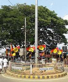
 Gudalur Location in Tamil Nadu, India | |
| Coordinates: 11.50°N 76.50°E | |
| Country | |
| State | Tamil Nadu |
| Region | Kongu Nadu |
| District | Nilgiris |
| Government | |
| • Type | Second Grade Municipality |
| • Body | Gudalur Municipality |
| • Chairperson | Rama Mani[1] |
| Elevation | 1,072 m (3,517 ft) |
| Population (2011) | |
| • Total | 49,535 |
| • Density | 200/km2 (500/sq mi) |
| Languages | |
| • Official | Tamil |
| Time zone | UTC+5:30 (IST) |
| PIN | 643212 |
| Telephone code | 04262 |
| Vehicle registration | TN 43 Z, TN 43 Y, TN 43 X |
| Sex ratio | 900/1000 ♂/♀ |
Demographics
According to 2011 census, Gudalur had a population of 49,535 with a sex-ratio of 1,032 females for every 1,000 males, much above the national average of 929.[2] A total of 5,359 were under the age of six, constituting 2,719 males and 2,640 females. Scheduled Castes and Scheduled Tribes accounted for 27.66% and 3.65% of the population respectively. The literacy rate of the town was 79.48%, compared to the national average of 72.99%.[2] The town had a total of 12101 households. There were a total of 18,807 workers, comprising 551 cultivators, 1,759 main agricultural labourers, 206 household industries, 14,488 other workers, 1,803 marginal workers, 90 marginal cultivators, 278 marginal agricultural labourers, 119 marginal workers in household industries and 1,316 other marginal workers.[3] As per the religious census of 2011, Gudalur had 59.83% Hindus, 26.01% Muslims, 14.1% Christians, 0.01% Sikhs, 0.05% following other religions and 0.01% following no religion or did not indicate any religious preference.[4]
Climate
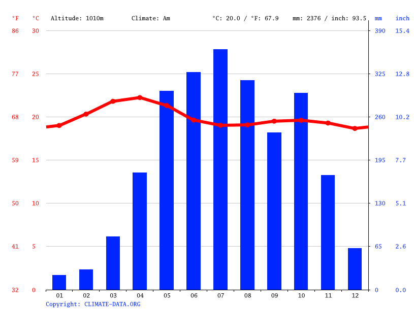
Gudalur is situated at a height of approximately 3,500 feet (1,100 m) above sea level.[5] The normal rainfall is 3000 mm per annum. While 75% of the rain is received during the southwest monsoon, (June to August) and northeast monsoon (October to November) contribution of northeast monsoon is only 15% to the total of rainfall and 8% of the rains are received during the hot weather and 2% during the winter. The weather is mainly dry during January–March and the moisture content gradually increases thereon under the influence of southwest monsoon. The wind direction is mainly west and southwest. The town of Devala in Gudalur taluk is known as Cherrapunji of the south, because of the amount of rainfall it receives annually.
Transport
Gudalur, formerly Gudalore, is linked by road to Ooty by NH 181 and this is one of the Nilgiri Ghat Roads. In the other direction, the same road continues on towards Gundlupet (and on to Mysore) in Karnataka State. Another road links it to Malappuram and Sulthan Bathery in Kerala State. Gudalur is therefore on the access route to other towns in the district for goods and passengers from the state of Karnataka and some from the state of Kerala. The Tamil Nadu State Transport Corporation provides around 70–80% of transport facilities to and within this town. This Town Has Regular bus services To Major Cities Like Ooty, Coimbatore, Bangalore, Mysore, Salem, Erode, Tiruppur, Malappuram, Calicut, etc. SETC Bus services are available to Chennai, Kanyakumari, and Pudukottai (occasionally)
Politics
M. Thiravidamani is the member of legislative assembly from Gudalur constituency
Gudalur assembly constituency is one of the three constituencies in the Nilgiris district and The Gudalur assembly constituency is part of Nilgiris (Lok Sabha constituency).[6]
History
The total area of Gudalur and the neighboring town of Pandalur is approximately 124,800 acres. In medieval times, before the arrival of the British, the area was divided between three rulers: Vallavanoor, the leader of the Panniyas, Nelliarasi, another adivasi ruler, and the Nilambur Kovilagam, a kingdom based in present-day Kerala. Subsequently, the Kovilagam decided to expand its borders by conquering the other two areas. Vallavanoor was killed and Nelliarasi kidnapped and forced to hand over her lands. Despite some resistance from Vallavanoor's community, the Kovilagam succeeded in subjugating the area and taking approximately 100,000 acres under its control.In modern times, the recognized extent of the Kovilagam's holdings was 80,087 acres under the Malabar Tenancy Act, until 1969. This area is known as 'janmom' land. Kovilagam constructed a temple named Nambalakottai and handed over to Moundadan Chetty community. Chetty community is one of the oldest community in Gudalur where most of their community still have 'Rani Patta' as a proof of oldest community. They have their own tradition and languages.
Places of interest
Places of interest include Needle Rock View Point, Frog Hill View Point, Mudumalai Wildlife Sanctuary, Mango Orange, Devala Landscapes, Nelliyalam, Moyar, Cherambady mines, Nellakotta fort, Hanging bridges (Thorapally), Genepool Garden, Devala mines, Cherangode Swami Malai, Kusumagiri Murugan Temple, Sandanamalai Temple, Masinagudi and Mudumalai wild life sanctuary
The Tropical Gene Pool at Nadugani junction has 2424 acres area. 47,000 plants. second best of its kind in the world. Museum of butterflies. Accommodation, food and trekking facility.
How To Reach
- Gudalur is located 50 km from Ooty, the headquarters of the Nilgiris district.
- Nearest Railway Station is in Ooty and Nilambur Road Railway station in Nilambur, Kerala
- Nearest Airport is Karipur International Airport which is located in Kerala and is 95 km from Gudalur. The nearest airport in the state is Coimbatore International Airport and is 135 km from Gudalur. Mysore Airport ( MYQ ) is a domestic airport in Mysore, Karnataka. It is located about 100 km from Gudalur.
- Gudalur also can be reached by bus from the neighboring states of Kerala and Karnataka.
- Bus seriveces are available to various parts of South India. Bus service to Chennai is available on everyday on 1.30 pm. Gudalur to Kanyakumari bus service is on 1.00 pm everyday via Coimbatore- Tirunelveli. Some of the Thrissur to Mysore Buses pass through Gudalur. Ooty to Bengaluru (via Mysuru) Buses passes through Gudalur.
- Proposal for a new route to join Gudalur with Sathyamangalam is in consideration. This route helps Gudalurites to reach plains like Erode and Coimbatore without travelling in mountainous roads and quicker than the usual route Gudalur - Ooty- Coonoor - Mettupalayam. This new route is an undeveloped path which connects Gudalur -Theppakkad - Siriyur- Thengumarahada-Bhavanisagar - Sathyamangalam on the banks of river Moyar. This route lies in the middle of Mudumalai - Sathyamangalam Forest. Forest department of Tamil Nadu government concerns about wildlife and bio-reserve of this region does not allow any deforestation activities like cutting of trees to lay new roads.
- Proposal for construction of railway which connects Nanjangudu (Karnataka) with Nilambur (Kerala) Via Gudalur (Tamil Nadu) Nilambur-Nanjangud line is also in consideration. This new train route would shorten around 450 km in travelling distance to reach Kanyakumari from Bangalore (Bengaluru - Mysuru - Nanjangudu - Gudalur - Nilambur - Shoranur - Trivandrum - Kanyakumari). But The route is now disjoint at two railway stations at Nanjangudu and Nilambur. Again the concern of forest department restrict the idea of construction of railway road in the mid forest of Nilgiris (Mudumalai-Muthanga-Bandipur).
References
- "Gudalur Municipality". Retrieved 6 May 2016.
- "Census Info 2011 Final population totals". Office of The Registrar General and Census Commissioner, Ministry of Home Affairs, Government of India. 2013. Retrieved 26 January 2014.
- "Census Info 2011 Final population totals - Gudalur". Office of The Registrar General and Census Commissioner, Ministry of Home Affairs, Government of India. 2013. Retrieved 26 January 2014.
- "Population By Religious Community - Tamil Nadu" (XLS). Office of The Registrar General and Census Commissioner, Ministry of Home Affairs, Government of India. 2011. Retrieved 13 September 2015.
- "Climate Graph".
- "List of Parliamentary and Assembly Constituencies" (PDF). Tamil Nadu. Election Commission of India. Archived from the original (PDF) on 31 October 2008. Retrieved 10 October 2008.
External links
| Wikimedia Commons has media related to Gudalur, Nilgiris. |
| State symbols |
| |
|---|---|---|
| Governance |
| |
| Topics | ||
| Major cities | ||
| Districts |
| |
| Lists | ||