Tiruvallur district
Tiruvallur district, also known as Thiruvallur District, is an administrative district in the Indian state of Tamil Nadu. The fast developing city of Tiruvallur is the district headquarters. The district has a mixture of urban and rural characteristics. The Eastern part of Tiruvallur district is dominated by urban characteristics while the Northern part of the district has influence of Andhra culture due to its position. As of 2011, the district had a population of 3,728,104 with a sex-ratio of 987 females for every 1,000 males
Tiruvallur district Thiruvallur district | |
|---|---|
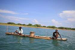 Fishermen on a catamaran on Pulicat lake | |
 Location in Tiruvallur district in Tamil Nadu | |
| Coordinates: 13°8′26.16″N 79°54′21.6″E | |
| Country | |
| State | |
| Region | Pallava Nadu, Tondai Nadu |
| Headquarters | Tiruvallur |
| Talukas | Avadi RK Pet Ponneri Gummidipoondi Uthukottai Tiruvallur Poonamallee Tiruttani Pallipattu |
| Government | |
| • District Collector | Tmt. Mageswari Ravikumar, IAS |
| • Superintendent of Police | P Aravindhan, IPS |
| • Member of Parliament | Dr K Jayakumar (Congress, DMK Alliance) |
| Area | |
| • Total | 3,423 km2 (1,322 sq mi) |
| Population (2011) | |
| • Total | 3,728,104 |
| • Rank | 4 |
| • Density | 1,100/km2 (2,800/sq mi) |
| Languages | |
| • Official | Tamil |
| Time zone | UTC+5:30 (IST) |
| PIN | 602001.600XXX,601XXX,631XXX[1] |
| Telephone code | 044 |
| Vehicle registration | TN-18, 05, 04, 12, 13, 20, 02 |
| Largest metro | Avadi (Chennai) |
| Sex ratio | 983 ♂/♀ |
| Literacy | 83.33% |
| Central location: | 13°8′N 79°54′E |
| Avg. summer temperature | 37.9 °C (100.2 °F) |
| Avg. winter temperature | 18.5 °C (65.3 °F) |
| Website | www |
The district has been divided into three revenue divisions viz, Tiruvallur, Tiruttani and Ponneri. There are four taluks under Tiruvallur division, two taluks under Tiruttani divisions and two taluks under Ponneri division. There are 46 firkas and 820 revenue villages. Likewise there are 12 blocks, 5 Municipalities and 10 town panchayats which implement rural development activities.
People of northern and eastern Tiruvallur district demanding for a new district headquartered in Red Hills by bifurcating the large Tiruvallur district.
Etymology
The word "Tiruvallur" is supposedly derived from the Tamil sentence "tiru evvull?" meaning, "Tiru" - Highness (a common prefix in South India for temple towns or cities), "evvull" - where do I sleep. So, Tiruvallur means, a place/town where, the god, Veera Raghavar asked a saint for a place to sleep for a night.[2]
Tiruvallur Don Area was originally known as Tiru-evallur which specifies the sleeping position of the holy lord "Perumal", in the Veeraragava temple of Tiruvallur. Later people began to refer it by names such as Trivellore and Tiruvallur. Today Tiruvallur is well known, one of the reason being the Veeraragava Temple, where Amavasya (the commencement of dark moon prior to the new moon) is considered an auspicious day for the lord and so for the people of the town.[3]
The district of Tiruvallur has been carved out by bifurcating erstwhile Chengalpattu district (which was renamed as Chengalpattu-MGR/Kancheepuram at the time of 1991 Census). According to the said bifurcation Tiruvallur revenue division which included Tiruvallur, Tiruttani taluks and Uthukkottai and Pallipattu sub-taluks separated from Chengalpattu district along with Ponneri and Gummindipoondi taluks of Saidapet revenue division and formed this new district. At present this district comprises 9 taluks, namely Avadi, RK Pet, Ponneri, Gummidipoondi, Uthukottai, Tiruvallur, Poonamallee, Tiruttani, and Pallipattu.
In the far past, this region was under a chain of regimes commencing from the Pallavas during the 7th century ending with the Nawab of Arcot during the early part of 19th century when it came under the British rule. In 1687, the Golkonda rulers were defeated and the region came under the Moghul emperors of Delhi. The towns and villages of this region were the scene of Carnatic wars. Battles are said to have been fought in this region during the struggle for supremacy between the English and French. The town of Pulicat was the earliest Dutch possession in India founded in 1609 which was ceded to the British in 1825. With this, the region came under the British rule which ended on 15 August 1947 with India becoming independent.[2]
Geography
It is bounded on the north by Nellore and Chittoor districts of Andhra Pradesh state, on the east by the Bay of Bengal, on the southeast by Chennai district, on the south by Kanchipuram and Chengalpattu districts, on the northwest by Vellore and on the west by Ranipet district.The coastal region of the district is mostly flat and dreary; but in the other parts it is undulating and even hilly in some places.
The northern taluks of the district like Ponneri, Uttukkottai, Gummidipundi etc. do not have much to offer from the scenic point of view. In the Tiruttani taluk, a number of hillocks are found scattered. The soil of the district is mostly sandy, mixed with soda or other alkali or stony. Rocks found in and near the surface are in detached masses. Hence, the soil can't be termed as very fertile. The soil found nearer the sea coast is of the inferior erinaceous type which is most suited for raising casuarinas plants. No mineral of any importance is available in the district. There are not many hills of any considerable height in this district. A few conical hills or ridges of small elevation exist like the St. Thomas Mount. Certain hillocks are found in Tiruttani. Most of the hills and hillocks are rocky and no verdant vegetation is seen in the slopes of these hills. The area under forests in this district is quite meager.
The average normal rainfall of the District is 1104 mm. Out of which 52% has been received during North East Monsoon period and 41% has been received during South West Monsoon period.
Demographics
| Historical population | ||
|---|---|---|
| Year | Pop. | ±% p.a. |
| 1901 | 611,211 | — |
| 1911 | 655,199 | +0.70% |
| 1921 | 688,499 | +0.50% |
| 1931 | 751,567 | +0.88% |
| 1941 | 825,255 | +0.94% |
| 1951 | 888,691 | +0.74% |
| 1961 | 981,733 | +1.00% |
| 1971 | 1,298,028 | +2.83% |
| 1981 | 1,718,487 | +2.85% |
| 1991 | 2,238,583 | +2.68% |
| 2001 | 2,754,756 | +2.10% |
| 2011 | 3,728,104 | +3.07% |
| source:[4] | ||
According to 2011 census, Thiruvallur district had a population of 3,728,104 with a sex-ratio of 987 females for every 1,000 males, much above the national average of 929.[5] A total of 405,669 were under the age of six, constituting 208,449 males and 197,220 females. Scheduled Castes and Scheduled Tribes accounted for 22.04% and 1.27% of the population respectively. The average literacy of the district was 74.88%, compared to the national average of 72.99%.[5] The district had a total of 946,949 households. There were a total of 1,538,054 workers, comprising 60,436 cultivators, 173,150 main agricultural labourers, 41,742 in house hold industries, 972,590 other workers, 290,136 marginal workers, 13,008 marginal cultivators, 97,436 marginal agricultural labourers, 16,498 marginal workers in household industries and 163,194 other marginal workers.Tamil is the official language, besides that there are some white collar English workers and north-Indian workers in the industrial corridor of gummadipoondi in the district, Telugu minority people also speak Telugu in the district, since the time of madras presidency, Telugu residents are settled in the district at 1:20 ratio of the district's population, people also speak and can understand madarasi bhashai, vada chennai bhashai at the regions of ponneri, minjur, athipattu, ennore in the district.[6]
Economy
Tiruvallur district is one of the fastest developing districts in Tamil Nadu in terms of Industrial Development. The district has many leading industries like Kamarajar Port, North Chennai Thermal Power Station, National Thermal Power Corporation, L&T Ship Build, NIOT, ITC, IOCL, HPCL, BPCL, Hindustan Motors and CPCL, Ennore (Tondiarpet). It also boasts of the Ennore Thermal Power Station and the Avadi Tank Factory.
The District has 9 Industrial Estates, all in operation: 6 developed by the Government and 3 by Private Organisation.
Government Industrial Estates
- Electrical Industrial Estate, Kakalur.
- SIDCO Industrial Estate, Kakalur
- Petrochemical Industrial Estate, Vichoor
- SIDCO Industrial Estate, R.K. Pet
- SIDCO Industrial Estate, Gummidipoondi
- SIDCO Industrial Estate, Thirumazhisai
Private Industrial Estates
- M.M.Industrial Estate, Alapakkam
- Moccaram Industries, Velappan Chavadi
- Ekambara Naicker Industrial Estate, Alapakkam
This district has 16940 Small Scale Industries, notable among them being food, wood, textile, chemical, engineering, non-metallic and leather industries.
Governance
Revenue Divisions and Taluks
Tiruvallur District consists of 3 Revenue Divisions and 9 taluks:
- Ponneri Revenue Division: Ponneri taluk, Gummidipoondi taluk
- Tiruvallur Revenue Division: Uthukkottai taluk, Tiruvallur taluk, Poonamallee taluk, Avadi taluk
- Tiruttani Revenue Division: Tiruttani taluk, Pallipattu taluk, RK Pet taluk
Below Taluks are part Of Chennai city region:
Avadi, Poonamallee, Ponneri and Tiruvallur taluks lie within the Chennai Metropolitan Area.
Revenue Blocks,Municipal Corporation and Municipalities
The following are the Revenue blocks of the district.
- Ellapuram
- Gummidipoondi
- Kadambathur
- Minjur
- Pallipattu
- Poonamallee
- Poondi
- R.K.Pet
- Sholavaram
- Tiruvallur
- Tiruttani
- Thiruvalangadu
- Andhra Pradesh, Tiruvallur District
There is 1 Municipal Corporation in Tiruvallur District.
- Avadi
- Virugambakkam
- Pattabiram
- Vepampattu
There are 4 municipalities:[7]
- Poonamallee (grade I)
- Tiruvallur (grade I)
- Thiruthani (grade II)
- Pattabiram (grade I)
New District demand
People of northern and eastern Tiruvallur district demanding for a new district headquartered in Red Hills by bifurcating the large Tiruvallur district. Those people consider Red Hills as a gateway of these regions. Where regions like Gummidipoondi, Ponneri, Pazhaverkadu depend on Red Hills rather than current district headquarters Tiruvallur. The two possibilities of creating Red Hills district by bifurcating Tiruvallur district:
- Entire region of Ponneri, Gummidipoondi, Avadi, Poonamallee taluks and parts of Uthukkottai taluk.
- Entire region of Ponneri, Gummidipoondi and Uthukkottai taluks.
People demand new district by considering the below facts:
- To facilitate smooth agricultural activities.
- To ensure balanced development of infrastructure in their region due to its proximity with Chennai city.
- To keep people closer with the government and its services.
- To help government to boost its revenue to maximum from this region.
- To attract investments on manufacturing & logistics sectors.
- To generate new employment opportunities.
- To reduce excess burden on administration of large Tiruvallur district.
- To manage administration of Chennai Metropolitan area.
- To balance the development and ecosystem of Chennai Metropolitan area.
Members of Legislative Assembly
| Constituency | Political Party |
Elected Representative |
Mobile Number | |||
|---|---|---|---|---|---|---|
| No. 001 – Gummidipoondi | AIADMK | Thiru. K.S. Vijayakumar | 9445279999 | |||
| No. 002-Ponneri (SC) | AIADMK | Thiru. P. Balaraman | 9382698074 | |||
| No. 003 – Tiruttani | AIADMK | Thiru. P.M. Narasimhan | 9443386356 | |||
| No. 004 – Tiruvallur | DMK | Thiru V.G. Raajendran | 9841037747 | |||
| No. 005 – Ponnamallee (SC) | DMK | Thiru A. Krishnaswamy | 9444932222 | |||
| No. 006 – Avadi | AIADMK | Thiru K. Pandiarajan | 9840879559 | Source: Indian Elections / Election Commission of India.[8][9] | ||
Tiruvallur assembly constituency is part of Tiruvallur (Lok Sabha constituency).[10]
Members of Parliament - Thiru. Dr. K. Jayakumar of Indian National Congress
https://tiruvallur.nic.in/mp/
https://tiruvallur.nic.in/departments/election/
https://tiruvallur.nic.in/departments/adi-dravidar-and-tribal-welfare/
https://tiruvallur.nic.in/departments/ddawo/
Updated As Per 2019 Election By Charles shyam Sundar G, Perambakkam
Economy

In retail spending, the Thiruvallur district emerges third in India, only after Noida and SW Delhi surpassing Bangalore and Mumbai by a clear margin.[11]
References
- "Tamilnadu Postal Circle - Pincode". www.tamilnadupost.nic.in. Retrieved 21 March 2018.
- tiruvallur official website
- "Sri Vaidya Veeraraghava Swami temple - Events". www.svdtiruvallur.com.
- Decadal Variation In Population Since 1901
- "Census Info 2011 Final population totals". Office of The Registrar General and Census Commissioner, Ministry of Home Affairs, Government of India. 2013. Retrieved 26 January 2014.
- "Census Info 2011 Final population totals - Thiruvallur district". Office of The Registrar General and Census Commissioner, Ministry of Home Affairs, Government of the India. 2013. Retrieved 26 January 2014.
- "List of Municipalities in Tamil Nadu Gradewise". Commissionerate of Municipal Administration, Govt. of Tamil Nadu. Archived from the original on 28 September 2012. Retrieved 13 November 2011.
- "Election results". Indian Elections. Archived from the original on 8 December 2012.
- "Parties Statistics". Election Commission of India. Archived from the original on 18 December 2008.
- "List of Parliamentary and Assembly Constituencies" (PDF). Tamil Nadu. Election Commission of India. Archived from the original (PDF) on 4 May 2006. Retrieved 8 October 2008.
- "Noida is highest spender". epaper.timesofindia.com. Retrieved 21 March 2018.
External links
| Wikimedia Commons has media related to Tiruvallur district. |
Places adjacent to Tiruvallur district | |
|---|---|
| State symbols |
| |
|---|---|---|
| Governance |
| |
| Topics | ||
| Major cities | ||
| Districts |
| |
| Lists | ||
| District Headquarters | 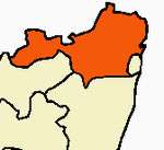 | |
|---|---|---|
| Country | ||
| State | ||
| Region |
| |
| Revenue Divisions | ||
| Taluks | ||
| Revenue blocks | ||
| Municipal Corporation |
| |
| Municipalities | ||
| Special Grade Town Panchayats | ||
| Town Panchayats | ||
| History |
| |
| Places of interest |
| |
| Universities |
| |