Kovilpatti
Kovilpatti is an industrial city and special grade municipality in Thoothukudi District in the Indian state of Tamil Nadu. It is the second largest town in the district. The town is spread around an area of 49 square kilometres (19 sq mi) and had a population of 95,097 in 2011 with the urban agglomeration having a population of around 3 lakhs. The Sithirai festival of the Shenbagavalli Poovananathar temple is celebrated annually in mid-April.
Kovilpatti | |
|---|---|
City | |
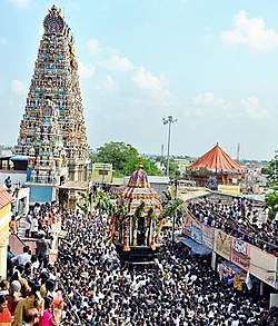 Car festival at Shenbagavalli Amman temple | |
 Kovilpatti location in Tamil Nadu, India | |
| Coordinates: 9.17°N 77.87°E | |
| Country | India |
| State | Tamil Nadu |
| District | Thoothukudi |
| Government | |
| • Type | Special grade Municipality |
| • Body | Kovilpatti Special grade Municipality |
| Area | |
| • Total | 49 km2 (19 sq mi) |
| Area rank | 23 |
| Elevation | 106 m (348 ft) |
| Population (2011) | |
| • Total | 95,097 |
| • Density | 1,900/km2 (5,000/sq mi) |
| Languages | |
| • Official | Tamil |
| Time zone | UTC+5:30 (IST) |
| Vehicle registration | TN 69, TN 96 |
| Website | municipality |
Demographics
The town already existed before 1876. Kovilpatti was a water stop for steam engines after the introduction of the Southern Railways, and the establishment of textile mills like Loyal Textiles (1891) and Lakshmi Mills Ltd (1926) fueled the economic growth of the town. The Government Revenue divisional offices were sited there in 1911. The town was constituted as a Municipal Town in 1964 composed of Kovilpatti Village and Illuppaiyurani Village. In 1961, the area of the town was 2.64 km2 with a population of 33,305; in 1971, it extended to 7.25 km2 and the population reached 48,509. In 1991, it was 12.58 km2 with a population of 78,834.
In the 2011 census, Kovilpatti had a population of 95,057. The sex-ratio of 1,065 females to 1,000 males much exceeded the national average of 929.[1] A total of 8,325 residents were under the age of six, constituting 4,158 males and 4,167 females. Scheduled Castes and Scheduled Tribes accounted for 10.32% and .84% of the population respectively. The literacy rate of the city was 81.27%, compared to the national average of 72.99%.[1] The city had a total of 25099 households in 2011. There were a total of 41,006 workers, comprising 85 cultivators, 165 main agricultural labourers, 932 in household industries, 36,989 other workers, 2,835 marginal workers, 26 marginal cultivators, 26 marginal agricultural labourers, 262 marginal workers in household industries and 2,521 other marginal workers.[2]
In the religious census of 2011, Kovilpatti was 92.29% Hindus, 2.48% Muslims, 5.12% Christians, 0.01% Sikhs, 0.01% Buddhists and 0.08% followers of other religions.[3]
Geography
Kovilpatti is located at 9.17°N 77.87°E.[4] It has an average elevation of 106 metres (347 feet). Located 100 km south of Madurai, 55 km north of Tirunelveli and 60 km north-west of Tuticorin, Kovilpatti is situated on National Highway No. 44 NH 44, which connects Srinagar in the north and Kanyakumari in the south. The town lies approximately 130 m above mean sea level. The climate of Kovilpatti town is hot and dry. Temperatures range between a maximum of 37 °C and a minimum of 22 °C. April to June are the hottest months and December and January are coldest with temperatures rising towards the end of February. Rainfall occurs mostly during the north-east monsoon in the months of October to December. However, the town receives little rainfall, averaging 840 mm compared to the district average. Annual rainfall has ranged from 964 mm to 228 mm during past decades.[5]
Politics
Kovilpatti constituency was part of Sivakasi Lok Sabha Constituency till 2008. As per order of the Delimitation Commission in respect of the delimitation of constituencies in the Tamil Nadu, the Kovilpatti constituency will be a segment of the new Thoothukkudi (Lok Sabha constituency) the member of loksabha currently is Mrs. K Kanimozhi from DMK party and the state legislative member is Mr. Kadambur Raju.[6] Delimitation was made effective for all elections in the state of Tamil Nadu that is held on or after 19 February 2008.[7] With 5 terms from 1967 to 1990, S. Alagarsamy was the longest-serving member of the Tamil Nadu Legislative Assembly representing the Kovilpatti constituency.
Education
Polytechnic
- Lakshmi Ammal polytechnic college
Engineering Colleges
- National Engineering College
- Unnamalai Institute of Technology
Arts and Science Colleges
- G. Venkataswamy Naidu College of Arts and Science
- K.R. College of Arts and Science
- S.S. Duraisamy Nadar Mariammal College
- Punitha Ohm College of Education [8]
- Govt Arts & Science College
Economy
Kovilpatti is one of the industrial cities in Tamil Nadu with almost all the Nationalized and Private banks having branches. The town started its industrial development earlier than 1891. The introduction of the Southern Railway, the establishment of Loyal Textiles (1891), Lakshmi Mills (1926), establishment of Government Revenue Divisional Offices (1911), induced the industrial growth of the town. Kovilpatti is famous for match factories, like rose matches, cycle brand, eagle box. textile mills and fireworks industry. Kovilpatti and its neighboring towns are candy paradise and most shops sell eatables like dark brown spiral candy, bright yellow wavy sev, Ellu mittai, cocoa mittai, cheeni mittai, karupatti mittai and yeni padi mittai . Kovilpatti is famous for its unique candy kadalai mittai (Ground-nut candy) and is referred as land of homemade sweets and savouries.[9]
Culture
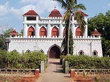
Kathiresan temple is built on a hill Kathiresan hills at west side of the city. City view from the hill is quite interesting and may enjoy fresh air.
Ettayapuram is situated about 15 km east of Kovilpatti. It is notable as a cotton growing centre. It is also famous as the birthplace of Nationalist poet and freedom fighter, Subramanya Bharathi. Points of interest are the ruins of Ettayapuram Jamin palace, the Manimandapam of Bharathiyar, the birth house of Bharathiyar, and the memorial of Sri Muthusamy Deikshidar.
Panchalankuruchi is situated 3 kilometres (1.9 mi) north of Ottapidaram, 26 km (16 mi) north-west of Thootukudi and 38 km (24 mi) south-east of Kovilpatti. The famous freedom fighter Kattabomman's fort was located here. At present only the fort remains; the rest of the settlement was destroyed by the British at the end of the war in 1799. In 1975, the government of Tamil Nadu constructed a fort in Panchalankurich in memory of the freedom fighter.
Kalugumalai is a massive dome of rock of 300 ft (91 m) height situated on the road connecting Kovilpatti and Sankarankoil, westerly. It is famous for a rock cut temple called "Vettuvankoil" and these arts also proudly called as "Southern Ellora". Another rock cut temple is dedicated to lord Subramaniya Swamy is located at the foot of the rock. The remains of "Samana Palli" or Jain school can be seen atop the hill along the Vettuvan Koil. The government of Tamil Nadu has listed this place as tourist place.
Sankarankoil is situated west of Kovilpatti. It is the site of temple of Sankara Narayanar and Gomathiamman and attracts pilgrims and devotees from the surrounding districts. The Adithapasu festival attracts large crowds every year during July or August.[10]
Transport
Kovilpatti is well connected by Road (old number NH 7 / new number NH 44) and Train. Kovilpatti Railway Station has two platforms with stoppings for Major Express and all passenger trains. St. Bobgalie's Airport a small, unused airport which is rarely used as a helipad. There is no news for AAI for any future plans for this airport. This Port might not be available after days or might be converted to an Airforce base for dump and exercises in Future. It has two bus stations, Arizhnar Anna bus stand & the new bus stand. Anna bus stand is within the town, new bus stand is in highway (old number NH 7 / new number NH 44).
Entertainment
Cinema theatre is the main form of entertainment for the people in Kovilpatti. Theatres include Sathyabama Theatre, Shanmuga Theatre, Lakshmi Theatre and AKS Theatre.
Other than theatre, there are some small parks for children, such as LPL KIDS PARK, Ram Hanuman park and Rajaji park.
Food
"Kadalai mittai" i.e. (Peanut candy/Chikki) is the signature dish of the town. It attracts people from all part of the world. Large quantities get exported to Southeast Asia, Europe and the US.It has got GI(Geographical Indication) tag from GOI in 2020
Similarly Kaaisuthu muruku, Karuppatti Mithai and Karasevu are also notable food in the Kovilpatti region.
One of the most favourite & oldest brand is MNR Hanuman Vila's MarketRoad Kovilpatti
See also
- Kovilpatti (State Assembly Constituency)
References
- "Census Info 2011 Final population totals". Office of The Registrar General and Census Commissioner, Ministry of Home Affairs, Government of India. 2013. Retrieved 26 January 2014.
- "Census Info 2011 Final population totals - Kovilpatti". Office of The Registrar General and Census Commissioner, Ministry of Home Affairs, Government of India. 2013. Retrieved 26 January 2014.
- "Population By Religious Community - Tamil Nadu" (XLS). Office of The Registrar General and Census Commissioner, Ministry of Home Affairs, Government of India. 2011. Retrieved 13 September 2015.
- Falling Rain Genomics, Inc - Kovilpatti
- "About City". Kovilpatti Municipality. 2011. Archived from the original on 17 June 2013. Retrieved 8 August 2013.
- "Press Note, Delimitation Commission" (PDF). Assembly Constituencies in Tamil Nadu. Delimitation Commission. Retrieved 12 March 2009.
- "Press Note - Schedule for General Elections, 2009" (PDF). Press Information Burueau, Government of India. Retrieved 12 March 2009.
- "Educational Institutions". Kovilpatti Municipality. 2011. Archived from the original on 4 October 2013. Retrieved 8 August 2013.
- http://www.thehindu.com/features/magazine/in-search-of-kovilpatti-kadalai-mittai/article4316161.ece
- "Places of visit". Kovilpatti Municipality. 2011. Archived from the original on 30 September 2013. Retrieved 8 August 2013.
External links
| State symbols |
| |
|---|---|---|
| Governance |
| |
| Topics | ||
| Major cities | ||
| Districts |
| |
| Lists | ||