Chennai district
Chennai district, formerly known as Madras district,[lower-alpha 1] is one of the 38 districts in the state of Tamil Nadu in India. It is the smallest and densest of all the districts in the state. Most of the Greater Chennai City comes under this district, erstwhile under Tiruvallur, Kanchipuram and Chengalpattu districts. As of 2011, the district had a population of 7,100,000 with a sex-ratio of 989 females for every 1,000 males.[3]
District of Tamil Nadu | |
 View of Marina Beach | |
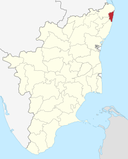 Location in Tamil Nadu, India | |
| Coordinates: | |
| Country | |
| State | |
| Region | Tondai Nadu |
| Headquarters | Chennai |
| Talukas | Alandur, Aminjikarai, Ambattur, Ayanavaram, Egmore, Guindy, Madhavaram, Maduravoyal, Mylapore, Mambalam, Purasawalkam, Perambur, Shollinganallur, Thiruvottiyur, Tondiarpet, Velachery |
| Area | |
| • Total | 426 km2 (164 sq mi) |
| Population (2011)[2] | |
| • Total | 7,100,000 |
| • Density | 17,000/km2 (43,000/sq mi) |
| Languages | |
| • Official | Tamil |
| Time zone | UTC+5:30 (IST) |
| Sex ratio | 989 female / 1000 male[3] |
| Literacy | 90.2%[3] |
| Website | https://chennai.nic.in/ |
Chennai is a megacity and local government district that contains the historic centre and the Central business district (CBD) of Chennai metropolitan area. It constituted most of Chennai from its settlement by the peoples in the 1st century CE to the Middle Ages, but the city has since grown much since then. The city forms a small part of the metropolis of Chennai, though it remains a notable part of central Chennai metropolitan area.
In 2018, the district limits were expanded, aligning with that of the newly formed Greater Chennai Corporation, which resulted in the area being increased from 178 square kilometres (69 sq mi) to 426 square kilometres (164 sq mi).[1][2] The district has three revenue divisions and ten taluks.
Etymology
The name Chennai was derived from Damarla Chennappa Nayakudu, the father of a general of the Vijayanagar Empire.[4]
Geography
Chennai district covers an area of 426 km2 located on the Eastern Coastal Plains of India. It is situated on the northeastern corner of Tamil Nadu along the Coramandel coast, a region bounded by the Bay of Bengal and is surrounded inland by the districts of Tiruvallur, Kanchipuram and Chengalpattu. It lies between 12°59' and 13°9' of the northern latitude and 80°12' and 80°19' of the eastern longitude at an average altitude of 6 metres above sea level on a 'sandy shelving breaker swept' beach. Terrain slope varies from 1:5000 to 1:10,000.[5] The terrain is very flat with contours ranging from 2 m to 10 m above mean sea level with a few isolated hillocks in the southwest beyond the district limits at St. Thomas Mount, Pallavaram and Tambaram.[6] The district runs inland in a rugged semi-circular fashion and its coastline is about 25.60 km (2.5% of the total coastline of Tamil Nadu). Because of its strategic location and economic importance, it is referred to as the "Gateway of South India." The drainage system includes two rivers, namely, Cooum (flowing in the northern part) and Adyar (flowing in the southern part), a canal (the Buckingham), and a stream (the Otteri Nullah) slicing the district into several islands.
The district falls under Seismic Zone III indicating a moderate risk of earthquake. Geologically the district is divided into three regions, namely, sandy, clayey and hard-rock regions. The soil comprises clay, shale and sandstone.[7]
Of the total land area, reserved forests cover 2.71 km2 and is concentrated in and around the Guindy National Park region, one of the few national parks in the world located within a city. The forest cover of the district is as follows:[8]
| Class | Area (Ha) | Percentage |
|---|---|---|
| Dense forest | 151.01 | 1.16 |
| Moderate dense TOF | 121.16 | 0.93 |
| Non-forest | 12,215.56 | 94.06 |
| Open forest | 114.24 | 0.88 |
| Open TOF | 153.73 | 1.18 |
| Water | 231.46 | 1.78 |
| Total | 12,987.16 | 100 |
Climate
| Climate data for Chennai, India | |||||||||||||
|---|---|---|---|---|---|---|---|---|---|---|---|---|---|
| Month | Jan | Feb | Mar | Apr | May | Jun | Jul | Aug | Sep | Oct | Nov | Dec | Year |
| Record high °C (°F) | 33 (91) |
37 (99) |
39 (102) |
43 (109) |
45 (113) |
43 (109) |
41 (106) |
40 (104) |
39 (102) |
39 (102) |
34 (93) |
33 (91) |
45 (113) |
| Average high °C (°F) | 29 (84) |
31 (88) |
33 (91) |
35 (95) |
38 (100) |
38 (100) |
36 (97) |
35 (95) |
34 (93) |
32 (90) |
29 (84) |
29 (84) |
33 (92) |
| Average low °C (°F) | 19 (66) |
20 (68) |
22 (72) |
26 (79) |
28 (82) |
27 (81) |
26 (79) |
26 (79) |
25 (77) |
24 (75) |
22 (72) |
21 (70) |
24 (75) |
| Record low °C (°F) | 14 (57) |
15 (59) |
17 (63) |
20 (68) |
21 (70) |
21 (70) |
22 (72) |
21 (70) |
21 (70) |
17 (63) |
15 (59) |
14 (57) |
14 (57) |
| Average precipitation mm (inches) | 16.2 (0.64) |
3.7 (0.15) |
3.0 (0.12) |
13.6 (0.54) |
48.9 (1.93) |
53.7 (2.11) |
97.8 (3.85) |
149.7 (5.89) |
109.1 (4.30) |
282.7 (11.13) |
350.3 (13.79) |
138.2 (5.44) |
1,266.9 (49.88) |
| Source: Indian Meteorological Department[9] | |||||||||||||
Demographics
According to 2011 census, Chennai district had a population of 7,100,000 with a sex-ratio of 989 females for every 1,000 males, much above the national average of 929. Scheduled Castes and Scheduled Tribes accounted for 16.78% and .22% of the population respectively. The average literacy of the district was 81.27%, compared to the national average of 72.99%.[3]
The district had a total of 154,982 households. There were a total of 1,817,297 workers, comprising 10,210 cultivators, 10,251 main agricultural labourers, 29,143 in house hold industries, 1,569,950 other workers, 197,743 marginal workers, 4,244 marginal cultivators, 3,423 marginal agricultural labourers, 8,202 marginal workers in household industries and 181,874 other marginal workers.[10]
Administration and politics
In 2013, five taluks on the district were split to create five new ones: Velachery, Purasawalkam, Ayanavaram, Aminjikarai and Guindy.[11]
In January 2018, the state government announced that the district will be expanded to match the boundaries of the Greater Chennai Corporation. This will integrate six additional taluks from Tiruvallur and Kanchipuram districts into the Chennai district. The new divisions and taluks of the district will be:[1][2]
The estimated population of the district is around 7.1 million.[2]
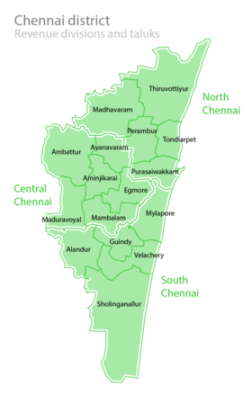
Revenue Divisions and Taluks
- North Chennai Revenue Division, headquartered at Tondiarpet, contains taluks of Tiruvottiyur, Madhavaram, Perambur, Tondiarpet, and Purasaiwalkam.
- Central Chennai Revenue Division, headquartered at Ambattur, contains the taluks of Mambalam, Egmore, Aminjikarai, Ayanavaram, Ambattur, and Maduravoyal.
- South Chennai Revenue Division, headquartered at Guindy, contains the taluks of Mylapore, Guindy, Velachery, Alandur, and Sholinganallur.
Assembly representatives
| PC No. | Constituency | Political Party |
Elected Representative |
|---|---|---|---|
| 2 | Chennai North | DMK | Dr.V. Kalanithi Veerasamy |
| 3 | Chennai South | DMK | Dr.T. Thamizhachi Thangapandiyan |
| 4 | Chennai Central | DMK | M. Dhayanithi Maaran |
| AC No. | Constituency | Political Party |
Elected Representative |
| 7 | Maduravoyal | AIADMK | Benjamin P |
| 8 | Ambattur | AIADMK | Alexander V |
| 9 | Madhavaram | DMK | Sudharsanam S |
| 10 | Tiruvottiyur | DMK | Samy.K.P.P |
| 11 | Dr. Radhakrishnan Nagar | Independent | T. T. V. Dhinakaran |
| 12 | Perambur | DMK | R.D.Sekar |
| 13 | Kolathur | DMK | M. K. Stalin |
| 14 | Villivakkam | DMK | B. Ranganathan |
| 15 | Thiru. Vi. Ka. Nagar | DMK | Thayagam kavi |
| 16 | Egmore | DMK | Ravichandiran K S |
| 17 | Royapuram | AIADMK | D. Jayakumar |
| 18 | Harbour | DMK | Sekhar babu |
| 19 | Chepauk-Thiruvallikeni | DMK | J. Anbazhagan |
| 20 | Thousand Lights | DMK | Selvan ku.ka |
| 21 | Anna Nagar | DMK | Mohan |
| 22 | Virugampakkam | AIADMK | V.N. Virugai Ravi |
| 23 | Saidapet | DMK | maa.subramanian |
| 24 | Thiyagaraya Nagar | AIADMK | D.Sathya |
| 25 | Mylapore | AIADMK | R. Nataraj |
| 26 | Velachery | DMK | Vaagai Chandrasekar |
| 27 | Sholinganallur | DMK | Aravind Ramesh S |
| 28 | Alandur | DMK | Anbarasan T M |
| Source: Office of the CEO, Tamil Nadu,[12] Indian Elections / Election Commission of India.[13][14][15] | |||
See also
- Chennai Metropolitan Area
- Districts of Tamil Nadu
Notes
- Both of these terms are also often used as metonyms for the Chennai metropolitan area's trading and financial services industries, which continue a notable history of being largely based in the City. The name Chennai is now ordinarily used for a far wider area than just the City. Chennai most often denotes the sprawling Chennai metropolis, or the 2 districts of Tamil Nadu, in addition to the City of Chennai itself. This wider usage of Chennai is documented as far back as 1639, when the madras municipal corporation was created.
References
- Dennis S. Jesudasan (5 January 2018). "Chennai district doubles in size". The Hindu. Retrieved 23 November 2019.
- Yogesh, Kabirdoss (19 January 2018). "Chennai district boundaries likely to be redrawn on April 1". The Times of India. Retrieved 23 November 2019.
- "District Census Handbook Chennai, Part XII - B" (PDF). Census of India 2011. 16 June 2014.
- "District Profile, Chennai". Government of Tamil Nadu. Archived from the original on 2012-04-15. Retrieved 27 November 2015.
- "Session-3 River and Drainage System in CMA" (PDF). CMDA. Retrieved 30 Dec 2011.
- Chapter IX Macro Drainage System in CMA
- John, Ekatha Ann (29 September 2012). "Disaster body for panel to monitor highrises in Chennai". The Times of India. Chennai. Retrieved 25 July 2015.
- "Forest at Glance". Tamil Nadu Forest Department. Archived from the original on 2011-05-20.
- "Climatological Information for Chennai". Indian Meteorological Department. Archived from the original on 2009-02-05. Retrieved 2009-01-25.
- "Census Info 2011 Final population totals – Chennai district". Office of The Registrar General and Census Commissioner, Ministry of Home Affairs, Government of India. 2013. Retrieved 26 January 2014.
- Mariappan, Julie (21 December 2013). "Chennai now has 10 taluks, as govt gets close to you". The Times of India. Retrieved 23 November 2019.
- "Chennai District MLA details" (PDF). Election Commission of India. Archived from the original (PDF) on 2013-04-02.
- "Election results". Indian Elections. Archived from the original on 2012-12-08. Retrieved 2009-12-23.
- "Parties Statistics". Election Commission of India. Archived from the original on 2008-12-18.
- "City Constituency post-delimitation details" (PDF). Election Commission of India. Archived from the original (PDF) on 2011-08-10.
External links
| Wikimedia Commons has media related to Chennai district. |
| State symbols |
| |
|---|---|---|
| Governance |
| |
| Topics | ||
| Major cities | ||
| Districts |
| |
| Lists | ||
