Dharapuram
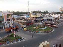
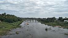
Dharapuram (officially Tharaapuram[1], தாராபுரம்) is a town in Tirupur district in the Indian state of Tamil Nadu. Dharapuram is one of the oldest towns in Tamil Nadu[2] and was the capital of Kongu Nadu under the Cheras, Western Ganga Dynasty and later Kongu Cholas, at which time it was known as Vanchipuri.[3] Amaravathi River flows through the town.[4] As of 2011, the town had a population of 67,007.Dharapuram Municipality is promoted 1st grade municipality on May 6, 1983 Dharapuram was Part of Coimbatore district in the beginning and later it moves to Erode district upto 2009. Dharapuram Town is situated along the bank of River Amaravathi, located in between 10 degree 45 minutes northern latitude and 77 degree 31 minutes eastern latitude with an extent of 7.02 km2. It is a small agricultural marketing centre for a large rural hinterland in the Tirupur District. The town is 47 km towards of the District Headquarters Tirupur, 75 km towards the Erode and 72 km towards the industrial town Coimbatore .The Nearest Airport is Coimbatore International Airport located 70km From Dharapuram.
Dharapuram (DPM) Rajarajapuram
, Vanjipuri , Viradapuram (other Names) | |
|---|---|
Historical Town(பழமையான நகரம்)
தாரை நகரம் | |
| Dharapuram | |
 Statue of Amaravathy, Dharapuram | |
| Nickname(s): Agricultural Town , Tea Town , DPM | |
 Dharapuram (DPM) Location in Tamil Nadu, India | |
| Coordinates: 10.73°N 77.52°E | |
| Country | |
| State | Tamil Nadu |
| Region | Kongu Nadu |
| District | Tiruppur district |
| Metropolitan | Coimbatore |
| Named for | Oldest Town |
| Government | |
| • Type | municipality |
| • Body | First Grade Municipality |
| Elevation | 245 m (804 ft) |
| Population (2011) | |
| • Total | 67,007 |
| Demonym(s) | Dharapuramian |
| Languages | |
| • Official | Tamil, English |
| Time zone | UTC+5:30 (IST) |
| PIN | 638656, 638657 |
| STD Code | 04258 |
| Vehicle registration | TN 78 |
| Website | municipality |
Dharapuram and Coimbatore Munipalities were established on the same day
Dharapuram Town is 55 km towards the Pollachi, 32km Towards Palani , 105 km towards Palakad (Kerala),120 km towards Madhurai, 70 km towards Dindugal ,155 km towards Ooty, 100 km Towards Kodaikanal, 156 km towards Trichy, 35 km towards Udumelpet, 120 km towards Munnar(Kerala)
Dharapuram Assembly Constitutency Was Comes Under Pollachi Lok Shaba Constituency upto 2009. Now It Comes Under Erode Lok Shaba Constituency
The town has attained the status of a Municipality in the year 1866 and functioning as the First Grade Municipality from 09.05.1983. The town developments completely depend on the agricultural activities and Commerce and Trades.
History
Dharapuram was part of the Chera kingdom until 850 A.D. From 1000 A.D. to 1275 A.D., the area was ruled by the Kongu Cholas under the name Vanchipuri. The Cholan capital was under attack by a hitherto unknown group in South India, called Kalabhars. As a result, the Kongu Cholas made Dharapuram their military and political headquarters.[5] The Later Cholas named the city as Rajarajapuram.[6] After 1276 A.D. the Pandyas took control of the region. The Sultanate, Nayaks of Madurai and Vijayanagara empire rules followed by Hyder Ali and Tippu Sultan. In 1799, when Tippu fell to the British, the East Indian Company took over administration of this region. It was also known as Virata nagaram during the time of pancha pandavas when they were in the forest incognito. The city is said to be one of the ruled areas of Panja Pandavas.
Dharapuram attained the status of a Municipality in the year 1866[7] and it was promoted to first grade municipality on May 9, 1983.[7]
Demographics
According to 2017 census, Dharapuram had a population of 1,65,007 with a sex-ratio of 1,045 females for every 1,000 males, much above the national average of 929.[8] A total of 5,048 were under the age of six, constituting 2,566 males and 2,482 females. [] The average literacy of the town was 80.4%, compared to the national average of 72.99%.[8] The town had a total of 15842 households. This area is dominated by kongu vellalar gounders, There were a total of 23,722 workers, comprising 506 cultivators, 1,227 main agricultural laborers, 652 in house hold industries, 17,553 other workers, 3,784 marginal workers, 51 marginal cultivators, 697 marginal agricultural laborers, 204 marginal workers in household industries and 2,832 other marginal workers.[9] As per the religious census of 2011, Dharapuram (M) had 77.12% Hindus, 16.76% Muslims, 5.74% Christians, and 0.37% following other religions.[10]
Geography and climate
Dharapuram is located at 10.73°N 77.52°E.[11] Dharapuram town is situated along of the bank of Amaravathi River which flows from the south to north. Uppar River and dam, Nallathankal River and dam, Palar join the river Amaravathi. It has an average elevation of 245 metres (803 feet). It is strategically located in the line of Palakkad pass which provides the wind that activates the town's numerous windmills. The area has a significant water shortage. The town has a hot semi-arid climate (Köppen climate classification;BSh).
| Climate data for Dharapuram | |||||||||||||
|---|---|---|---|---|---|---|---|---|---|---|---|---|---|
| Month | Jan | Feb | Mar | Apr | May | Jun | Jul | Aug | Sep | Oct | Nov | Dec | Year |
| Average high °C (°F) | 29.4 (84.9) |
32.9 (91.2) |
33.6 (92.5) |
35.2 (95.4) |
36.3 (97.3) |
35.1 (95.2) |
32.8 (91.0) |
32.7 (90.9) |
32.5 (90.5) |
31.1 (88.0) |
30.5 (86.9) |
29.0 (84.2) |
32.6 (90.7) |
| Average low °C (°F) | 19.6 (67.3) |
21.2 (70.2) |
22.9 (73.2) |
23.3 (73.9) |
24.7 (76.5) |
25.4 (77.7) |
24.8 (76.6) |
23.6 (74.5) |
23.5 (74.3) |
22.0 (71.6) |
21.0 (69.8) |
20.1 (68.2) |
22.7 (72.8) |
| Average precipitation mm (inches) | 14 (0.6) |
11 (0.4) |
22 (0.9) |
43 (1.7) |
65 (2.6) |
34 (1.3) |
21 (0.8) |
31 (1.2) |
50 (2.0) |
134 (5.3) |
138 (5.4) |
44 (1.7) |
607 (23.9) |
| Source: Dharapuram Municipality | |||||||||||||
Economy
Agriculture is the primary industry in Dharapuram,Coconut Cultivation is the major part of Agriculture. There are textile mills, rice mills, oil processing plants. Out of total population, 23,722 were engaged in work or business activity. Of this 16,674 were males while 7,048 were females. In census survey, worker is defined as person who does business, job, service, and cultivator and labour activity. Of total 23722 working population, 84.05 % were engaged in Main Work while 15.95 % of total workers were engaged in Marginal Work.
Administration and politics
Dharapuram has been reserved constituency from 1967 to still day. The assembly constituency (SC) is part of Erode (Lok Sabha constituency).[12] V.S.Kalimuthu is a present member of the Tamil Nadu Legislative Assembly from the Dharapuram constituency.[13] Dharapuram Revenue division consists of Dharapuram taluk and Kangeyam taluk. DMK, AIADMK, INC, DMDK, PMK, ADMK are the major political parties in this area. Dharapuram Block comes under Dharapuram assembly constituency, current sitting MLA is Kalimuthu. V.S contested and won from INC party Dharapuram Block comes under Erode parliament constituency, current sitting MP is Ganesha Moorthy.A Dharapuram Block Political Map. The municipality commissioner Thiru.R.Lakshmnan B.E. Dharapuram was a part of Coimbatore district and later Erode district
Transport
The following are the major highways connecting Dharapuram:
- SH-21 : Pollachi - Dharapuram- karur
- SH-37 : Oddanchatram - Dharapuram - Tiruppur
- SH-81 : Gobichettipalayam- Dharapuram
- SH-83 : Palani - Dharapuram
- SH-83A : Erode - Kangeyam - Dharapuram
- SH-84A : Erode - vellakovil - Dharapuram
- SH-97 : Udumalpet - Dharapuram
- SH-153 : Dharapuram - Palani
- SH-174A : Coimbatore - Palladam - Dharapuram
Every 5 minutes once buses available for Coimbatore, Tirupur, Erode, Palani and Madurai , midnight time every 15 minutes once buses available.
Every 20 minutes buses Available for Karur, Pollachi (5am to 10 pm).
There Are Some Main Area Buses Available for velankanni, Nagercoil, Tirunelveli, Rameswaram, Mysore , Hosur, Sivakasi, Thoothukudi, Tiruchendur, Ooty, Chennai , Salem, Bengaluru At Perticular Period of time at Dharapuram Bus stand.
Dharapuram is connected by moffusil bus services to major towns in Tamil Nadu operated by TNSTC
The nearest railway station is Palani and udumalpet (35 km) and the nearest airport is Coimbatore International Airport (70 km). Dharapuram town is well connected with other cities & towns like Coimbatore, Erode, Karur, Dindigul, Tiruppur, Madurai, Oddanchatram, Palani, Udumalpet and Pollachi with road transport facilities. Dharapuram town is not provided with railway facilities. The nearest railway station is at palani and udumalpet located at a distance of 34 km and 35 km respectively. There are two State Highways roads one is Erode - Oddanchatram road and other one is Pollachi - Dharapuram - Karur road. Apart from these there are five Major District Roads and two other District Roads are passes through this town. Dharapuram town is well connected with the District Headquarters, Coimbatore, Erode, Karur, Dindigul and other urban centres like, Tiruppur, Palani, Oddanchatram, Udumalpet, and Pollachi with road transport facilities. The total length of roads within the corporate limit is 57.85 km which consists of 17.37 km length of cement road 38.557 km length of B.T. roads, 0.356 km length of W.B.M. road and 1.567 km length of earthen roads. The major District Road, Coimbatore Alangiyam Road and Pollachi - Dindigul - Karur road connects the Dharapuram town with the important urban centres. The street pattern in the core area of the town and the traffic is heavy due to location of educational institutions and public offices. There are too many convergencies on the main road to Coimbatore and Pollachi and consequently is the most congested of the roads. Other than Municipal roads of length 57.85 km there are six State Highways road of 9.69 km length and 7.8 km length of Major District Road and Other District Road.
The main mode of mass transportation in and out of the town is the buses operated by a number of private companies and the State Transport Corporation. There are at present 11 bus routes operator from Dharapuram Busstand. On these bus routes about 360 buses and 12 mini – buses operate making about 2187 single trips catering to 38,000 passengers per day. The trips includes to long distance towards like Coimbatore, Madurai, Trichi, Erode, etc. All parts and surrounding villages located at a distance of 30 km of the town are well connected by town buses.
Dharapuram town is not provided with railway facilities. The nearest Railway station is at Palani located at a distance of 34 km. Also Udumalaipet and Oddanchatram railway stations which are at a 35km and 40 km distance respectively. Major Junction is at Erode 80km and Coimbatore at 80 km
The nearest Airport is located in Coimbatore which is 70 km distance from the town.
Places of interest

Agastheeswarar temple, Bhagavan Koil, Angalamman temple, Kottai Mariamman temple, Rathinamoorthy temple, Thean Easwaran temple, Periya Nachiamman temple, Konguvadukanatha Swami temple, Thillapuriamman Temple, Chakrathalvar temple, Mamangam temple, Kadu Hanumantharaya Swami temple and Angitholuvu Kaliamman temple are the major places of worship.
Education
Many higher secondary schools are available:
- Government Higher Secondary School, Dharapuram (Boys), started in 1857
- St. Aloysius Hr. Sec. School for Girls Dharapuram
- N.C.P Municipal Higher Secondary School for Boys Dharapuram
- Veveaham Higher Secondary boys School Dharapuram
- Veveaham Higher Secondary girls School Dharapuram
- Centwin Matriculation Higher secondary school Dharapuram
- CSI Boys Higher Secondary School Dharapuram
- CSI Girls Higher Secondary School Dharapuram
- Govt. High School for Girls Dharapuram
- Thenmalar Higher Secondary School Dharapuram
- Sindhu matric Higher Secondary & sainik school Dharapuram
- Vishnu Lakshmi Matric Higher Secondary School Dharapuram
- Ponnu Matriculation Higher Secondary School Dharapuram
- V.M.C.D.V Higher Secondary School, (Thayampalayam) Dharapuram
- Govt. Higher Secondary School, (Kundadam) Dharapuram
- Govt. Higher Secondary School, Kolathuppalayam Dharapuram
- Manikaswamy Naidu Higher Secondary School Gvp, Dpm
- Govt. High School (Elugamvalasu) and Govt. High School (Kuppichipalayam) Dharapuram,
- Dr. Nallini High School, Dharapuram
CBSE SCHOOL
- Agaram Public School (CBSE), Karur Main Road, Dharapuram
SAINIK SCHOOL
- Sindhu matric Higher Secondary School & sainik school Dharapuram
Colleges
- Govt ITI DPM and two more private ITIs
- Bishop Thorp College Dharapuram
- Bishop Nursing College Dharapuram
- Sara Nursing College Dharapuram
- TRN Polytechnic College Dharapuram
- Maharani Arts and Science College for Women Dharapuram
- Maharani college of education Dharapuram
- Maharani teacher training institute Dharapuram
- Maharani Polytechnic College Dharapuram
- Dr. Nallini Institute of Engineering and Technology, Dharapuram
- Dr. Nallini College of Education, Dharapuram
- Dr. Nallini Institute of Teacher Training Dharapuram
- Vishnu Lakshmi B.Ed college Dharapuram
Notable people
- Nagesh, film actor
- A. Senapathi Gounder, politician
- S. K. Kharventhan, politician
- K. V. Ramalingam, politician
- A.Chella durai, politician
- Theodore Baskaran, Film Historian
- R.Sundararajan (Movie Director)
- Mylvahanan Senthilnathan (Cricketer)
- Dharapuram Sundararajan (Music Director)
- Halitha shameem , Movie Directer
- Chaplin Balu, film actor
Business
Agriculture is the primary industry in Dharapuram. There are Textile (Spinning or Cotton) Mills, Rice Mills, Oil Processing Plants, Bricks, Big Lorry Market, Famous vegetables Market, Automobiles and Finance.There are spinning mills,Ginning factory,Rice mills,Seed manufacturing companies in Dharapuram and Gokulraj Ginning factory is one of the biggest industry located here
Banks and ATM
- State Bank of India with ATM
- Canara Bank with ATM
- ICICI Bank with ATM
- Indian Overseas Bank with ATM
- Indian Bank with ATM
- Lakshmi Vilas Bank with ATM
- Axis Bank with ATM
- Karur Vysya Bank with ATM
- HDFC Bank with ATM.
- Central Bank Of India
- Punjab National Bank with ATM
- Andhra Bank with ATM
- City Union Bank with CDM and ATM
- Tamilnad Mercantile Bank
- Corporation Bank
- Dharapuram Co Op Urban Bank
- Bank of Baroda with ATM
See also
References
| Wikimedia Commons has media related to Dharapuram. |
- manimalar (2020-06-11). "TN Government Renamed English Names for Various Cities". Hindi Examsdaily. Retrieved 2020-06-11.
- "History Of Tipu Sultan By Mohibbul Hasan". Archive.org. Retrieved 2013-08-15.
- "Tiruppur which helped grow Tamil". Dinamalar. 2010-06-18. Retrieved 2013-08-15.
- "Tiruppur District - Rivers". Tiruppur.nic.in. Retrieved 2013-08-15.
- "Villages in Dharapuram Tehsil in Erode". Erode.org.in. Archived from the original on 2014-01-02. Retrieved 2013-08-15.
- ஔவை. சு. துரைசாமிப் பிள்ளை (2002). சேரமன்னர் வரலாறு. சென்னை: வள்ளுவர் பண்ணை. p. 215.
- "Welcome to Dharapuram Municipality Home Page". Municipality.tn.gov.in. 1983-05-06. Archived from the original on 2012-09-24. Retrieved 2013-08-15.
- "Census Info 2011 Final population totals". Office of The Registrar General and Census Commissioner, Ministry of Home Affairs, Government of India. 2013. Retrieved 26 January 2014.
- "Census Info 2011 Final population totals - Dharapuram". Office of The Registrar General and Census Commissioner, Ministry of Home Affairs, Government of India. 2013. Retrieved 26 January 2014.
- "Population By Religious Community - Tamil Nadu" (XLS). Office of The Registrar General and Census Commissioner, Ministry of Home Affairs, Government of India. 2011. Retrieved 13 September 2015.
- Falling Rain Genomics, Inc - Dharapuram
- "List of Parliamentary and Assembly Constituencies" (PDF). Tamil Nadu. Election Commission of India. Archived from the original (PDF) on 2009-02-06. Retrieved 2008-10-11.
- "List of MLAs from Tamil Nadu 2011" (PDF). Govt. of Tamil Nadu. Archived from the original (PDF) on 2012-03-20.