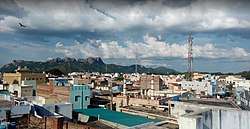
Pernambut
Pernambut is a town and village headquarters also a Municipality in Vellore district in the Indian state of Tamil Nadu. As of 2011, the town had a population of 51,271. Pernambut is the second most populated town in Vellore District after separation of Tirupattur and Ranipet Districts. The economy is dependent on leather tanning industry, earning it the nickname Leather Tanning city of Tamil Nadu.Pernambut is a municipality and headquarters of Pernambut taluk which is an administrative division comprising 52 Revenue villages in the district of Vellore.
Pernampattu[1] | |
|---|---|
Headquarters [2] | |
 Pernambut Town | |
| Nickname(s): Leather City | |
 Pernampattu[5] Location in Tamil Nadu, India | |
| Coordinates: 12.9387°N 78.7028°E | |
| Country | |
| State | Tamil Nadu |
| District | Vellore district |
| Government | |
| • Type | Municipality |
| • Body | Pernambut Municipality |
| Area | |
| • Total | 12.97 km2 (5.01 sq mi) |
| Population (2011)[6] | |
| • Total | 51,271 |
| • Density | 4,000/km2 (10,000/sq mi) |
| Languages | |
| • Official | Tamil, Urdu |
| Time zone | UTC+5:30 (IST) |
| PIN | 635810 |
| Telephone code | 04171 |
| Vehicle registration | TN-23 |
| Sex ratio | 1028 ♂/♀ |
Tourism
Pernambut[7] is multi cultured town, here you can see people of all religion, the most important religious places are Muslim Worship places in Pernambut consists: Chowk Masjid, Jamiya Masdjid,Nawab Daryakhan Masjid - Founded in 1814,Park Masjid,Road Masjid e Ahle Hadees- Founded in 1899.new Masjid e Ahle Hadees- Founded in 1935.Small Masjide Ahle Hadees- Founded in 1816.Masjid-E-Istiqamath Ahle HadeesForquan Masid Ahle Hadees,Masjid-E-Hassaniya Ahle Hadees Ahle Hadees Jamiya Masjid,Masjid-E-Shekul hadees-Ahle Hadees and many more Hindu Worship places in pernambut include koils Aanchaneyar Koil, Krishnan koil, Vinayagar Koil, Venkatesa Perumal With Sri Devi and Bodevi Koil. Christian Worship places in pernambut include St. Pauls Lutheran church - IELC, Church of God - COG
Demographics
According to 2011 census, Pernampattu had a population of 51,271 with a sex-ratio of 1,028 females for every 1,000 males, much above the national average of 929.[8] A total of 6,866 were under the age of six, constituting 3,452 males and 3,414 females. Scheduled Castes and Scheduled Tribes accounted for 23.57% and .02% of the population respectively. The average literacy of the town was 68.94%, compared to the national average of 72.99%.[8] The town had a total of 10450 households. There were a total of 16,523 workers, comprising 62 cultivators, 103 main agricultural labourers, 1,602 in house hold industries, 12,838 other workers, 1,918 marginal workers, 30 marginal cultivators, 18 marginal agricultural labourers, 158 marginal workers in household industries and 1,712 other marginal workers.[6] As per the religious Pernambut is multi cultured city, here you can see people of all religion, the most important religion are : – Islam – Hindu – Christian. Census of 2011, Pernampattu (M) had 36.44% Hindus, 61.56% Muslims, 1.72% Christians, 0.02% Sikhs, 0.0% Buddhists, 0.1% Jains, 0.15% following other religions and 0.0% following no religion or did not indicate any religious preference.[9] Note: More Christians are not changing there religion in community certificate if they changing as per government norms scholarship not given by Tamil Nadu Government, most of the people more poor in this town so that the reason they hiding the religion Christianity.
Climate
| Climate data for Pernambut (1971-2000) | |||||||||||||
|---|---|---|---|---|---|---|---|---|---|---|---|---|---|
| Month | Jan | Feb | Mar | Apr | May | Jun | Jul | Aug | Sep | Oct | Nov | Dec | Year |
| Record high °C (°F) | 29.7 (85.5) |
32.5 (90.5) |
35.7 (96.3) |
38.4 (101.1) |
39.0 (102.2) |
36.6 (97.9) |
34.9 (94.8) |
34.2 (93.6) |
34.1 (93.4) |
32.3 (90.1) |
29.9 (85.8) |
28.7 (83.7) |
33.8 (92.8) |
| Average low °C (°F) | 17.8 (64.0) |
19.3 (66.7) |
21.3 (70.3) |
24.7 (76.5) |
25.9 (78.6) |
25.6 (78.1) |
24.7 (76.5) |
24.2 (75.6) |
23.5 (74.3) |
22.3 (72.1) |
20.6 (69.1) |
18.7 (65.7) |
22.4 (72.3) |
| Average precipitation mm (inches) | 9.4 (0.37) |
4.5 (0.18) |
12.3 (0.48) |
24 (0.9) |
65.9 (2.59) |
76.8 (3.02) |
129.3 (5.09) |
144.7 (5.70) |
185 (7.3) |
146.2 (5.76) |
147.7 (5.81) |
84.5 (3.33) |
1,030.4 (40.57) |
| Average rainy days | 0.8 | 0.3 | 0.8 | 1.3 | 4.2 | 5.2 | 7.1 | 8.0 | 8.7 | 8.1 | 7.4 | 4.0 | 56 |
| Source: India Meteorological Department (record high and low up to 2010)[10][11] | |||||||||||||
Another source with different averages.
| Climate data for Pernambut | |||||||||||||
|---|---|---|---|---|---|---|---|---|---|---|---|---|---|
| Month | Jan | Feb | Mar | Apr | May | Jun | Jul | Aug | Sep | Oct | Nov | Dec | Year |
| Average high °C (°F) | 9.2 (48.6) |
11.1 (52.0) |
15.3 (59.5) |
20.2 (68.4) |
24.3 (75.7) |
25.1 (77.2) |
21.7 (71.1) |
20.8 (69.4) |
20.7 (69.3) |
18.8 (65.8) |
15.8 (60.4) |
12 (54) |
17.9 (64.3) |
| Daily mean °C (°F) | 5.6 (42.1) |
7.3 (45.1) |
11.2 (52.2) |
15.9 (60.6) |
19.8 (67.6) |
20.9 (69.6) |
18.9 (66.0) |
18.2 (64.8) |
17.5 (63.5) |
15 (59) |
11.6 (52.9) |
8.2 (46.8) |
14.2 (57.5) |
| Average low °C (°F) | 2.1 (35.8) |
3.5 (38.3) |
7.2 (45.0) |
11.6 (52.9) |
15.4 (59.7) |
16.8 (62.2) |
16.1 (61.0) |
15.7 (60.3) |
14.3 (57.7) |
11.2 (52.2) |
7.5 (45.5) |
4.5 (40.1) |
10.5 (50.9) |
| Average precipitation mm (inches) | 66 (2.6) |
63 (2.5) |
70 (2.8) |
45 (1.8) |
61 (2.4) |
163 (6.4) |
411 (16.2) |
343 (13.5) |
172 (6.8) |
44 (1.7) |
13 (0.5) |
29 (1.1) |
1,480 (58.3) |
| Source: Climate-Data.org, altitude: 2103m[12] | |||||||||||||
Economy and culture
The economy is dependent on the leather industries, glue factories as well as beedi factories where more of the locals work.[13] The town houses leather tanning and manufacturing facilities and is a leading cluster for export of finished leather and leather-related products. Pernambut is known for its Unani Medicine especially. Ramzan and Bakrid festivals are celebrated by Muslims, Diwali and Pongal by Hindus and Christians celebrate Easter and Christmas.Paddy, Banans, coconuts, groundnuts, corn, soya, vegetables are cultivated here.
Transport
The Town is having a good transport facilities for all directions and major National Highways passing through Pernambut is NH75 which connects Mangalore, Bangalore and Vellore. State Highways major district roads and village roads. These roads are having access to surrounding important towns like Ambur, Vaniyambadi, Gudiyatham, Pallikonda and Vellore. It also connects metro cities of Chennai and Bangalore. The nearest international airports are Chennai International Airport (190 km) and Bengaluru International Airport (180 km);. Pernambut is well-connected by road. National Highway 75 (NH 75) connects Pernambut to the nearest big city of Vellore. Pernambut is connected by road to all the major towns State Highways major district roads and village roads. Distance between major cities and towns from Pernambut: Distance between major towns and Pernambut:
Politics
Pernambut assembly constituency (SC) was part of Vellore (Lok Sabha constituency) now it is part of Gudiyatham Assembly Constituency
References
- new tmilnadu gazzette-new names for places
- refer vellore district portal
- new tmilnadu gazzette-new names for places
- new tmilnadu gazzette-new names for places
- new tmilnadu gazzette-new names for places
- "Census Info 2011 Final population totals - Pernampattu". Office of The Registrar General and Census Commissioner, Ministry of Home Affairs, Government of India. 2013. Retrieved 26 January 2014.
- http://pernambut.weebly.com/worship-places.html
- "Census Info 2011 Final population totals". Office of The Registrar General and Census Commissioner, Ministry of Home Affairs, Government of India. 2013. Retrieved 26 January 2014.
- "Population By Religious Community - Tamil Nadu" (XLS). Office of The Registrar General and Census Commissioner, Ministry of Home Affairs, Government of India. 2011. Retrieved 13 September 2015.
- "Pernambut Climatological Table Period: 2006-2015". India Meteorological Department. Retrieved 10 April 2015.
- "Ever recorded Maximum and minimum temperatures up to 2010" (PDF). India Meteorological Department. Archived from the original (PDF) on 21 May 2013. Retrieved 10 April 2015.
- "Climate: Pernambut – Climate graph, Temperature graph, Climate table". Climate-Data.org. Retrieved 28 August 2013.
- "Leather Factory in Pernambut". Weebly.com.
External links
| State symbols |
| |
|---|---|---|
| Governance |
| |
| Topics | ||
| Major cities | ||
| Districts |
| |
| Lists | ||