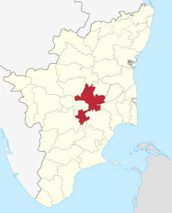
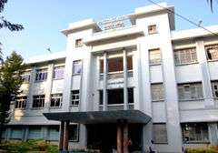
Tiruchirappalli district
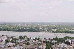
Tiruchirappalli District is located along the Kaveri River in Tamil Nadu, India. The main town in Tiruchirappalli District is the city of Tiruchirappalli, also known as Trichy. During the British Raj, Tiruchirappalli was known as Trichinopoly, and was a district of the Madras Presidency; it was renamed upon India's declaration of independence in 1947. As of 2011, the district had a population of 2,722,290 with 1,013 females for every 1,000 males.
Geography
Tiruchirappalli district lies within Tamil Nadu. The district has an area of 4,404 square kilometers. It is bounded in the north by Salem district, in the northwest by Namakkal district, in the northeast by Perambalur district and Ariyalur district, in the east by Thanjavur District, in the southeast by Pudukkottai district, in the south by Madurai district and Sivagangai district, in the southwest by Dindigul district and, in the west by Karur district. The Kaveri river flows through the length of the district and is the principal source of irrigation and drinking water.
Demographics
According to 2011 census, Tiruchirappalli district had a population of 2,722,290 with a sex-ratio of 1,013 females for every 1,000 males, much above the national average of 929.[2] A total of 272,456 were under the age of six, constituting 139,946 males and 132,510 females. Scheduled Castes and Scheduled Tribes accounted for 17.14% and 0.67% of the population respectively. The average literacy of the district was 74.9%, compared to the national average of 72.99%.[2] The district had a total of 698,404 households. There were a total of 1,213,979 workers, comprising 161,657 cultivators, 319,720 main agricultural labourers, 25,174 in house hold industries, 575,778 other workers, 131,650 marginal workers, 9,012 marginal cultivators, 59,062 marginal agricultural labourers, 5,212 marginal workers in household industries and 58,364 other marginal workers.[3]
| Historical population | ||
|---|---|---|
| Year | Pop. | ±% p.a. |
| 1901 | 807,320 | — |
| 1911 | 876,070 | +0.82% |
| 1921 | 912,177 | +0.40% |
| 1931 | 918,342 | +0.07% |
| 1941 | 1,035,927 | +1.21% |
| 1951 | 1,184,158 | +1.35% |
| 1961 | 1,304,039 | +0.97% |
| 1971 | 1,650,768 | +2.39% |
| 1981 | 1,900,566 | +1.42% |
| 1991 | 2,196,473 | +1.46% |
| 2001 | 2,418,366 | +0.97% |
| 2011 | 2,722,290 | +1.19% |
| source:[4] | ||
Taluks
.jpg)
In 2013, Tiruchirappalli district went from nine taluks to eleven taluks.[5]
Urban centres
Tiruchirappalli District consists of the following urban centres:
- Trichy City
- Manapparai town
- Thuraiyur town
- Thuvakudi town
- Lalgudi town panchayat
- Manachanallur town panchayat
- Musiri town panchayat
- Thottiyam town panchayat
- Kolli Hills (Kollimalai) tourist town
- Uppiliapuram Town panchayat
- Navalurkuttapattu panchayat
- Mettupalayam panchayat
- B.Mettur panchayat
- Balakrishnampatti panchayat
- Thataiyagarpettai panchayat
- mangalam panchayat
Major industries
- Bharat Heavy Electricals Limited (BHEL)
- Heavy Alloy Penetrator Project (HAPP)
- Golden Rock Railway Workshop
- Ordnance Factory Tiruchirappalli
- Light and heavy engineering
- Leather Tanneries
- Food Processing
- Sugar Mills
- (Traditional) Cigar Making (village) Industries
- Hosiery and garments (to a small extent)
- IT/BPO
- Manufacturing of Synthetic Stones for Jewelry
Natural resources and water bodies
The major rivers are the River Kaveri and the River Kollidam. The important rivers across city is Koraiyar, Uyyakondan and Kudamuruti rivers.
Agriculture
The district has a large cattle and poultry population with agriculture workers in the smaller villages like Kalpalayathanpatti.
The rivers Caveri and Kollidam start branching out to form the Caveri delta irrigating vast tracts of land in the district. The major crops are rice (vast tracts); sugarcane (vast tracts); banana/plantain; coconut; cotton (small tracts); betel; corn; and groundnut.
Tourism
Places to visit in Tiruchirappalli District:
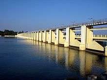
- Kallanai Dam
- Tropical butterfly conservatory, Trichy
- Manaparai madu-karungulam jalli kattu
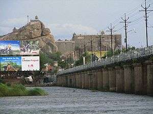
- Tiruchirappalli Fort
- Kaveri Palam
- Tiruchirappalli International Airport
- Trichy Teppakulam
- Gandhi Market
- railway Heritage Centre, Tiruchirappalli
- Government Museum, Tiruchirappalli
- Chokkanatha Nayak Palace
- Government Museum, Tiruchirappalli
- Mukkombu
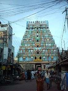
- Srirangam Ranganathaswamy Temple
- Erumbeeswarar Temple
- Ponmalai (Golden Rock)
- Bikshadaar Temple
- Thiruvanai koil Shiva temple
- Vayalur Murugan Temple
- Kulumandi Amman Temple, Puthur-Sholanganallur
- Samayapuram Mariamman Temple
- Vekkaliamman Temple, Woriyur
- Rock Fort and Uchipillaiyar Temple
- Tolgate Utthamar Koil Temple
- Tirupattur Bramha Temple
- Puliancholai falls
- Pachai malai hill station
- Kolli malai hill station
- Lalgudi sivan temple
- Saint Joseph Church
- Viralimalai murugan temple
- natharsha vali darga
- ponnaniyaru dam, vaiyampatti
- kannuththu wild life forest, elamanam, manaparai
- ponnambalapatti forest, manaparai
- Manaparai murukku
- Geelivaneswaran Temple, Thiruppainjili.
- Pundaraikatcha Perumal Temple, Thiruvellarai.
- Vallakulathu Karuppanan Temple,Valaiyur.
- Pallividai Church
- Butterfly park
- Kambaraspettai dam
- mangalam shiva temple
- musiri periyar way
- World War I Memorial (Tiruchirappalli)
References
- www.tn.gov.in
- "Census Info 2011 Final population totals". Office of The Registrar General and Census Commissioner, Ministry of Home Affairs, Government of India. 2013. Retrieved 26 January 2014.
- "Census Info 2011 Final population totals - Tiruchirappalli district". Office of The Registrar General and Census Commissioner, Ministry of Home Affairs, Government of India. 2013. Retrieved 26 January 2014.
- Decadal Variation In Population Since 1901
- "Residents question move to locate Marungapuri taluk office at Kallupatti". The Hindu. 21 June 2013.
External links
| Wikimedia Commons has media related to Tiruchirapalli district. |
Places adjacent to Tiruchirappalli district | ||||||||||
|---|---|---|---|---|---|---|---|---|---|---|
| ||||||||||
| State symbols |
| |
|---|---|---|
| Governance |
| |
| Topics | ||
| Major cities | ||
| Districts |
| |
| Lists | ||
| District headquarters | 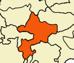 | ||||||
|---|---|---|---|---|---|---|---|
| Country | |||||||
| State | |||||||
| Region | |||||||
| Divisions | |||||||
| Taluks | |||||||
| Revenue blocks | |||||||
| Municipal corporations | |||||||
| Municipalities | |||||||
| Rivers | |||||||
| History |
| ||||||
| Places of interest |
| ||||||
| Educational institutions |
| ||||||
| |||||||