Punjai Puliampatti
Punjai Puliampatti is a Municipality is a suburb and emerging local economy in Sathyamangalam taluk, Erode District in the Indian state of Tamil Nadu.
Punjai Puliyampatti Puliampatti | |
|---|---|
 Punjai Puliyampatti Location in Tamil Nadu, India | |
| Coordinates: 11.35°N 77.168°E | |
| Country | |
| State | Tamil Nadu |
| Region | Kongu Nadu |
| District | Erode |
| Government | |
| • Type | Second Grade Municipality |
| • Body | Punjai Puliampatti Municipality
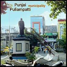 statue in Punjai puliampatti municipality office |
| Elevation | 312 m (1,024 ft) |
| Population (2019) | |
| • Total | 25,000 |
| Languages | |
| • Official | Tamil |
| Time zone | UTC+5:30 (IST) |
| PIN | 638459 |
| Vehicle registration | TN-36 |
Future of Town development
The municipality area will be expanded to cover Nallur-Nehru Nagar,Madhampalayam and Nochikuttai panchayats into punjai puliampatti municipality area as per official sources. The Town will be serviced with fire service station and new municipality building & subregister office building as per official TN government sources. The people of the town are demanding regular and uninterrupted water supply,Taluk status and other Taluk related offices as the population reaching equivalent to sub district population and as a major industrial suburb.
The National Highway 948 (NH 209) connecting Coimbatore to Bangalore passing through the town that planned by bypassing the town with 4 lane highway as Puliampatti Bypass with 16 km Bypass road for Punjai puliampatti town by NHAI.[1]
Geography
Punjai Puliampatti is a municipal town in the north west of the Erode District. It belongs to the Sathyamangalam Taluk and Bhavanisagar state assembly constituency, and Nilgiris parliamentary constituency. It is also situated near the Coimbatore District and Tirupur District borders. The town is a Grade II Municipality.
On the north side of the town are Eastern Ghats and on the west side are the Western Ghats Nilgiri mountains.The nearest major cities are Coimbatore, which is 40 km (25 mi), and Tiruppur which is 35 km (22 mi) away from Punjai Puliampatti. The town has an average elevation of 312 m (1,024 ft).
Geologically, Punjai Puliampatti has three main types of soils: red loam (70%), black loam (20%), and red sand (10%). In general, the soil in and around the town is fertile and good for agricultural purposes. The temperature is mild average of 28 °C (82 °F) throughout the year except during summer where temperatures can increase drastically to up to 37 °C (99 °F) and lowest up to 19 °C (66 °F). There are an average of 40 rainy days per year, making the ground very dry, and any rainfall the area receives can be meagre, uncertain or unequally distributed.[2]
Demographics
As of 2019, the towns population numbers around 25,000, with about 1000 commercial electrical connections and about 8,500 households. According to the 2011 census, Punjai Puliampatti had a population of 18,967.[3] The town itself contained a total of 5,480 households. The male-to-female ratio was 1,003 females for every 1,000 males, which is above the national average.[3] Scheduled Castes and Scheduled Tribes accounted for 20.4% and 0.04% of the population respectively. The average town literacy rate was 74.4% compared to the national average of 72.99%. There were a total of 8,629 workers: 184 cultivators, 500 main agricultural labourers, 553 in household industries, 6,794 other workers, 598 marginal workers, 11 marginal cultivators, 48 marginal agrarian labourers, 40 marginal workers in household industries and 499 other marginal workers.[4] According to the religious census of 2011, the population of Punjai Puliampatti (M) was 90.04% Hindus, 7.66% Muslims, 2.14% Christians, 0.01% Sikhs, 0.01% Buddhists, 0.0% Jains, and 0.15% persons of other religions.[5]
Transport
The town is well connected with roadways to both local towns and major cities. The total number of buses through puliampatti bus stand is more than 1200 per day excluding KSRTC buses.[6]
It connects with three main roads passing through the town: The NH 948 passing through the town leads to nearby Coimbatore and Sathyamangalam, and the SH-166 connects with Bhavanisagar and Palladam via Avinashi, Mettupalayam, Gobichettipalayam, and Tiruppur.
The nearest bypass road is National Highway 544, at a distance of 22 km (14 mi) away. MDR-889 leads to Puliampatti via Bhavanisagar Road by crossing State Highway 15, as well as nearby major roads MDR-888 and MDR-888A.
Industry
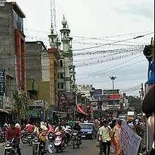
Punjai Puliampatti workers are mostly employed in the primary and secondary sectors. The workforce is made up of about 42% industry workers, 18% in small industries (small scale and cottage industries), 12% in agriculture and 28% in trading or other activities.
.jpg)
There are major industries within the jurisdiction of the local body. The town also serves as an important source of supply for agricultural inputs such as tobacco for the adjoining areas.
Places of interest
There is an old hill temple dedicated to Lord Muruga at Othimalai, 8 km (5.0 mi) from the town center. At 2 km (1.2 mi) from the town there is another temple—Karivaradharaja Perumal— at Puliampatti on the way to Tiruppur.
The nearest well known temple, Bannari Amman Temple in Bannari is 28 km (17 mi) from the town, where a Fire Walking Ceremony is held in March/April every year. Bhavanisagar dam or Lower Bhavani Dam is a distance of 16 km (9.9 mi) from the town, via Sultan Road (Bavanisagar Road) from Puliampatti. It is one of the world's largest earthen dams. The Kodiveri dam water falls on the Bhavani river are 27 km (17 mi) from town. Dhimbam ghat on Mysore road (NH 209) contains a reserve forest, the Sathyamangalam Wildlife Sanctuary 40 km (25 mi) away.
Cinema centres:
- Sri Devi multiplex theater (3 screens) N.H.948 Covai-Banglore main road
Economy
The main source of income for Punjai Puliampatti comes from trading and small businesses along with agriculture. There are also many spinning mills and weaving units in and around the town. Others commute to nearby Coimbatore for work and education. It is an industrial area that includes around 70 textile mills. The workforce is made up of about 42% industry workers, 18% in small industries (small scale and cottage industries), 12% in agriculture and 28% in trading or other activities. There are major industries within the jurisdiction of the local body.
Weekly market
It has a weekly shandy (market) covering an area is 45 acres which brings in annual income of 40 lakhs for the municipality. The total area of the sandy is about 45 acres that makes it one of the largest weekly markets in Tamilnadu.[7] The cattle market starts Wednesday and ends on Thursday every week and the sales goes around 2 crores on that day.[8]
Educational and Health centres
Schools:
- KVK Government Boys Higher Secondary School, Anna Nagar
- Government Girls Higher Secondary School, Ramanathapuram
- Government Higher Secondary School, Panayampalli .
- SRC Memorial Matriculation School, Nallur
- Old S R C Memorial Matriculation School, Sowdeswari Kovil Street
- Amma Matric Hr. Sec. School, Maraimali Adigal Street
- M.M.E. Gurukulam Higher Secondary School, Thapovanam
- Bhavani Higher Secondary School, Sellappampalayam
- Panchayat Union Primary School, Sathiram Road
- Government Elementary School, NH948
- Chinthamani Vidyalaya School, thiru.v.ka.thidal
- K.G. Nursery & Primary School, Laxmi Nagar, Ramanadhapuram
- SNR Higher Secondary School Vinnapalli
- Springdale Public School
- Chanakya International School
There are also a number of primary school campuses in and around Puliampatti.
Colleges:
- Ayyan Thiruvalluvar College of Arts and Science, Sellappampalayam
- Gandhi Polytechnic College, Vinnapalli
- Kannappar Private Industrial Training Institute, Kalippalayam, P. Puliampatti
Health centres:
- Anbu Hospital, Hospital road
- PG Hospital, Hospital road
- Government Hospital - upgraded primary health centre, Sathy Road
- Arunachalam Hospital, NH948
- Muthu Hospital, Thiru v ka thidal
- Vishnu Hospital, Mathampalayam road
- Mani Hospital, Sultan Road
- Devi Hospital, Sultan Road
- Suman Dental Clinic, E 4th Street
- Visalakshi Dental Hospital, Mathampalayam Road
- Aravind Eye Clinic, Mathampalayam road
- Apollo Pharmacy, NH948
- Cura Pharmacy, NH948
- MedPlus Pharmacy, Bhavanisagar Bannari Road,
- Women Care Clinic near Nagaratchi Thirumanamandapam,
There are also a number of small hospitals and clinics in Puliampatti.
Banks And ATMs
•Indian overseas bank NH 948
•SBI madhampalayam road
•City Union Bank madhampalayam road,
•Andra Bank madhampalayam road
•TMB madhampalayam road kannappar mahal near.
•KVB Bhavanisagar road
•Canara Bank N.H 948 covai road
•Federal Bank N.H 948 sathy road
•Jana Bank opp to vishnu tvs N.H 948
•EDCC Bank near vishnu tvs N.H 948
•Tamilnadu Grama Bank (Pallavan) N.H. 948
ATM & CDM
• IOB ATM & CDM (near branch)
•SBI ATM & CDM (near Branch) additional ATM @ Sathy road
•City Union Bank ATM & CDM (Near branch)
•Andra Bank ATM & CDM (Near branch)
• TMB ATM (near Branch) additional ATM @ madampalayam road corner.
•KVB ATM & CDM (near branch)
•Canara Bank ATM (near branch)
•ICICI (ATM only) sultan road
•Axis Bank (ATM only) Madampalayam road corner
•India one (ATM only) naal road
Yatra crematorium

Yatra Crematorium in Punjai Puliampatti municipality is located on Puliampatti-Kuttagam Rd, 1 km (0.62 mi) from Puliampatti.
Government offices
| Title | punjai puliampatti |
|---|---|
| post office | Sub Post office |
| pin code | 638459 |
| Telephone | 04295-267091 |
| District | Erode |
| Postal Division | Tirupur |
| Postal region | Coimbatore |
| Postal circle | Tamil nadu |
- Municipality Office, NH 948
- Police Station, NH 948
- Post Office, Nambiyur corner
- Department of Agriculture Marketing, Sathy road
- Sub Register Office, Raja Street
- MLA Office, Covai Road
- Revenue Inspector, RI Office, Nambiyur corner
Post offices under Puliampatti pincode 638459: Sellappampalayam, Karapadi, Mudukkanthurai, Desipalayam, Mathampalayam, Nallur, Nochikuttai, Panniyampalli, Ambothi, Kanvakkarai, Irumborai, Mooduthurai, Pongalur, Pungampalli, Marayeepalayam, Marampalayam, and Uilampalayam.
References
- https://www.thehindu.com/news/cities/Coimbatore/highways-department-to-widen-kalapatti-road/article26135537.ece. Missing or empty
|title=(help) - Falling Rain Genomics, Inc - Punjai Puliampatti
- "Census Info 2011 Final population totals". Office of The Registrar General and Census Commissioner, Ministry of Home Affairs, Government of India. 2013. Retrieved 26 January 2014.
- "Census Info 2011 Final population totals - Punjaipuliampatti". Office of The Registrar General and Census Commissioner, Ministry of Home Affairs, Government of India. 2013. Retrieved 26 January 2014.
- "Population By Religious Community - Tamil Nadu" (XLS). Office of The Registrar General and Census Commissioner, Ministry of Home Affairs, Government of India. 2011. Retrieved 13 September 2015.
- "Welcome to Puliampatty Municipality-Bus and Rail timetable". Department Of Municipal Administration And Water Supply. 17 March 2018. Retrieved 17 March 2018.
- "Punjai Puliampatti". Thanthi TV. 6 September 2018. Retrieved 6 September 2019 – via Youtube.
- "Welcome to Puliampatty Municipality- market". Department Of Municipal Administration And Water Supply. 17 March 2018. Retrieved 17 March 2018.