Whites Creek (Annandale)
Whites Creek, formerly known as White's Creek, was once a natural waterway that was concreted to improve sanitation.[1] The creek is now a heritage–listed artificial waterway located in the inner–west region of Sydney, New South Wales, Australia.
| Whites | |
|---|---|
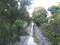
 Whites Creek near the corner of Brennan Street and Railway Parade, Annandale | |
| Etymology | John White |
| Location | |
| Country | Australia |
| State | New South Wales |
| Region | Inner West |
| Local government area | Inner West Council |
| Physical characteristics | |
| Source | Hamond Hill Farm |
| ⁃ location | Annandale |
| Mouth | Rozelle Bay |
⁃ coordinates | 33°52′26.3″S 151°10′10.0″E |
| Basin features | |
| River system | Port Jackson |
| Designation | New South Wales State Heritage Register |
Course and features
Sanitation was poor in the first 100 years of the new colony, and the waterways were contaminated. The waterway was concreted and became a Whites Creek Channel between 1898 and 1935, to cope with the runoff from the increasing amount of impermeal surfaces that. The Whites Creek storm drain as it is now, is located in flows in a northerly direction into Rozelle Bay, part of the Sydney Harbour.[2]
In 1898, an aqueduct was built to carry the sewerage over Whites Creek. This was the first use of the Monier system of reinforced concrete in Australia.[3]
Wetlands were constructed adjacent to the Whites Creek Channel in 2002, to filter out excess nutrients and improve the quality of water flowing into the harbour.[1]
Etymology
Whites Creek is named in honour of John White, the surgeon to the First Fleet. White received a land grant, which he named Hamond Hill Farm, to the south of Parramatta Road, where Whites Creek has its source.[4][5]
Gallery
 Whites Creek at Piper Street, Annandale
References
- "Whites Creek Valley Park". Parks and Playgrounds. Inner West Council. Retrieved 17 July 2017.
- "Whites Creek Stormwater Channel No 95". Sydney Water. 1 January 2000. Retrieved 17 July 2017.
- "Whites Creek Sewage Aqueduct". Sydney Water. 1 January 2000. Retrieved 17 July 2017.
- Rienits, Rex (1967). "White, John (1756–1832)". Australian Dictionary of Biography. 2. Melbourne University Press. ISSN 1833-7538. Retrieved 17 July 2017 – via National Centre of Biography, Australian National University.
- Goodall, R. W. (surveyor); Bemi, P. L. (surveyor). Map of the Estate named Annandale situate in the Parish of Petersham and District of Sydney the property of Robert Johnston Esq. R.N. (Album view) (Map). State Library of New South Wales. Retrieved 17 July 2017.