Douglas County, Nevada
Douglas County is a county in the northwestern part of the U.S. state of Nevada. As of the 2010 census, the population was 46,997.[1] Its county seat is Minden.[2]
Douglas County | |
|---|---|
| Douglas County | |
 Douglas County Courthouse in Minden | |
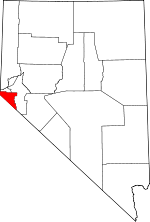 Location within the U.S. state of Nevada | |
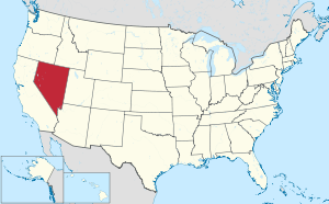 Nevada's location within the U.S. | |
| Coordinates: 38°55′N 119°37′W | |
| Country | |
| State | |
| Founded | 1861 |
| Named for | Stephen A. Douglas |
| Seat | Minden |
| Largest city | Gardnerville Ranchos |
| Area | |
| • Total | 738 sq mi (1,910 km2) |
| • Land | 710 sq mi (1,800 km2) |
| • Water | 28 sq mi (70 km2) 3.8% |
| Population (2010) | |
| • Total | 46,997 |
| • Estimate (2019) | 48,905 |
| • Density | 64/sq mi (25/km2) |
| Time zone | UTC−8 (Pacific) |
| • Summer (DST) | UTC−7 (PDT) |
| Congressional district | 2nd |
| Website | douglascountynv |
Douglas County comprises the Gardnerville Ranchos, NV Micropolitan Statistical Area, which is also included in the Sacramento–Arden-Arcade–Yuba City, CA–NV Combined Statistical Area.
History
The town of Genoa in Douglas County was the first permanent settlement in Nevada. Genoa was settled in 1851 by Mormon traders selling goods to settlers on their way to California. Named for Stephen A. Douglas,[3] famous for his 1860 Presidential campaign and debates with Abraham Lincoln, Douglas County was one of the first nine counties formed in 1861 by the Nevada territorial legislature.
The county seat is Minden, after having been moved from Genoa in 1915.
Various services run by the county include parks, law enforcement, road maintenance, building inspection, and the Minden-Tahoe Airport.
Fire protection and emergency medical services are provided by the Tahoe-Douglas Fire Protection District at the lake and the East Fork Fire Protection District for the rest of the county.
Geography
According to the U.S. Census Bureau, the county has an area of 738 square miles (1,910 km2), of which 710 square miles (1,800 km2) is land and 28 square miles (73 km2) (3.8%) is water.[4] It is the second-smallest county in Nevada by area. The highest point is East Peak at 9,593 ft (2,924 m), while the most topographically prominent mountain is Mount Siegel.
Douglas County is in western Nevada in the western United States. Stretching from Carson Valley and running up into the Sierra Nevada, the county is bordered on the west by California, and contains about 13.2% of Lake Tahoe, which is split across the two states. Carson City, the state capital, lies to the north, and Lyon County to the east.
Major highways
Adjacent counties and city
- Carson City – north
- Lyon County – east
- Mono County, California – southeast
- Alpine County, California – south
- El Dorado County, California – west
- Placer County, California – northwest
National protected area
- Toiyabe National Forest
Demographics
| Historical population | |||
|---|---|---|---|
| Census | Pop. | %± | |
| 1870 | 1,215 | — | |
| 1880 | 1,581 | 30.1% | |
| 1890 | 1,551 | −1.9% | |
| 1900 | 1,534 | −1.1% | |
| 1910 | 1,895 | 23.5% | |
| 1920 | 1,825 | −3.7% | |
| 1930 | 1,840 | 0.8% | |
| 1940 | 2,056 | 11.7% | |
| 1950 | 2,029 | −1.3% | |
| 1960 | 3,481 | 71.6% | |
| 1970 | 6,882 | 97.7% | |
| 1980 | 19,421 | 182.2% | |
| 1990 | 27,637 | 42.3% | |
| 2000 | 41,259 | 49.3% | |
| 2010 | 46,997 | 13.9% | |
| Est. 2019 | 48,909 | [5] | 4.1% |
| U.S. Decennial Census[6] 1790-1960[7] 1900-1990[8] 1990-2000[9] 2010-2018[1] | |||
2000 census
As of the census[10] of 2000, there were 41,259 people, 16,401 households, and 11,890 families living in the county. The population density was 58 people per square mile (22/km2). There were 19,006 housing units at an average density of 27 per square mile (10/km2). The racial makeup of the county was 91.9% White, 0.3% Black or African American, 1.7% Native American, 1.3% Asian, 0.2% Pacific Islander, 2.5% from other races, and 2.2% from two or more races. 7.4% of the population were Hispanic or Latino of any race.
There were 16,401 households, out of which 30.7% had children under the age of 18 living with them, 60.5% were married couples living together, 8.0% had a female householder with no husband present, and 27.5% were non-families. 20.7% of all households were made up of individuals, and 6.6% had someone living alone who was 65 years of age or older. The average household size was 2.50 and the average family size was 2.88.
In the county, the population was spread out, with 24.0% under the age of 18, 5.5% from 18 to 24, 26.4% from 25 to 44, 28.9% from 45 to 64, and 15.2% who were 65 years of age or older. The median age was 42 years. For every 100 females there were 102.1 males. For every 100 females age 18 and over, there were 100.7 males.
The median income for a household in the county was $51,849, and the median income for a family was $57,092. Males had a median income of $40,436 versus $28,762 for females. The per capita income for the county was $27,288. About 5.8% of families and 7.3% of the population were below the poverty line, including 9.7% of those under age 18 and 5.3% of those age 65 or over.
2010 census
As of the 2010 United States Census, there were 46,997 people, 19,638 households, and 13,519 families living in the county.[11] The population density was 66.2 inhabitants per square mile (25.6/km2). There were 23,671 housing units at an average density of 33.4 per square mile (12.9/km2).[12] The racial makeup of the county was 89.6% white, 1.9% Native American, 1.5% Asian, 0.4% black or African American, 0.1% Pacific islander, 3.2% from other races, and 3.1% from two or more races. Those of Hispanic or Latino origin made up 10.9% of the population.[11] In terms of ancestry, 25.7% were German, 17.5% were English, 14.9% were Irish, 8.0% were Italian, and 4.1% were American.[13]
Of the 19,638 households, 26.7% had children under the age of 18 living with them, 55.5% were married couples living together, 8.9% had a female householder with no husband present, 31.2% were non-families, and 24.0% of all households were made up of individuals. The average household size was 2.38 and the average family size was 2.80. The median age was 47.4 years.[11]
The median income for a household in the county was $60,721 and the median income for a family was $73,543. Males had a median income of $52,001 versus $39,825 for females. The per capita income for the county was $35,239. About 5.4% of families and 7.9% of the population were below the poverty line, including 10.8% of those under age 18 and 6.1% of those age 65 or over.[14]
Communities
Census-designated places
There are no incorporated towns or cities in Douglas County. The following communities are census-designated places, meaning population and demographic data is available from the U.S. Census Bureau for each one:
Unincorporated communities
- Buckeye
- Centerville
- Dresslerville
- Hobart
- Holbrook Junction
- Jack's Valley
- Lake Village
- Lincoln Park
- Mottsville
- Mountain House
- Ranchos
- Sheridan
- Spooner Junction
- Summit Village
- Tahoe Village
Politics
Historically Douglas was the most Republican county in Nevada, a state that tended to lean Democratic between the 1890s and 1950s. It was the only Nevada county won by Charles Evans Hughes in 1916, and one of only two to vote for Progressive “Bull Moose” ex-President Theodore Roosevelt in 1912. It was also one of only two Nevada counties that voted for incumbent President Benjamin Harrison over insurgent Populist James B. Weaver in 1892 when the latter carried the state by over forty percentage points, and when Douglas did vote Democratic in 1896 and 1900 it was by much smaller margins than the rest of silver-mining Nevada.[15]
The county remains a Republican strong hold.. The last Democrat to carry Douglas County was Franklin D. Roosevelt in 1936 during his 46-state landslide over Alf Landon, and even then FDR received fifteen percent less than his statewide vote share. Apart from FDR‘s two 1930s wins, Lyndon Johnson in 1964 – when it was one of three Nevada counties to vote for Barry Goldwater – and Barack Obama in 2008 have been the sole Democrats to pass forty percent of the county’s vote since 1920.
| Year | Republican | Democratic | Third parties |
|---|---|---|---|
| 2016 | 62.5% 17,415 | 30.3% 8,454 | 7.2% 2,016 |
| 2012 | 62.4% 16,276 | 35.7% 9,297 | 1.9% 502 |
| 2008 | 56.6% 14,648 | 41.2% 10,672 | 2.3% 584 |
| 2004 | 63.6% 15,192 | 34.6% 8,275 | 1.8% 431 |
| 2000 | 62.3% 11,193 | 32.5% 5,837 | 5.3% 944 |
| 1996 | 54.8% 8,828 | 31.7% 5,109 | 13.4% 2,163 |
| 1992 | 40.8% 6,182 | 25.9% 3,928 | 33.3% 5,035 |
| 1988 | 67.0% 7,074 | 29.4% 3,107 | 3.5% 374 |
| 1984 | 75.6% 6,385 | 22.2% 1,877 | 2.2% 187 |
| 1980 | 71.6% 5,254 | 18.4% 1,352 | 10.0% 737 |
| 1976 | 58.6% 3,095 | 36.6% 1,934 | 4.8% 253 |
| 1972 | 74.7% 2,898 | 25.3% 983 | |
| 1968 | 64.4% 1,801 | 24.0% 670 | 11.7% 327 |
| 1964 | 52.7% 1,127 | 47.3% 1,010 | |
| 1960 | 66.5% 1,164 | 33.5% 587 | |
| 1956 | 80.6% 1,063 | 19.4% 256 | |
| 1952 | 84.3% 948 | 15.7% 177 | |
| 1948 | 69.7% 719 | 28.9% 298 | 1.5% 15 |
| 1944 | 66.4% 556 | 33.7% 282 | |
| 1940 | 64.2% 592 | 35.8% 330 | |
| 1936 | 42.6% 346 | 57.4% 466 | |
| 1932 | 45.4% 331 | 54.6% 398 | |
| 1928 | 71.0% 456 | 29.0% 186 | |
| 1924 | 59.0% 343 | 16.4% 95 | 24.6% 143 |
| 1920 | 76.7% 503 | 22.4% 147 | 0.9% 6 |
| 1916 | 48.7% 337 | 43.5% 301 | 7.8% 54 |
| 1912 | 19.2% 80 | 34.3% 143 | 46.5% 194 |
| 1908 | 54.7% 229 | 41.3% 173 | 4.1% 17 |
| 1904 | 68.6% 262 | 29.3% 112 | 2.1% 8 |
Economy
Major employers
- Starbucks roasting plant
- Patmont Motor Werks
- Bently Nevada, part of Baker Hughes
- North Sails
- TeslaWatt
Education
Douglas County's education is managed by the Douglas County School District. It serves for all of Douglas County, having two main areas: Lake Tahoe & the Carson Valley. Douglas High School also serves most of the high school age students from Alpine County, California
Lake Tahoe
- George Whittell High School
- Zephyr Cove Elementary School
Carson Valley
- Douglas High School
- Aspire Academy High School
- Carson Valley Middle School
- Pau-Wa-Lu Middle School
- Gardnerville Elementary School
- Minden Elementary School
- Jacks Valley Elementary School
- Piñion Hills Elementary School
- Gene L. Scarselli Elementary School
- C.C. Meneley Elementary School
Private schools
- Sierra Lutheran High School
- Faith Christian Academy
- Grace Christian Academy
In popular culture
- Smokin Aces
- Charley Varrick
- The Shootist
- Misery
- The Motel Life
References
- "State & County QuickFacts". United States Census Bureau. Archived from the original on June 6, 2011. Retrieved September 23, 2013.
- "County Explorer". National Association of Counties. Retrieved June 7, 2011.
- Gannett, Henry (1905). The Origin of Certain Place Names in the United States. Govt. Print. Off. p. 108. Retrieved January 1, 2016.
- "2010 Census Gazetteer Files". United States Census Bureau. August 22, 2012. Retrieved December 20, 2014.
- "Population and Housing Unit Estimates". Retrieved May 18, 2019.
- "U.S. Decennial Census". United States Census Bureau. Retrieved December 20, 2014.
- "Historical Census Browser". University of Virginia Library. Retrieved December 20, 2014.
- "Population of Counties by Decennial Census: 1900 to 1990". United States Census Bureau. Retrieved December 20, 2014.
- "Census 2000 PHC-T-4. Ranking Tables for Counties: 1990 and 2000" (PDF). United States Census Bureau. Retrieved December 20, 2014.
- "U.S. Census website". United States Census Bureau. Retrieved January 31, 2008.
- "DP-1 Profile of General Population and Housing Characteristics: 2010 Demographic Profile Data". United States Census Bureau. Archived from the original on 2020-02-13. Retrieved 2016-01-21.
- "Population, Housing Units, Area, and Density: 2010 - County". United States Census Bureau. Archived from the original on 2020-02-13. Retrieved 2016-01-21.
- "DP02 Selected Social Characteristics in the United States – 2006–2010 American Community Survey 5-Year Estimates". United States Census Bureau. Archived from the original on 2020-02-13. Retrieved 2016-01-21.
- "DP03 Selected Economic Characteristics – 2006–2010 American Community Survey 5-Year Estimates". United States Census Bureau. Archived from the original on 2020-02-13. Retrieved 2016-01-21.
- Robinson, Edgar Eugene; The Presidential Vote; 1896–1932 (second edition); pp. 268–270 Published 1947 by Stanford University Press
- Leip, David. "Dave Leip's Atlas of U.S. Presidential Elections". uselectionatlas.org. Retrieved 2018-04-12.
External links
- Official website
- The Record Courier – Local Newspaper
- Carson Valley Chamber of Commerce & Visitors Authority
- Douglas County School District
- Carson Valley Area Weather
Places adjacent to Douglas County, Nevada | |
|---|---|
Municipalities and communities of Douglas County, Nevada, United States | ||
|---|---|---|
| CDPs | Douglas County map | |
| Unincorporated communities | ||
| Authority control |
|
|---|