Cameron Park, California
Cameron Park is a census-designated place (CDP) in El Dorado County, California, United States and is part of the Sacramento metropolitan area. The population was 18,228 at the 2010 census, up from 14,549 at the 2000 census. Cameron Park is a community located in the Northern California Gold Country of the Sierra Nevada foothills, approximately 30 miles (50 km) east of Sacramento and 70 miles (110 km) west of South Lake Tahoe.
Cameron Park, California | |
|---|---|
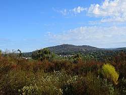 Panoramic view of Cameron Park | |
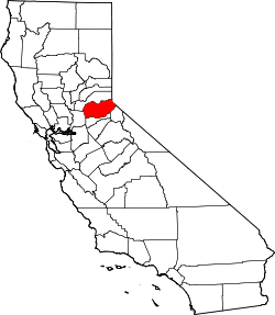
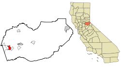 Location in El Dorado County and the state of California | |
 Cameron Park, California Location in the United States | |
| Coordinates: 38°40′08″N 120°59′14″W | |
| Country | |
| State | |
| County | El Dorado |
| Area | |
| • Total | 28.945 km2 (11.176 sq mi) |
| • Land | 28.766 km2 (11.107 sq mi) |
| • Water | 0.179 km2 (0.069 sq mi) 0.62% |
| Elevation | 365 m (1,198 ft) |
| Population (2010) | |
| • Total | 18,228 |
| • Density | 630/km2 (1,600/sq mi) |
| Time zone | UTC-8 (Pacific (PST)) |
| • Summer (DST) | UTC-7 (PDT) |
| ZIP code | 95682 |
| Area code(s) | 530 |
| FIPS code | 06-10256 |
| GNIS feature ID | 1733968 |
History
The original Native American inhabitants of the area surrounding Cameron Park were Nisenan, or Southern Maidu Indians. Grinding rocks and burial mounds serve as glimpses of the past and are still visible in various locations in and near Cameron Park.
Modern development accelerated in the area when Larry Cameron purchased 5,000 acres (2,000 ha) of foothill land in the 1950s for development purposes, first for ranching, then involving housing, a golf course, parks, a lake and a small airport. In the years since then, the land has slowly been sub-divided into lots of varying sizes, including ranch-sized properties and medium and high density residential neighborhoods. Today, Cameron Park contains a mix of ranches, single family homes, condominiums, apartments and businesses.[2]
Geography and climate
According to the United States Census Bureau, the CDP has a total area of 11.2 square miles (29 km2), of which 11.1 square miles (29 km2) is land and 0.1 square miles (0.26 km2) (0.62%) is water.
Cameron Park is situated in an interior Chaparral zone or brush zone just east of the Central Valley (California). It is the closest population center to the Pine Hill Ecological Reserve. Native vegetation includes an abundance of redbud and manzanita bushes, and brush in general. Where treed the native trees are primarily gray pines, and oak trees with some small groves of ponderosa pines starting in the higher elevation zones. The elevation of Cameron Park varies between approximately 1,200 and 1,450 feet (370 and 440 m) above sea level, and is not considered in the snow zone of the Sierra Nevada mountains to the east, which is typically between 3,000 and 5,000 feet of elevation and above.
Summers are generally hot and dry, with average daytime temperatures in the 90 to 100 °F (32 to 38 °C) range, but sometimes reaching 110 °F (43 °C), or more. It can be very dry, with little effect of mountain thunderstorms or monsoonal flows that affect the south and interiors. Nights, however, tend to cool off more so than in the Sacramento Valley below, and temperatures in general range a few degrees below the eastern portion of the Central Valley because of the elevation difference. Autumns tend to be an "extended dry, hot summer" throughout California and Cameron Park is no exception. Winters are generally cool and rainy, with highs averaging 40 to 60 °F (4 to 16 °C) and nights occasionally dropping below freezing. Cameron Park typically receives exceptional snow events, about once every few years.
The soil in Cameron Park is reddish and clay-like and usually must be amended in order for many non-native ornamental plants to survive. The soil is derived from Gabbro type of volcanic bedrock and despite its clay-like composition it is good soil and rich in nutrients. Cameron Park is in Sunset Climate Zone 9 and USDA Plant Hardiness Zone 9A.
Demographics
| Historical population | |||
|---|---|---|---|
| Census | Pop. | %± | |
| U.S. Decennial Census[3] | |||
2010 census data
At the 2010 census Cameron Park had a population of 18,228. The population density was 1,631.0 people per square mile (629.7/km2). The racial makeup of Cameron Park was 16,242 (89.1%) White, 143 (99.8%) African American, 194 (1.1%) Native American, 425 (2.3%) Asian, 36 (0.2%) Pacific Islander, 461 (2.5%) from other races, and 727 (4.0%) from two or more races. Hispanic or Latino of any race were 2,056 persons (11.3%).[4]
The census reported that 18,222 people (100% of the population) lived in households, 6 (0%) lived in non-institutionalized group quarters, and no one was institutionalized. 2,512 (35.9%) households had children under the age of 18 living with them, 3,975 (56.8%) were opposite-sex married couples living together, 790 (11.3%) had a female householder with no husband present, 356 (5.1%) had a male householder with no wife present. There were 390 (5.6%) unmarried opposite-sex partnerships, and 41 (0.6%) same-sex married couples or partnerships. 1,465 households (20.9%) were one person and 622 (8.9%) had someone living alone who was 65 or older. The average household size was 2.61. There were 5,121 families (73.2% of households); the average family size was 3.00.
The age distribution was 4,576 people (25.1%) under the age of 18, 1,502 people (8.2%) aged 18 to 24, 4,162 people (22.8%) aged 25 to 44, 5,358 people (29.4%) aged 45 to 64, and 2,630 people (14.4%) who were 65 or older. The median age was 40.6 years. For every 100 females, there were 94.3 males. For every 100 females age 18 and over, there were 92.1 males.
There were 7,610 housing units at an average density of 680.9 per square mile (262.9/km2), of which 6,993 were occupied, 4,768 (68.2%) by the owners and 2,225 (31.8%) by renters. The homeowner vacancy rate was 2.0%; the rental vacancy rate was 14.6%. 12,566 people (68.9% of the population) lived in owner-occupied housing units and 5,656 people (31.0%) lived in rental housing units.
2000 census data
At the 2000 census there were 14,549 people, 5,537 households, and 4,147 families in the CDP. The population density was 1,975.8 people per square mile (763.2/km2). There were 5,703 housing units at an average density of 774.5 per square mile (299.2/km2). The racial makeup of the CDP was 92.25% White, 0.63% Black or African American, 0.89% Native American, 1.44% Asian, 0.12% Pacific Islander, 1.88% from other races, and 2.80% from two or more races. 6.70% of the population were Hispanic or Latino of any race.[5] Of the 5,537 households 37.4% had children under the age of 18 living with them, 59.9% were married couples living together, 10.9% had a female householder with no husband present, and 25.1% were non-families. 19.2% of households were one person and 7.0% were one person aged 65 or older. The average household size was 2.63 and the average family size was 3.00.
The age distribution was 27.1% under the age of 18, 7.3% from 18 to 24, 29.1% from 25 to 44, 24.3% from 45 to 64, and 12.3% 65 or older. The median age was 38 years. For every 100 females, there were 95.4 males. For every 100 females age 18 and over, there were 91.7 males.
The median household income was $59,678 and the median family income was $66,279. Males had a median income of $51,002 versus $34,897 for females. The per capita income for the CDP was $26,677. About 3.7% of families and 5.0% of the population were below the poverty line, including 7.5% of those under age 18 and 1.3% of those age 65 or over.
Government
In the state legislature, Cameron Park is in the 1st Senate District, represented by Republican Brian Dahle,[6] and the 6th Assembly District, represented by Republican Kevin Kiley.[7]
Federally, Cameron Park is in California's 4th congressional district, represented by Republican Tom McClintock.[8]
Locally, a Community Services District (CSD), supported by an elected Board of Directors, provides many programs and services such as fire and emergency services, local administration, CC&R enforcement, recreational programs and parks and facilities management and upkeep.
Sites of interest
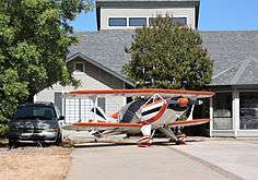
Cameron Airpark Estate's wide streets double as taxiways leading from the residences to the adjacent airport. Many homes have aircraft hangars (oversized garages) that house personal aircraft, allowing residents to commute from home to work entirely by air. The adjoining airport (Cameron Airpark, O61) is a public airport and of economic importance to the surrounding region.

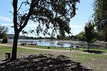
Adjacent to the Airpark Estates sits man-made Cameron Park Lake. Covering approximately 10 acres (4 ha), the area contains a trail encircling the lake, picnic areas, boat rentals, tennis courts, playgrounds, as well as a sandy beach and swimming area separated from the main lake by an earthen dam. Turtles and aquatic fowl can be seen at the lake, and the Community Services District regularly stocks the lake with fish including bluegill, black bass, and black crappie fish. Cameron Park Lake is also the site of the annual "Summer Spectacular" held on or about the Independence Day holiday. Since 1999 this event has provided entertainment, food, and a fireworks show to attendees. Cameron Park Lake is also the home of "Ribstock," a one-day barbecue festival that features a Kansas City Barbeque Society-sanctioned barbecue competition.
Cameron Park was once known as the home of "Sam's Town", where many travelers stopped on their way to and from Lake Tahoe. This restaurant and amusement complex was located along Highway 50, but was torn down in 2002 and is now a "ForkLift Grocery" store, part of the Nugget Markets chain. All that remains is a plaque noting its former existence.
Parts of the Skinner Vineyard and Winery from the early 1860s can be seen at the intersection of Green Valley Road and Cameron Park Drive. All that is left of Skinner's ranch is a portion of the cellar (integrated into the Cameron Park Nursery on the northeast corner of the intersection), a tiny remnant of the distillery wall (behind mobile homes in the mobile home park near the southeast corner of the intersection), and the Skinner cemetery (near the south-west corner of the intersection). The cemetery contains the graves of James and Jessie Skinner (née Bernard) and three of their sons. The cemetery is located on a small hill just west of the intersection behind a pizza restaurant. Only remnants of a few headstones and fence remain due to the effects of time and vandalism. There are several other "pioneer" cemeteries located throughout Cameron Park.
El Dorado Community Health Center (EDCHC) is a Federally Qualified Health Center 501(c)(3) with a wide range of services in Cameron Park, CA, including; General Health, Dental Services, Pharmacy, Prevention & Wellness, Immunizations, Behavioral Health, Podiatry and Flu/Pneumonia Immunization.
References
- U.S. Census Archived 2012-07-02 at the Wayback Machine
- "Archived copy". Archived from the original on 2017-01-04. Retrieved 2017-01-03.CS1 maint: archived copy as title (link)
- "Census of Population and Housing". Census.gov. Retrieved June 4, 2016.
- "2010 Census Interactive Population Search: CA - Cameron Park CDP". U.S. Census Bureau. Archived from the original on July 15, 2014. Retrieved July 12, 2014.
- "U.S. Census website". United States Census Bureau. Retrieved 2008-01-31.
- "Senators". State of California. Retrieved April 5, 2013.
- "Members Assembly". State of California. Retrieved April 5, 2013.
- "California's 4th Congressional District - Representatives & District Map". Civic Impulse, LLC. Retrieved March 2, 2013.
| Wikimedia Commons has media related to Cameron Park, California. |
External links
- Chamber of Commerce
- Community Services District
- Cameron Park Country Club
- El Dorado Community Health Center (EDCHC)
- Ribstock BBQ Festival
- Summer Spectacular
- Foothill Cruiser Car Show
- Run with Santa
| Authority control |
|
|---|