Black Rock Desert
The Black Rock Desert is a semi-arid region (in the Great Basin shrub steppe eco-region), of lava beds and playa, or alkali flats, situated in the Black Rock Desert–High Rock Canyon Emigrant Trails National Conservation Area, a silt playa 100 miles (160 km) north of Reno, Nevada that encompasses more than 300,000 acres (120,000 ha) of land and contains more than 120 miles (200 km) of historic trails. It is in the northern Nevada section of the Great Basin with a lakebed that is a dry remnant of Pleistocene Lake Lahontan.
| Black Rock Desert | |
|---|---|
 | |
| Length | 100 mi (160 km) |
| Area | 1,000 sq mi (2,600 km2) |
| Geography | |
| Country | United States |
| State | Nevada |
| County | Humboldt, Pershing and Washoe |
| Population center | Gerlach, Nevada |
| Coordinates | 40°52′59″N 119°03′50″W |
| River | Quinn River |
The Great Basin, named for the geography in which water is unable to flow out and remains in the basin, is a rugged land serrated by hundreds of mountain ranges, dried by wind and sun, with spectacular skies and scenic landscapes.[1] The average annual precipitation (years 1971-2000) at Gerlach, Nevada (extreme south-west of the desert) is 7.90 inches (200 mm).[2]
The region is notable for its paleogeologic features, as an area of 19th-century Emigrant Trails to California, as a venue for rocketry, and as an alternative to the Bonneville Salt Flats in northwestern Utah, for setting land speed records (Mach 1.02 in 1997). It is also the location for the annual Burning Man event.
The Black Rock Desert is part of the National Conservation Area (NCA), a unit of the Bureau of Land Management (BLM) National Landscape Conservation System (NLCS). The NCA is located in northwest Nevada, and was established by legislation in 2000. It is a unique combination of desert playa, narrow canyons, and mountainous areas.
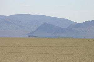
Humans have been in Black Rock Desert since approximately 10,000 B.P.[3] Around 1300 AD the area was settled by the Paiute people.[4][5] The large black rock formation was used as a landmark by the Paiute and later emigrants crossing the area. The landmark is a conical outcrop composed of interbedded Permian marine limestone and volcanic rocks.[6] At its base is a large hot spring and grassy meadow, which was an important place for those crossing the desert headed for California and Oregon. In 1843, John Fremont and his party were the first white men to cross the desert, and his trail was used by over half the 22,000 gold seekers headed to California after 1849. In 1867, Hardin City, a short-lived silver mill town was established (now a ghost town).
Geography


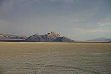
The Black Rock Desert region is in northwestern Nevada and the northwestern Great Basin. The playa extends for approximately 100 mi (160 km) northeast from the towns of Gerlach and Empire, between the Jackson Mountains to the east and the Calico Hills to the west.
The Black Rock Desert is separated into two arms by the Black Rock Range. It lies at an elevation of 3,907 ft (1,191 m)[8] and has an area of about 1,000 sq mi (2,600 km2).[9]
There are several possible definitions of the extent of the Black Rock Desert. Often people refer just to the playa surface. Sometimes terrain which can be seen from the playa is included. The widest definition of the Black Rock Desert region is the watershed of the basin that drains into the playa. The intermittent Quinn River is the largest river in the region, starting in the Santa Rosa Range and ending in the Quinn River Sink on the playa south of the Black Rock Range. The watershed covers 11,600 sq mi (30,000 km2)[10] including the Upper and Lower Quinn River, Smoke Creek Desert, Massacre Lake, and Thousand Creek[11]/Virgin Valley[12] watersheds of northwestern Nevada as well as small parts across the borders of California and Oregon.
If the playa is wet for a month or so, the shallow waters teem with fairy shrimp, or anostraca born of eggs that lie dormant in the silt crust for long periods of time - sometimes for many years. The edges of the playa and the Quinn River Sink stay wet longer than the rest of the playa, which concentrates the fairy shrimp and migratory birds in those areas. More than 250 species of neo-tropical migrant birds and many other water birds stop in Black Rock-High Rock Country for varying lengths of time. When wet, especially in spring, the playa is a favorite place for these winged visitors to rest and feed.[1]
When it rains, the playa can become extremely sticky, bogging down four-wheel-drive vehicles. Some areas of the Black Rock are environmentally sensitive and closed to all vehicles.
Humboldt, Pershing and Washoe Counties of Nevada intersect at the Black Rock Desert.
Mountain ranges
The following mountain ranges are within or bordering the Black Rock Desert region.

- Antelope Range[13]
- Badger Mountains[14]
- Black Rock Range[15]
- Calico Hills[16]
- Division Range[17]
- Fox Range[18]
- Granite Range[19]
- Hannan Range[20]
- High Rock Canyon Hills[21]
- Hog Ranch Mountains[22]
- Jackson Mountains[23]
- Kamma Mountains[24]
- Little High Rock Mountains[25]
- Massacre Range[26]
- Montana Mountains[27]
- Pine Forest Range[28]
- Poker Brown Mountains[29]
- Selenite Range[30]
- Sentinel Hills[31]
- Seven Troughs Range[32]
- Sheephead Mountains[33]
- Smoke Creek Mountains[34]
- Yellow Hills[35]
Geologic features
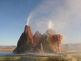
The desert has numerous volcanic and geothermal features of the northwest Nevada volcanic region, including two Black Rock Points (west and east) at the southern end of the Black Rock Range and which have dark Permian volcanic rocks similar to another Permian black diabase dike formation in Nevada.[36]
The portion of the Lake Lahontan lakebed in the Black Rock Desert is generally flat with Lahontan salt shrub vegetation, widely scattered hot springs, and a playa. In areas of the lakebed along mountains, rain shadow results in desert precipitation levels.
The playa of the Black Rock Desert lakebed is ~200 sq mi (520 km2) within an area bounded by the Calico Mountains Wilderness (north), Gerlach (west), the Applegate National Historic Trail (northeast), and the Union Pacific Railroad (south).[39] The "South Playa" (~30 sq mi, with ~13 sq mi (34 km2) in Washoe Co) is between Gerlach and the southwest boundary of the National Conservation Area (NCA),[39] while the northeast NCA portion of the playa (including ~25 sq mi (65 km2) in Humboldt Co) is between the NCA boundary and the Applegate National Historic Trail.[39] A Nobles route between Gerlach and Black Rock Hot Springs extends through the length of the playa.[39] The playa's Quinn River Sink of ~3 sq mi (7.8 km2) is where the Quinn River discharges/evaporates ~2.75 mi (4.43 km) south-southwest of Black Rock Hot Springs.[40]
Mining
Prospecting and mining has occurred in the Black Rock region since the mid-19th century. US Gypsum Corporation operated a gypsum mine and drywall (brand named Sheetrock) manufacturing plant in Empire, which employed 107 people and produced 266,300 tons of gypsum in 2008.[41][42]
Allied Nevada Gold Corporation re-opened the Hycroft Gold Mine in 2008 after acquiring it from Vista Gold Corp. Hycroft is a strip-mining operation in the Kamma Mountains near Sulphur on the east side of the Black Rock Desert.[41][43][44] An opal mine is in the base of the Calico Hills on the west side of the desert.[45]
Paleontology
Bones of the mammoths that roamed the area around 20,000 BC have been recovered.[46] In 1979 a fossilized Columbian Mammoth was found.[47][48] Copies of the bones are now exhibited at the Nevada State Museum, Carson City.
Land speed records
The flatness of the Black Rock Desert's lakebed surface has led to the area's use as a proving ground for experimental land vehicles. It was the site of two successful attempts on the world land speed record:
- In 1983, Richard Noble drove the jet-powered Thrust2 car to a new record of 634.015 mph (1,020.348 km/h). Noble also headed up the team that beat the Thrust 2 record.[49]
- In 1997, ThrustSSC driven by Andy Green became the world's first, and so far, the only supersonic car, reaching 763.035 mph (1,227.986 km/h).[50][51]

Rocketry records and attempts
In addition to the flat surface, distance from populated areas and uncontrolled airspace over the area also attract experimentation with rockets. The following are highlights of amateur rocketry records[52] set at Black Rock:
- On November 23, 1996, the Reaction Research Society launched a rocket to 50 miles (80 km) in altitude, a significant leap in amateur rocket altitude records at the time.[52][53]
- On May 17, 2004, the Civilian Space eXploration Team (CSXT) launched a rocket to 72 miles (116 km) in altitude, which was the first amateur rocket to exceed the 62.14-mile (100.00 km) Kármán line required to claim a space flight.[54][55]
Other rocket launches attempting various altitude records or space flights have occurred at Black Rock. In May 1999, JP Aerospace used a rockoon (balloon-launched rocket) in an unsuccessful suborbital space flight attempt covered by CNN. The rocket reached 75,000 feet (23,000 m), which was far less than the intended Karman Line to reach space.[56] CSXT made unsuccessful space launch attempts in 2000 and 2002 before the successful 2004 space flight.[57][58] JP Aerospace returned to the desert in 2009, launching an armchair to the edge of space for Space Chair, an advertisement for Toshiba electronic products.[59] On September 21, 2013, the University of Southern California's Rocket Propulsion Laboratory (USCRPL) launched its first space shot attempt, Traveler, intended to achieve a max altitude of 75 miles (121 km). The rocket experienced a catastrophic failure 3.5 seconds into flight at an altitude of approximately 10,000 feet (3,000 m). If successful, Traveler would have been the first university/student designed and built rocket to exceed the 62.14-mile (100.00 km) Kármán line required to claim a space flight. RPL's second attempt, Traveler II, flew in May 2014. It also failed catastrophically, approximately one second into the flight.[60][61][62][63]
History
More than ~15,000 years ago (15 tya), the Humboldt River flowed to the Smoke Creek-Black Rock Desert sub-basin, and during the recession of Lake Lahontan, the river diverted to the Carson Desert sub-basin.[64] During the highest Lahontan water level (~12.7 tya), the lakebed was under about 500 ft (150 m) of water,[65][66] under which sediment accumulated to form a flat lakebed.
Great Basin tribes inhabited the area approximately 10,000 B.P.,[3] and a Frémont Expedition encountered the site in 1843, but the Fortieth Parallel Survey (1867) conducted the first official exploration.[67] In the late 1840s, Peter Lassen led California Trail emigrants through the desert's Applegate-Lassen Cutoff, an arduous route that took them hundreds of miles away from the gold lands of California. By 1910, Western Pacific's Feather River Route (Oakland-Salt Lake City) had been completed across the east side of the lakebed on the "general route first explored by Lieutenant E.G. Beckwith in 1854".[68] By 1927, the desert had been used for filming The Winning of Barbara Worth (the 2003 Mythbusters pilot episode was also filmed in the area).
In World War II, 973 sq mi (2,520 km2) of the Black Rock Desert was used for a USAAF aerial gunnery training range, and post-war, the north region of the United States Navy's Lovelock Aerial Gunnery Range was in the Black Rock Desert area[69] (the Black Rock Desert Gunnery Range had closed by 1964).[70] In 1979, a fossilized Columbian Mammoth was found along the side of the lakebed.[71]
The first "Balls" rocket event was held at the desert in 1993,[72] and in 1998, the first annual Gerlach Dash glider race from Reno to the desert was held.[73] For its 30th anniversary, the Black Rock Press (University of Nevada, Reno) published a 1994 book of desert photographs.[74] The Friends of the Black Rock/High Rock organized in 1999,[75] and a National Conservation Area Act the next year created several protected areas of the desert.[40]:a Also in 2000, Lisa O'Shea died seven days after being scalded in Double Hot Springs when she attempted to rescue two dogs,[76] and the Bureau of Land Management subsequently fenced "Double Hot".[40]
21st century
Jack Lee Harelson was fined $2.5 million in 2002 for archeological looting of Elephant Mountain Cave, and in 2008, an injured man was rescued when an aircraft pilot radioed for help after noticing him lying face-down on the lakebed.[77] In 2010, the Bureau of Land Management (BLM) Winnemucca District Office completed a roundup of 1,922 wild horses in the Calico Mountains Complex, of which 39 died of malnutrition due to overgrazing.[40]:d[40]:h
From 1990 to 1997, and since 1998, the Black Rock Desert is the annual location for Burning Man.
Transportation
.jpg)
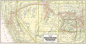
Nevada State Route 447 is the area's main highway and connects Gerlach to SR 427 at Wadsworth, Nevada, near Interstate 80.[78] The desert's dirt roads are generally not usable in wet or snowy conditions. Old Highway 34 provides access to the playa on the west side and to the Hualapai Flat. Old Highway 48 (dirt) connects the playa to Lovelock, and Old Highway 49 (Jungo Road, dirt) provides access to the lakebed from the Sulphur and Jungo ghost towns.[79]
The Feather River Route uses the lakebed's east side between Sulphur and Gerlach. Light aircraft have landed on the lakebed for events (the nearby Empire and Reno-Tahoe International Airports provide commercial service for the area).
References
- "General Information". Friends of Black Rock High Rock. Archived from the original on 2012-09-02. Retrieved 2012-09-01.
- "Climate Normals". Ggweather.com. Retrieved 2014-08-27.
- Connolly, Thomas J.; Barker, Pat; Fowler, Catherine S.; Hattori, Eugene M. (July 2016). "Getting beyond the Point: Textiles of the Terminal Pleistocene/Early Holocene in the Northwestern Great Basin". American Antiquity. 81 (3): 490–514. doi:10.1017/S0002731600003966. Retrieved 2019-06-03.
Elephant Mountain Cave (26HU-3557-sd2), ca. 9700 cal B.P.
- Naval Air Station Fallon Geothermal Energy Development for Generation of Electrical Power, Churchill County: Environmental Impact Statement, Part 2 (Report). United States Navy. p. 114. Retrieved 2019-09-03.
Layton suggests little use of the High Rock Country from ca. AD 200-1300, with the population possibly emigrating to Surprise Valley.
- Wheeler, Sessions S. (1978). The Black Rock Desert. Caxton Press. p. 32. ISBN 978-0-87004-258-4.
When the first white man arrived, the region known as northwestern Nevada was occupied by the Northern Paiute people. Cave excavations have provided evidence that these Indians did not come to this section of the Great Basin until approximately 1,400 A.D. and that at least three other separate cultures of people preceded them.
- "Gianella, V. P., and Larson, E. R., 1960, Marine Permian at Black Rock, Nevada: Geol. Soc. Amer, Abstract of meetings, Vancouver" (PDF). Retrieved 2014-08-27.
- "Black Rock Point". Geographic Names Information System. United States Geological Survey. Retrieved 2009-05-03.
- "Query Form For The United States And Its Territories". U.S. Board on Geographic Names. Retrieved 2010-05-13.
- a,b. "Black Rock Desert (863276)". Geographic Names Information System. United States Geological Survey. Retrieved 2010-01-18., Black Rock Point (838881), Big Mountain (Pahute Peak, 838751)
- c. Wilderness areas: Black Rock Desert (2035060), Calico Mountains (2035079), East Fork High Rock Canyon (2035112), High Rock Canyon (2035154), High Rock Lake (2035155), Little High Rock Canyon (2035182), North Black Rock Range (2035228), North Jackson Mountains (2035230), Pahute Peak (2035240), South Jackson Mountains (2035306)
- Wright, John W. (ed.); et al. (2007) [2006]. The New York Times Almanac. New York, New York: Penguin Books. p. 456. ISBN 978-0-14-303820-7.CS1 maint: extra text: authors list (link)
- "Boundary Descriptions and Names of Regions, Subregions, Accounting Units and Cataloging Units". United States Geological Survey. 2007-04-02. Retrieved 2008-01-11. Cite journal requires
|journal=(help) - "Thousand Creek". Geographic Names Information System. United States Geological Survey. Retrieved 2008-01-13.
- "Virgin Valley". Geographic Names Information System. United States Geological Survey. Retrieved 2008-01-13.
- "Antelope Range". Geographic Names Information System. United States Geological Survey.
- "Badger Mountains". Geographic Names Information System. United States Geological Survey.
- "Black Rock Range". Geographic Names Information System. United States Geological Survey.
- "Calico Hills". Geographic Names Information System. United States Geological Survey.
- "Division Range". Geographic Names Information System. United States Geological Survey.
- "Fox Range". Geographic Names Information System. United States Geological Survey.
- "Granite Range". Geographic Names Information System. United States Geological Survey.
- "Hannan Range". Geographic Names Information System. United States Geological Survey.
- "High Rock Canyon Hills". Geographic Names Information System. United States Geological Survey.
- "Hog Ranch Mountains". Geographic Names Information System. United States Geological Survey.
- "Jackson Mountains". Geographic Names Information System. United States Geological Survey.
- "Kamma Mountains". Geographic Names Information System. United States Geological Survey.
- "Little High Rock Mountains". Geographic Names Information System. United States Geological Survey.
- "Massacre Range". Geographic Names Information System. United States Geological Survey.
- "Montana Mountains". Geographic Names Information System. United States Geological Survey.
- "Pine Forest Range". Geographic Names Information System. United States Geological Survey.
- "Poker Brown Mountains". Geographic Names Information System. United States Geological Survey.
- "Selenite Range". Geographic Names Information System. United States Geological Survey.
- "Sentinel Hills". Geographic Names Information System. United States Geological Survey.
- "Seven Troughs Range". Geographic Names Information System. United States Geological Survey.
- "Sheephead Mountains". Geographic Names Information System. United States Geological Survey.
- "Smoke Creek Mountains". Geographic Names Information System. United States Geological Survey.
- "Yellow Hills". Geographic Names Information System. United States Geological Survey.
- Wyld, Sandra J; et al. (2007). "Identification of a Distinct Terrane in the Cordiller..." University of Georgia. Archived from the original on 2012-03-16. Retrieved 2010-05-13.
- "Fly Geyser". Travels in the American Southwest. CmdrMark.com. 2003-08-23. Archived from the original on 2017-08-27. Retrieved 2014-11-08.
- Leininger, Merrie. "Playa playground - indulge your primitive side at Northern Nevada's Black Rock Desert". Nevada Magazine. Archived from the original on 2011-07-14. Retrieved 2008-10-13.
- "Reference Map" (gif). Resource Management Plan. Bureau of Land Management. Archived from the original on November 8, 2004. Retrieved May 15, 2010.
- Bureau of Land Management. "DOI: BLM: National Home Page". BLM.gov. Retrieved 2010-05-13.
- a. "Black Rock Desert Wilderness Area" (PDF). Archived from the original (PDF) on 2011-06-14. Retrieved 2010-05-17.
314,829 Acres
- b. "Black Rock Desert–High Rock Canyon Emigrant Trails National Conservation Area Act of 2000" (PDF). 2001-11-06. Archived from the original (PDF) on 2004-11-08. Retrieved 2010-05-14.
- c. Thompson, Jamie (2004-12-16). "Hot Springs on Public Lands". BLM News. Winnemucca Field Office. Archived from the original on 2005-03-10. Retrieved 2010-05-28.
- d. Ross, Lisa (2010-02-05). "BLM Concludes Calico Wild Horse Gather". News Release No. 2010-11. Winnemucca District Office. Archived from the original on 2010-07-13. Retrieved 2010-05-14.
- e. "Rock Collecting". Winnemucca Field Office. 2008-03-18. Archived from the original on 2009-04-11. Retrieved 2010-05-15.
- f. "Desert Survival Tips". 2007-04-27. Archived from the original on 2007-10-17. Retrieved 2008-01-08.
- g. "Black Rock Desert-High Rock Canyon Emigrant Trails National Conservation Area". Archived from the original on 2014-11-09. Retrieved 2014-11-08.
- h "Questions and Answers (Q and As): Proposed Calico Mountains Complex Gather" (PDF). Retrieved 2019-09-04.
The Complex is located northeast of Gerlach, Nevada (in portions of Washoe and Humboldt Counties) and includes 5 Herd Management Areas (HMAs): Black Rock Range East, Black Rock Range West, Calico Mountains, Granite Range, and Warm Springs Canyon.
- a. "Black Rock Desert Wilderness Area" (PDF). Archived from the original (PDF) on 2011-06-14. Retrieved 2010-05-17.
- "Major Mines of Nevada 2008: Mineral Industries in Nevada's Economy" (PDF). Nevada Bureau of Mines and Geology. 2009. Archived from the original (PDF) on 2011-07-25. Retrieved 2010-01-31.
- "U. S. Gypsum Empire mine (Selenite quarry), Gerlach District, Pershing Co., Nevada, USA". mindat.org.
- Allied Nevada Gold Corporation (2009-05-15). "Hycroft Mine Technical Report" (PDF). Archived from the original (PDF) on 2010-09-17. Retrieved 2010-01-16.
- Mine Development Associates (January 2006). "Technical Report, Vista Gold Corp, Hycroft Mine" (PDF). Archived from the original (PDF) on 2008-03-09. Retrieved 2007-03-25.
- "Little Joe opal mine (Black Rock mine; Little Jo mine), Donnelly District, Humboldt Co., Nevada, USA". mindat.org. Retrieved 2007-03-26.
- "Nevada wiki". Black Rock Desert. 2013-01-31. Retrieved 2014-08-27.
- Wheeler, Sessions S. (1978). The Black Rock Desert. Caxton Press. p. 189. ISBN 978-0-87004-258-4. Retrieved 2010-04-18.
- "The Pleistocene Nevada Exhibit". Nevada Department of Cultural Affairs. Archived from the original on 2011-07-20. Retrieved 2010-04-18.
- Ackroyd, John (2007). Jet Blast and the Hand of Fate. Redline books. ISBN 978-0-9544357-8-3.
- Knapp, Don (1997-10-13). "Jet-powered car breaks sound barrier twice". CNN. Retrieved 2010-01-18.
- "Supersonic car comes home". BBC. 1997-10-30. Retrieved 2010-01-18.
- Lindsey, Clark. "HobbySpace.com - Advanced Rocketry: Records, Achievements & Competitions". Retrieved 2009-05-24.
- "Video of the RRS 50 Mile Flight at Black Rock". Rocketry Planet. 1998-07-04. Retrieved 2009-05-24.
- Deville, Derek. "GoFast Rocket Maximum Altitude Verification" (PDF) (Press release). Retrieved 2008-10-22.
- Wade, Mark. "Astronautix - GoFast". Archived from the original on 2009-01-05. Retrieved 2008-10-22.
- Knapp, Don (1999-05-31). "Homebrew rocketeers race to be first in space". CNN. Retrieved 2010-02-25.
- "CSXT 2000...So Close and Yet So Far". Civilian Space eXploration Team. 2000-09-29. Archived from the original on 2011-07-21. Retrieved 2010-02-25.
- "Disappointed But Looking To The Future: Motor Failure Prevents Civilian Rocket From Reaching Space". Civilian Space eXploration Team. 2002-09-21. Archived from the original on 2011-07-01. Retrieved 2010-02-25.
- Clarke, Christine; "Behind the scenes: Toshiba "Space Chair" Archived 2010-12-25 at the Wayback Machine", Boards. 2009-12-14. Retrieved 2010-04-25.
- Khan, Amina. "Aiming high: Students at USC attempt to launch rocket into space". Retrieved 2013-09-20.
- McKissick, Katie. "Traveler, The White Rocket". Retrieved 2013-09-25.
- Silverman, Jason. "Traveler 1 Flight Report". Retrieved 2013-10-13.
- Allie, Gehris. "Traveler II". Retrieved 2014-10-13.
- Benson, L.V.; et al. (January 1996). "Carbonate deposition, Pyramid Lake subbasin, Nevada..." NCDC.NOAA.gov. Retrieved 2010-05-19.
- "History". Walker Lake Interpretive Association. Retrieved 2008-11-04.
- "Lahontan State Recreation Area". Nevada Division of State Parks. Archived from the original on 2008-11-11. Retrieved 2008-11-04.
- Earl, Phillip I (Winter–Spring 1988). "Hollywood Comes to the Black Rock: The Story of the Making of The Winning of Barbara Worth". Humboldt Historian. Retrieved 2010-05-15.
- Wheeler, Sessions S. (1978-05-01). Nevada's Black Rock desert. Caxton Press. p. 174. ISBN 978-0-87004-258-4. Retrieved 2010-05-13.
- Loomis, David (1993). Combat zoning: military land-use planning in Nevada. University of Nevada Press. p. 17. ISBN 978-0-87417-187-7. Retrieved 2010-04-18.
- "Lovelock A Inventory Project Report" (PDF). U.S. Army Corps of Engineers - Sacramento District, Formerly Used Defense Sites (FUDS) Program. 1999. Archived from the original (PDF) on 2011-07-08. Retrieved 2010-04-18.
- "The Pleistocene Nevada Exhibit". Exhibits. Nevada Department of Cultural Affairs. Archived from the original on 2011-07-20. Retrieved 2010-05-13.
- "All About Balls". RimWorld.com. Archived from the original on 2011-09-27. Retrieved 2010-05-12.
- Lord, Ed; Mason, Clark. "2007 Gerlach Dash" (PDF). BASA Bugle. Bay Area Soaring Associates. Archived from the original (pdf-newsletter) on 2008-10-30. Retrieved 2008-10-29.
- "About the Black Rock Press". 2007. Archived from the original on 2008-07-23. Retrieved 2010-05-17.
- "About Us". friends of BLACK ROCK / HIGH ROCK. BlackRockDesert.org. Retrieved 2010-05-12. (current weather conditions)
- "Human obituaries". Animal People Online. November 2000. Archived from the original on 2010-06-13. Retrieved 2010-05-20.
- "Husky pilot helps rescue man dying in desert". Aircraft Owners and Pilots Association. 2008-07-31. Archived from the original on 2008-09-12. Retrieved 2008-10-10.
- "Nevada State Maintained Highways: Descriptions, Index and Maps" (PDF). Roadway Systems Division. January 2008. Archived from the original (PDF) on 2009-11-09. Retrieved 2010-05-28.
- "Nevada Log: Routes 0 through 99". Archived from the original on 2008-10-24. Retrieved 2008-10-11.
External links
