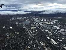
Sparks, Nevada
Sparks is a city in Washoe County, Nevada, United States. It was founded in 1904, incorporated on March 15, 1905, and is located just east of Reno. The 2019 U.S. Census Bureau American Community Survey population count was 105,006.[1] It is the fifth most populous city in Nevada. It is named after the late Nevada Governor John Sparks, a member of the Silver Party.
Sparks | |
|---|---|
 | |
| Nickname(s): The Rail City, City Of Promise | |
| Motto(s): "It's Happening Here!" | |
 Location in Washoe County | |
| Coordinates: 39°33′16″N 119°44′8″W | |
| Country | |
| State | |
| County | Washoe |
| Founded | 1904 |
| Incorporated | March 15, 1905 |
| Named for | John Sparks |
| Government | |
| • Type | Council–manager |
| • Mayor | Ron Smith (R) |
| Area | |
| • Total | 35.9 sq mi (93.0 km2) |
| • Land | 35.8 sq mi (92.6 km2) |
| • Water | 0.2 sq mi (0.4 km2) |
| Elevation | 4,413 ft (1,345 m) |
| Population (2018) | |
| • Total | 104,254 |
| • Estimate (2019)[1] | 105,006 |
| • Density | 2,900/sq mi (1,100/km2) |
| Time zone | UTC−8 (PST) |
| • Summer (DST) | UTC−7 (PDT) |
| ZIP codes | 89431 - 89437 - 89434 |
| Area code(s) | 775 |
| FIPS code | 32-68400 |
| GNIS feature ID | 0856391 |
| Interstates | |
| Major State Routes | |
| Waterways | Truckee River |
| Public transit | Regional Transportation Commission |
| Website | cityofsparks |
Nevada Historical Marker | |
| Reference no. | 88 |
Sparks is located within the Reno–Sparks metropolitan area.
History
The area that is now Sparks was first inhabited by the Washoe people. Euro-American settlement began in the early 1850s, and the population density remained very low until 1904 when the Southern Pacific Railroad built a switch yard and maintenance sheds there, after moving the division point from Wadsworth. In 1902, The Southern Pacific purchased a large tract of swamp-like land near its newly built railyard, and gave everyone clear deed to a 50' x 140' lot for the grand sum of $1. They also offered to pick up and move — free of charge — every house in Wadsworth and reassemble it in this new town.[2] As the population increased, a city was established, first called Harriman, after E.H. Harriman, president of the Southern Pacific, and then renamed Sparks, after John Sparks, then governor of Nevada.[3][4]
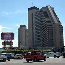
Sparks remained a small town until the 1950s, when economic growth in Reno triggered a housing boom north of the railroad in the area of Sparks. During the 1970s, the area south of the railroad started to fill up with warehouses and light industry. In 1984, the tower for the Nugget Casino Resort was finished, giving Sparks its first, and currently only, high-rise casino.[5] In 1996, the redevelopment effort of the B Street business district across from the Nugget that started in the early 1980s took a step forward with the opening of a multi-screen movie complex and the construction of a plaza area. This area, now known as Victorian Square, is a pedestrian-friendly district that hosts many open-air events.[3]
Under direction of the U.S. Environmental Protection Agency, a comprehensive dynamic water quality computer model, the DSSAM Model, was developed (Earth Metrics, 1987) to analyze impacts of a variety of land use and stormwater management decisions throughout the 3,120-square-mile (8,100 km2) Truckee River basin; this model was used to develop a set of surface runoff stormwater management measures for Sparks in the 1980s.[6]
Geography and climate
According to the U.S. Census Bureau, Sparks has a total area of 35.9 square miles (93.0 km2), of which 35.8 square miles (92.6 km2) is land and 0.15 square miles (0.4 km2), or 0.47%, is water.[7] Stormwater surface runoff from the city drains into the Truckee River, a sensitive waterway that empties into Pyramid Lake, which has no outlet and is the habitat of two endangered species.
Sparks has a semi-arid climate. Due to frequent low humidity, especially in the summer, daily temperature ranges are fairly wide. The average January temperatures are a maximum of 48.3 °F (9.1 °C) and a minimum of 23.5 °F (−4.7 °C). Average July temperatures are a maximum of 91.7 °F (33.2 °C) and a minimum of 53.6 °F (12.0 °C). There are an average of 52.3 days with highs of 90 °F (32 °C) and an average of 141.7 days with lows of 32 °F (0 °C). The record high temperature was 108 °F (42 °C) on July 11, 2002, and the record low temperature was −19 °F (−28 °C) on February 4, 2001.
Average annual precipitation in Sparks is 7.82 inches (199 mm). There are an average of 48 days with measurable precipitation. The wettest year was 1998 with 15.07 inches (383 mm) and the driest was 1990 with 4.65 inches (118 mm). The most precipitation in one month was 3.81 inches (97 mm) in December 2005, including the most precipitation in 24 hours (1.61 inches (41 mm)) on December 31.
Average snowfall per year is 7.0 inches (180 mm). The most snow in one year was 21.0 inches (530 mm) in 2008 and the most snow in one month was 19.6 inches (500 mm) in February 1990.[8]
Average monthly temperatures and precipitation
| Climate data for Sparks, Nevada | |||||||||||||
|---|---|---|---|---|---|---|---|---|---|---|---|---|---|
| Month | Jan | Feb | Mar | Apr | May | Jun | Jul | Aug | Sep | Oct | Nov | Dec | Year |
| Average high °F (°C) | 47 (8) |
53 (12) |
59 (15) |
65 (18) |
74 (23) |
84 (29) |
92 (33) |
90 (32) |
83 (28) |
71 (22) |
56 (13) |
47 (8) |
68 (20) |
| Average low °F (°C) | 23 (−5) |
26 (−3) |
31 (−1) |
35 (2) |
42 (6) |
48 (9) |
53 (12) |
51 (11) |
44 (7) |
35 (2) |
28 (−2) |
23 (−5) |
37 (3) |
| Average precipitation inches (mm) | 1.12 (28) |
0.97 (25) |
0.86 (22) |
0.60 (15) |
0.63 (16) |
0.47 (12) |
0.28 (7.1) |
0.32 (8.1) |
0.41 (10) |
0.63 (16) |
0.91 (23) |
1.13 (29) |
8.33 (211.2) |
| Source: [9] | |||||||||||||
Demographics
| Historical population | |||
|---|---|---|---|
| Census | Pop. | %± | |
| 1910 | 2,500 | — | |
| 1920 | 3,238 | 29.5% | |
| 1930 | 4,508 | 39.2% | |
| 1940 | 5,318 | 18.0% | |
| 1950 | 8,203 | 54.2% | |
| 1960 | 16,618 | 102.6% | |
| 1970 | 24,187 | 45.5% | |
| 1980 | 40,780 | 68.6% | |
| 1990 | 53,667 | 31.6% | |
| 2000 | 66,346 | 23.6% | |
| 2010 | 90,264 | 36.1% | |
| Est. 2019 | 105,006 | [1] | 16.3% |
| Source:[10] | |||
As of the American Community Survey of 2018, there were 104,246 people, 38,056 households residing in the city. The population density was 2,524.3 inhabitants per square mile (974.6/km2). The racial makeup of the city was 76.8% White, 2.5% African American, 1.5% Native American, 5.7% Asian, 0.5% Pacific Islander, and 5.0% from two or more races. Hispanic or Latino of any race were 29.3% of the population.
In 2018, the population of the city was spread out with 23.5% under the age of 18 and 15.3% who were 65 years of age or older. There were 50.3% females.[7]
In 2018 the estimated median income for a household in the city was $60,785 and 9.9% of the population were below the poverty line.[7]
Arts and culture
Cultural events include the Best in the West Nugget Rib Cook-off.[11]
Tourist attractions include the Great Basin Brewing Company, Nugget Casino Resort, and Scheels - The World's Largest All-Sports Store; featuring multiple indoor displays and exhibits, including an indoor ferris wheel, two giant aquariums one can walk through/under, and a gun library.[12]
Parks and recreation
The Nugget Event Center, is an outdoor concert amphitheater which seats 8,600 people right in the heart of downtown Sparks.
Sparks Marina Park was established on a naturally occurring aquifer in Sparks. Aquatic activities include windsurfing, sailing, swimming, scuba diving, fishing and boating. The surrounding park includes walking paths, a dog park, volleyball courts, playgrounds, picnic areas, showers, and a concession stand.[13]
The Mustang Ranch, described as "Nevada's most infamous brothel", has operated at various locations east of Sparks since 1967.[14]
Sparks is home to two golf courses, Wildcreek, and Red Hawk.
Education

Public education in Sparks is administered by the Washoe County School District. Schools located within the city district territory include:
High Schools
Middle Schools
- Sky Ranch Middle School
- Sparks Middle School
- Mendive Middle School
- Dilworth Middle School
- Desert Skies Middle School
Elementary Schools
- Robert Mitchell Elementary School
- Alice Maxwell Elementary School
- Florence Drake Elementary School
- Greenbrae Elementary School
- Lena Juniper Elementary School
- Bud Beasley Elementary School
- Van Gorder Elementary School
- Alyce Taylor Elementary School
- Spanish Springs Elementary School
- Excel Christian School – a private institution.
- Katherine Dunn Elementary School
- Miguel Sepulveda Elementary School
Sparks has two public libraries, one downtown adjacent, and another in Spanish Springs. Both are branches of the Washoe County Library System.[15]
Transportation

The Regional Transportation Commission of Washoe County (RTC) operates a city bus system that services the cities of Reno and Sparks.
Sparks is served by the nearby Reno–Tahoe International Airport.
Rail
The Union Pacific Railroad runs east–west through the center of Sparks. The Union Pacific has a significant rail yard south of I-80, just south and adjacent to the Nugget Hotel/Casino towers in downtown Sparks, and is a central part of the area's industrial park. Passenger rail service to the Sparks Amtrak Station ended in 2009, although service continues in neighboring Reno by the California Zephyr.
Roads
Interstate 80 runs east–west through Sparks. State Route 445 (Pyramid Way), El Rancho Drive, Sullivan Lane, Rock Boulevard, Sparks Boulevard, Vista Boulevard, and State Route 659 (McCarran Blvd) are the city's major north–south thoroughfares. Pyramid Way runs from Nugget Avenue in downtown Sparks to Pyramid Lake, about 35 miles north of the city, and has been designated a Nevada Scenic Byway.
Sparks is connected directly to south Reno by the Southeast Connector. It is a northerly extension of Veterans Parkway to the Sparks Boulevard at Greg Street. It serves as an expressway, with only 2 signaled intersections along its 5.5 mile stretch (one at Pembroke Drive and one at Mira Loma Drive), and constitutes a major arterial connection between Reno and Sparks. It provides an alternative route to existing, overcrowded routes such as the US-395/I-580 freeway, Rock Boulevard, and McCarran Boulevard. Construction began in late 2013, and was completed in July 2018.[16]
Sparks also is gearing up for the record of decision on a major, $1.1 billion (estimated) arterial road project, one that will turn a large portion of Pyramid Highway through nearby Spanish Springs into a controlled access, high speed arterial road that connects directly with the US 395 freeway via a complex interchange at the current Parr Boulevard connection. This will directly connect Spanish Springs, a major population center (parts of which are annexed with the city of Sparks), located in the valley just north of Sparks, with the existing Reno/Sparks freeway system which consists currently of Interstate 80 and US 395. This project will also offer more direct freeway system and inter-valley connections to and from Sun Valley, another major population center of the Reno/Sparks metropolitan statistical area. Sun Valley is located just north of Reno and just west of Spanish Springs, and is home to just over 20,000 residents as of 2020.
Notable people
- Mädchen Amick (b. 1970), actress on Twin Peaks and Witches of East End, born in Sparks[17]
- T.J. Bell (b. 1980), motorsport driver, grew up in Sparks[18]
- Scott Cousins (b. 1985), professional baseball player
- Brian Crane, syndicated cartoonist of Pickles
- Jacob Dalton (b. 1991), Olympic gymnast
- Jim Gibbons (b. 1944), former governor of Nevada
- Angelina Keeley (b. 1989), charity organizer, political activist, and runner-up of Survivor: David vs. Goliath
- David S. Loeb (1924–2003), businessman, co-founder of Countrywide and IndyMac
- Jena Malone (b. 1984), actress, The Hunger Games, Pride & Prejudice
- Jake McGee (b. 1986), professional baseball player
- Brian Retterer (b. 1972), NCAA champion swimmer
- Karl Rove (b. 1950), political activist, lobbyist, pundit, and Deputy White House Chief of Staff
- Dan Serafini (b. 1974), professional baseball player with Naranjeros de Hermosillo
- Josh Weston (1973–2012), adult film star
- Vernon White (b. 1971), mixed martial artist
Telecommunications
Sparks is served by AT&T and Spectrum.
References
- "Population and Housing Unit Estimates". Retrieved May 21, 2020.
- "The Great Race to Promontory". Union Pacific Railroad. Retrieved 17 September 2018.
- Toll, David W. (October 2002). The Complete Nevada Traveler: The Affectionate and Intimately Detailed Guidebook to the Most Interesting State in America. Reno: University of Nevada Press. pp. 68–69. ISBN 978-0-940936-12-6.
- Myrick, David F. (2007). Railroads of Nevada and Eastern California: The southern roads. Reno: University of Nevada Press. p. 868. ISBN 978-0-87417-194-5.
- Kling, Dwayne; Melton, Rollan (August 2010). The Rise of the Biggest Little City: An Encyclopedic History of Reno Gaming, 1931-1981. Reno: University of Nevada Press. p. 3. ISBN 978-0-87417-829-6.
- C.M.Hogan, Marc Papineau et al. Development of a dynamic water quality simulation model for the Truckee River, Earth Metrics Inc., Environmental Protection Agency Technology Series, Washington D.C. (1987)
- "U.S. Census Bureau QuickFacts Sparks city, Nevada". U.S. Census Bureau. Retrieved April 10, 2020.
- "Sparks, Nevada – Climate Summary". Wrcc.dri.edu. Retrieved 2013-01-16.
- "Monthly Averages for Sparks, NV (89431)". The Weather Channel. Retrieved October 18, 2012.
- Moffatt, Riley. Population History of Western U.S. Cities & Towns, 1850–1990. Lanham: Scarecrow, 1996, 158.
- Sonner, Scott (May 31, 2005). "Sparks sets lineup for annual cook-off". Las Vegas Review-Journal (AP). Retrieved 2009-09-07.
- Robison, Mark (7 April 2014). "Reno Rebirth: Beer, liquor makers grow in Nevada". Retrieved 7 April 2014.
- "Helms Lake at Sparks Marina Park". City of Sparks, Nevada.
- "Nevada's Most Infamous Brothel, Mustang Ranch, Back In Business". FOX News. August 5, 2007.
- "Nevada Public Libraries". PublicLibraries.com. Retrieved 14 June 2019.
- Higdon, Mike. "Southeast Connector opens next week, could save 14 minutes on your Reno-Sparks commute". Reno Gazette Journal. Retrieved 2019-08-27.
- "Happy Birthday To Westport's Mädchen Amick". Westport Daily Voice. December 12, 2015. Retrieved 2018-07-05.
- "Sparks' TJ Bell hits fast track at California Speedway". Reno Gazette-Journal. October 18, 2005. p. 51. Retrieved 2018-07-05 – via Newspapers.com.
Bell, a native of Sparks...
Further reading
- Earth Metrics Inc, C.M. Hogan, Marc Papineau, et al. Development of a dynamic water quality simulation model for the Truckee River, Environmental Protection Agency Technology Series, Washington D.C. (1987).
- Sparks Centennial History Book committee, History of Sparks: Centennial Edition (2004).
- Joyce M. Cox, Sparks (Images of America series, Arcadia Publishing, 2017).
External links
Municipalities and communities of Washoe County, Nevada, United States | ||
|---|---|---|
| Cities |  Washoe County map | |
| CDPs | ||
| Unincorporated communities |
| |
| Indian reservation | ||
| Indian colony | ||
| Ghost towns | ||