Winchester, Nevada
Winchester is an unincorporated town[1] and census-designated place (CDP) in Clark County, Nevada, United States that contains part of the Las Vegas Strip. It is one of a number of CDPs in the unincorporated urbanized area directly south of Las Vegas. The population was 27,978 at the 2010 census.[2] It is governed by the Clark County Commission with advice from the Winchester Town Advisory Board. "Winchester, NV" does not appear in postal addresses; the United States Postal Service has assigned "Las Vegas, NV" as the place name for the ZIP codes containing Winchester.
Winchester, Nevada | |
|---|---|
 Sahara Hotel Station of the monorail | |
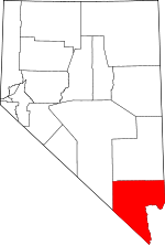
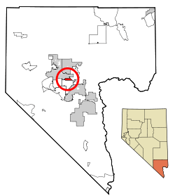 Location of Winchester in Clark County, Nevada | |
| Coordinates: 36°8′9″N 115°7′15″W | |
| Country | United States |
| State | Nevada |
| County | Clark |
| Founded | April 23, 1951 |
| Founded by | Clark County Commission |
| Area | |
| • Total | 4.3 sq mi (11.2 km2) |
| • Land | 4.3 sq mi (11.2 km2) |
| • Water | 0.0 sq mi (0.0 km2) |
| Elevation | 1,919 ft (585 m) |
| Population (2010) | |
| • Total | 27,978 |
| • Density | 6,500/sq mi (2,500/km2) |
| Time zone | UTC−8 (PST) |
| • Summer (DST) | UTC−7 (PDT) |
| ZIP code | 89169 |
| Area code(s) | 702 and 725 |
| FIPS code | 32-84600 |
| GNIS feature ID | 0845753 |
History
Founded as Paradise A on April 23, 1951, the town was renamed Winchester in 1953.[3]
Geography
Winchester sits in the east-central part of the Las Vegas Valley. To the north it borders Las Vegas, to the west and south is the CDP of Paradise, and to the east is Sunrise Manor.
Relative to streets, it is the area bordered by Sahara Avenue on the north, Boulder Highway on the east, Desert Inn Road on the south and the Union Pacific Railroad tracks on the west, with a few additional enclaves west of Interstate 15.[4]
According to the United States Census Bureau, the CDP has a total area of 4.3 square miles (11 km2), all land.
Demographics
| Historical population | |||
|---|---|---|---|
| Census | Pop. | %± | |
| 1970 | 13,981 | — | |
| 1980 | 19,728 | 41.1% | |
| 1990 | 23,365 | 18.4% | |
| 2000 | 26,958 | 15.4% | |
| 2010 | 27,978 | 3.8% | |
| source:[5] | |||
At the 2000 census there were 26,958 people, 11,986 households, and 6,052 families living in the CDP. The population density was 6,253.2 inhabitants per square mile (2,414.4/km2). There were 13,535 housing units at an average density of 3,139.6 inhabitants per square mile (1,212.2/km2). The racial makeup of the CDP was 71.83% White, 7.03% African American, 0.87% Native American, 5.36% Asian, 0.44% Pacific Islander, 9.66% from other races, and 4.81% from two or more races. Hispanic or Latino of any race were 29.01%.[6]
Of the 11,986 households 20.2% had children under the age of 18 living with them, 33.3% were married couples living together, 11.7% had a female householder with no husband present, and 49.5% were non-families. 38.7% of households were one person and 14.3% were one person aged 65 or older. The average household size was 2.24 and the average family size was 3.01.
The age distribution was 19.8% under the age of 18, 9.0% from 18 to 24, 29.2% from 25 to 44, 24.5% from 45 to 64, and 17.5% 65 or older. The median age was 40 years. For every 100 females, there were 106.4 males. For every 100 females age 18 and over, there were 105.7 males.
The median household income was $32,251 and the median family income was $39,451. Males had a median income of $27,886 versus $22,453 for females. The per capita income for the CDP was $20,615. About 11.4% of families and 14.0% of the population were below the poverty line, including 19.2% of those under age 18 and 8.5% of those age 65 or over.
References
- "Archived copy". Archived from the original on 2015-05-01. Retrieved 2015-04-12.CS1 maint: archived copy as title (link)
- "Profile of General Population and Housing Characteristics: 2010 Demographic Profile Data (DP-1): Winchester CDP, Nevada". U.S. Census Bureau. Retrieved March 13, 2012.
- "Paradise". Key to the City. Retrieved 2010-08-05.
- http://gisgate.co.clark.nv.us/gisplot_pdfs/gis/Winchester.pdf
- "CENSUS OF POPULATION AND HOUSING (1790-2000)". U.S. Census Bureau. Retrieved 2010-07-17.
- "U.S. Census website". United States Census Bureau. Retrieved 2008-01-31.
| Wikimedia Commons has media related to Winchester, Nevada. |
External links
Municipalities and communities of Clark County, Nevada, United States | ||
|---|---|---|
County seat: Las Vegas | ||
| Cities |
|  Clark County map |
| CDPs | ||
| Unincorporated communities | ||
| Ghost towns | ||
| Indian reservations |
| |
| Footnotes | ‡This populated place also has portions in an adjacent county or counties | |
| South end |  | |
|---|---|---|
| West side casinos | ||
| East side casinos | ||
| Former casinos | ||
| Shopping | ||
| Attractions | ||
| Transportation | ||
| Related | ||
Carson City (capital) | ||
| Topics |
|  |
| Society | ||
| Regions | ||
| Metro areas |
| |
| Counties | ||
| Cities and communities |
| |
| Former counties | ||