Fallon, Nevada
Fallon is a city in Churchill County in the U.S. state of Nevada. The population was 8,606 at time of the 2010 census.[4] Fallon is the county seat of Churchill County[5] and is located in the Lahontan Valley.
Fallon | |
|---|---|
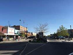 Maine Street in Fallon | |
| Nickname(s): The Oasis of Nevada[1] | |
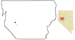 Location of Fallon and Churchill County, Nevada | |
 Fallon Location in the United States | |
| Coordinates: 39°28′22″N 118°46′44″W | |
| Country | United States |
| State | Nevada |
| County | Churchill |
| Founded | July 24, 1896 |
| Incorporated | 1908 |
| Named for | Michael Fallon |
| Government | |
| • Mayor | Ken Tedford (R)[2] |
| Area | |
| • Total | 3.65 sq mi (9.45 km2) |
| • Land | 3.63 sq mi (9.41 km2) |
| • Water | 0.02 sq mi (0.05 km2) |
| Elevation | 3,960 ft (1,207 m) |
| Population (2010) | |
| • Total | 8,606 |
| • Estimate (2018)[3] | 8,491 |
| • Density | 2,400/sq mi (910/km2) |
| Time zone | UTC−8 (PST) |
| • Summer (DST) | UTC−7 (PDT) |
| ZIP codes | 89406, 89407, 89496 |
| Area code(s) | 775 |
| FIPS code | 32-24100 |
| GNIS feature ID | 0840412 |
| Website | www |
History
The community was first populated during the gold rush, because multiple travelers stopped after crossing the Carson River.[6]
The town and post office were established on July 24, 1896 in a little shack belonging to Michael Fallon and Eliza Fallon,[7] who operated a ranch at the site.[8] Shortly afterwards, Jim Richards later operated a store near the post office.[9]
The town was officially incorporated in 1908.[9]
On June 16, 2019, downtown Fallon was listed in the National Register of Historic Places.[10]
Geography
Fallon is located in western Churchill County at the geographic coordinates 39°28′22″N 118°46′44″W (39.472792, -118.778826).[11] It is in the Lahontan Valley, a former lakebed into which flows the Carson River, which passes north of the city.
According to the United States Census Bureau, Fallon has a total area of 3.65 square miles (9.45 km2), of which 3.63 square miles (9.41 km2) is land and 0.02 square miles (0.05 km2), or 0.49%, is water.[4]
Demographics
As of the census[12] of 2000, there were 7,536 people, 3,004 households, and 1,877 families residing in the city. The population density was 2,474.1 people per square mile (954.0/km²). There were 3,336 housing units at an average density of 1,095.2 per square mile (422.3/km²). The racial makeup of the city was 76.5% White, 2.0% African American, 3.0% Native American, 4.7% Asian, 0.3% Pacific Islander, 0.3% from other races, and 3.3% from two or more races. Hispanic or Latino of any race were 9.9% of the population.
There were 3,004 households out of which 35.4% had children under the age of 18 living with them, 42.7% were married couples living together, 15.3% had a female householder with no husband present, and 37.5% were non-families. 30.7% of all households were made up of individuals and 11.4% had someone living alone who was 65 years of age or older. The average household size was 2.45 and the average family size was 3.06.
In the city, the population was spread out with 28.4% under the age of 18, 10.3% from 18 to 24, 29.7% from 25 to 44, 19.4% from 45 to 64, and 12.2% who were 65 years of age or older. The median age was 32 years. For every 100 females, there were 95.7 males. For every 100 females age 18 and over, there were 91.5 males.
The median income for a household in the city was $35,935, and the median income for a family was $41,433. Males had a median income of $35,356 versus $22,818 for females. The per capita income for the city was $16,919. About 9.5% of families and 12.6% of the population were below the poverty line, including 15.6% of those under age 18 and 10.3% of those age 65 or over.
Education
The city is served by the Churchill County School District. Churchill County High School is the main high school and also caters to students in rural areas outside the city. Western Nevada College has a campus in Fallon.
Fallon has a public library, the Churchill County Library.[13]
Climate
Fallon experiences a cold desert climate, with hot summers and cold winters. Due to Fallon's elevation and aridity, the diurnal temperature variation is quite substantial, especially in the summer months. Fallon's climate is quite dry, due to its location in the rain shadow of the Sierra Nevada. Summer days can be hot, but temperatures are cooler than in deserts such as the Mojave, Sonoran, and Chihuahuan deserts, due to Fallon's altitude and higher latitude north of the equator. In the winter, daytime temperatures are usually above freezing, but nights can be bitterly cold. Fallon can experience heavy fog in winter, known as pogonip.
Climate data below were accessed via the Western Regional Climate Center (WRCC) on 24 June 2020.[14]
| Climate data for Fallon, NV | |||||||||||||
|---|---|---|---|---|---|---|---|---|---|---|---|---|---|
| Month | Jan | Feb | Mar | Apr | May | Jun | Jul | Aug | Sep | Oct | Nov | Dec | Year |
| Record high °F (°C) | 71 (22) |
78 (26) |
84 (29) |
90 (32) |
102 (39) |
106 (41) |
108 (42) |
105 (41) |
100 (38) |
92 (33) |
81 (27) |
72 (22) |
108 (42) |
| Mean maximum °F (°C) | 60.1 (15.6) |
65.6 (18.7) |
73.6 (23.1) |
81.0 (27.2) |
88.9 (31.6) |
96.2 (35.7) |
100.2 (37.9) |
98.4 (36.9) |
93.0 (33.9) |
83.3 (28.5) |
70.6 (21.4) |
61.7 (16.5) |
100.6 (38.1) |
| Average high °F (°C) | 44.3 (6.8) |
51.3 (10.7) |
58.9 (14.9) |
65.9 (18.8) |
73.9 (23.3) |
83.1 (28.4) |
92.2 (33.4) |
90.1 (32.3) |
81.1 (27.3) |
69.2 (20.7) |
55.4 (13.0) |
45.4 (7.4) |
67.6 (19.8) |
| Average low °F (°C) | 18.1 (−7.7) |
23.2 (−4.9) |
27.8 (−2.3) |
33.9 (1.1) |
41.4 (5.2) |
47.9 (8.8) |
54.0 (12.2) |
51.4 (10.8) |
43.2 (6.2) |
33.8 (1.0) |
24.8 (−4.0) |
18.9 (−7.3) |
34.9 (1.6) |
| Mean minimum °F (°C) | 2.4 (−16.4) |
9.2 (−12.7) |
14.5 (−9.7) |
20.9 (−6.2) |
29.1 (−1.6) |
36.0 (2.2) |
43.8 (6.6) |
41.4 (5.2) |
31.5 (−0.3) |
31.5 (−0.3) |
11.2 (−11.6) |
4.2 (−15.4) |
−2.7 (−19.3) |
| Record low °F (°C) | −25 (−32) |
−27 (−33) |
1 (−17) |
13 (−11) |
20 (−7) |
27 (−3) |
35 (2) |
33 (1) |
21 (−6) |
6 (−14) |
−1 (−18) |
−21 (−29) |
−27 (−33) |
| Average precipitation inches (mm) | 0.54 (14) |
0.54 (14) |
0.46 (12) |
0.51 (13) |
0.60 (15) |
0.43 (11) |
0.16 (4.1) |
0.22 (5.6) |
0.28 (7.1) |
0.41 (10) |
0.38 (9.7) |
0.48 (12) |
5.01 (127.5) |
| Average snowfall inches (cm) | 1.8 (4.6) |
0.9 (2.3) |
0.8 (2.0) |
0.2 (0.51) |
0.1 (0.25) |
0 (0) |
0 (0) |
0 (0) |
0 (0) |
0.1 (0.25) |
0.5 (1.3) |
1.3 (3.3) |
5.7 (14.51) |
| Source: WRCC[15] | |||||||||||||
| Historical population | |||
|---|---|---|---|
| Census | Pop. | %± | |
| 1900 | 741 | — | |
| 1910 | 1,753 | 136.6% | |
| 1920 | 1,758 | 0.3% | |
| 1930 | 1,911 | 8.7% | |
| 1940 | 2,400 | 25.6% | |
| 1950 | 2,734 | 13.9% | |
| 1960 | 2,959 | 8.2% | |
| 1970 | 4,262 | 44.0% | |
| 1980 | 6,438 | 51.1% | |
| 1990 | 7,536 | 17.1% | |
| 2000 | 8,606 | 14.2% | |
| 2010 | 8,606 | 0.0% | |
| Est. 2018 | 8,491 | [3] | −1.3% |
| U.S. Decennial Census[16] | |||
Nuclear weapons testing
Los Alamos National Laboratory, in conjunction with the Department of Defense, conducted an underground nuclear test 28 miles (45 km) southeast of Fallon at 5 p.m. on October 26, 1963. Named Project Shoal, the 12.5-kiloton detonation was part of the Vela Uniform program. The device exploded at a depth of 1,205 feet (367 m) below ground surface.[17] The site is located in Gote Flat in the Sand Springs Range.
Access to the Project Shoal Area is unrestricted.[17] Access to the area is by Highway 50, Nevada Highway 839, then to an improved gravel road to the site.
In popular culture
- According to the Home Improvement episode "A Sew Sew Evening", Al was stationed in Fallon when he served in the Navy, which was a disappointment to him since he wanted to see the world. He used the native pronunciation of "Nevada", which is unusual for an outsider, especially someone in the Midwest.
- The Wizard, starring Fred Savage and Beau Bridges, was shot in and around Fallon as well.
- The Go-Getter, starring Zooey Deschanel and Jena Malone, mentions Fallon many times and even brings up Fallon's annual Heart 'O Gold Cantaloupe Festival. Malone's character lives in Fallon, and parts of the movie were filmed in and around Fallon.[18]
- Fallon is mentioned in The Stand by Stephen King.
Notable people
- John C. Carpenter, rancher, businessman, and politician, was born in Fallon.[19]
- Harvey Dahl, St. Louis Rams offensive lineman, was born in Fallon.[20]
- Martin Heinrich, U.S. Senator from New Mexico since 2013; was considered for nominee Hillary Clinton's running mate for the 2016 presidential election, born in Fallon but raised in Columbia, Missouri.
- Joshua Mauga, a Fallon native, plays for the Kansas City Chiefs.
- Georgie Sicking, cowboy poet, was formerly a rancher near Fallon.[21]
- Jim Walsh (1930–2018) built the Salmon Creek Railroad in Fallon.
- The Paiute-Shoshone Tribe of the Fallon Reservation and Colony is headquartered in Fallon.
Notes
- "About Fallon". Fallon Chamber of Commerce. Retrieved May 16, 2020.
- "Mayor's Office - City of Fallon". City of Fallon. Retrieved December 16, 2019.
- "Population and Housing Unit Estimates". Retrieved August 18, 2019.
- "Geographic Identifiers: 2010 Demographic Profile Data (G001): Fallon city, Nevada". U.S. Census Bureau, American actfinder. Archived from the original on February 12, 2020. Retrieved October 15, 2014.
- "Find a County". National Association of Counties. Archived from the original on 2011-05-31. Retrieved 2011-06-07.
- "Fallon | Loneliest Road in America, Nevada's Highway 50". Retrieved 2020-05-28.
- Carlson, Helen S. (1985). Nevada place names : a geographical dictionary. Reno: University of Nevada Press. p. 111. ISBN 978-0-87417-094-8.
- Federal Writers' Project (1941). Origin of Place Names: Nevada (PDF). W.P.A. p. 11.
- "All About Fallon!". Fallon Chamber of Commerce. Retrieved 2020-05-28.
- Resources, Department of Conservation and Natural. "Downtown Fallon listed in the National Register of Historic Places". www.nevadaappeal.com. Retrieved 2020-05-29.
- "US Gazetteer files: 2010, 2000, and 1990". United States Census Bureau. 2011-02-12. Retrieved 2011-04-23.
- "U.S. Census website". United States Census Bureau. Retrieved 2008-01-31.
- "Nevada Public Libraries". PublicLibraries.com. Retrieved 14 June 2019.
- "FALLON EXP STN, NEVADA - Climate Summary". wrcc.dri.edu. Retrieved 2020-06-24.
- https://wrcc.dri.edu/cgi-bin/cliMAIN.pl?nv2780
- "Census of Population and Housing". Census.gov. Retrieved June 4, 2015.
- "Remediation Project Shoal Area, Nevada Division of Environmental Protection". Archived from the original on 2009-03-23.
- imdb.com
- 'Former Assemblyman John Carpenter Dies,' Elko Daily Free Press, Marianne Kobak McKown, November 21, 2016
- "St. Louis Lineman Called for Holding Yells, "That's Not Fucking Holding!" into Ref's Open Mic, and then It Gets Weird".
- ""The Last of the Old-Time Cowboys": Interview with Georgie Sicking, Fallon, Nevada, August 22, 1992". americanfolk.com. Retrieved January 30, 2014.
References
- Steinmaus, C., M. Lu, R.L. Todd, A.H. Smith. Probability estimates for the unique childhood leukemia cluster in Fallon, Nevada, and risks near other U.S. military aviation facilities. Environmental Health Perspectives. 112(6): 766–771. May 2004.
External links
| Wikimedia Commons has media related to Fallon, Nevada. |
- City of Fallon official website
- Fallon Chamber of Commerce
- Fallon business
- Grimes Point Trail (Bureau of Land Management), with pictures of the carvings
Municipalities and communities of Churchill County, Nevada, United States | ||
|---|---|---|
| City |  Churchill County map | |
| CDP | ||
| Unincorporated communities |
| |
| Indian reservations | ||
| Ghost towns | ||
| Authority control |
|
|---|