Nevada State Route 28
State Route 28 (SR 28) is a 16.3-mile (26.2 km) state highway in Douglas County, Carson City, and Washoe County in western Nevada, United States, that runs along the northeastern shore of Lake Tahoe. SR 28 connects U.S. Route 50 in Nevada (US 50) in Douglas County with California State Route 28 at Crystal Bay. SR 28 has been part of the National Scenic Byway system since September 1996 and the state scenic byway system since June 1994.[2][3]
| ||||
|---|---|---|---|---|
 | ||||
| Route information | ||||
| Maintained by NDOT | ||||
| Length | 16.272 mi[1] (26.187 km) | |||
| Existed | 1948–present | |||
| Tourist routes | North Shore Road[3] | |||
| Major junctions | ||||
| South end | ||||
| North end | ||||
| Location | ||||
| Counties | Douglas, Carson City, Washoe | |||
| Highway system | ||||
| ||||

Route description

SR 28 begins at Spooner Junction, a T intersection with US 50 (also known as the Lincoln Highway) and SR 28 on the border between the Humboldt–Toiyabe National Forest and the Lake Tahoe – Nevada State Park in northwestern Douglas County, just south of Spooner Lake. (US 50 heads west toward Glenbrook, Zephyr Cove, and eventually Sacramento, California. US 50 heads west toward a junction with US 395, Carson City, and Fallon.)
From its southern terminus SR 28 heads northwest, initially along the border between the national forest and the state park. After about 1 mile (1.6 km) the highway leaves Douglas County and enters Carson City (independent city) and fully enters the state park. Shortly thereafter the highway crosses over North Canyon Creek, and about 1 mile (1.6 km) after entering the state park, the highway leaves the park and enters the Humboldt–Toiyabe National Forest. Assuming a northerly course, SR 28 continues through the national forest and, after about another 3 miles (4.8 km), the highway leave Carson City and enters Washoe County.
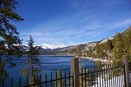
Just over 1 mile (1.6 km) after entering Washoe County, SR 28 begins a segment (of approximately 4 miles [6.4 km]) which runs along the east shore of Lake Tahoe. About 1⁄2 mile (0.80 km) along this segment, SR 28 leaves the national forest to renter the state park. The route then passes just east of the Sand Harbor area of the state park, site of the annual Lake Tahoe Shakespeare Festival.[4] North of Sand Harbor, SR 28 is also known as Tahoe Boulevard. Just over 3 miles (4.8 km) after reentering the state park, the route finally leaves it, briefly passes through another short section of the national forest, and enters the census-designated place of Incline Village.
Upon entering Incline Village, the route leaves the Lake Tahoe shoreline and connects with the eastern end of Lakeshore Boulevard at a T intersection (which heads west to reconnect with SR 28) and then turns to a westerly heading through the community. About 3.5 miles (5.6 km) after entering the community, near the west side of town, SR 28 connects with the southern end of Nevada State Route 431 (SR 431)at a roundabout. (SR 431, also known as Mount Rose Highway, heads northeasterly toward a junction with US 395, Reno, Nevada|Reno]], and Virginia City.) About 1⁄2 mile (0.80 km) later SR 28 reconnects with Lakeshore. At that intersection, which also includes Pinion Drive (heading north), Tahoe Boulevard ends and SR 28 begins running along Lakeshore Boulevard. Continuing west, the highway resumes running along the shore of Lake Tahoe before it leaves Incline Village and turns south toward census-designated place of Crystal Bay.
.jpg)
As SR 28 heads south, it runs less than 1 mile (1.6 km) from and roughly parallel to the California state line. In southern Crystal Bay, the turns west and promptly reaches its western terminus at the California state line and the eastern end of California State Route 28 at an intersection with Stateline Road. (California State Route 28 continues west through the census-designated place and border community of Kings Beach (including the community of Brockway) and on to Tahoe Vista and Tahoe City.[5]
Around 11,300 cars use SR 28 on average each day.[6] SR 28 is not part of the National Highway System.[7]
History
The road that became SR 28 (which has been used for flumes in the timber industry since 1880)[8] it was paved around 1932.[9] The route first appeared in 1948,[10] with the same general alignment as it has today.[11] The highway gained fame for many years as the location of the Ponderosa Ranch, filming location of the television series Bonanza that is located on the east end of Incline Village.[12] On June 7, 1994, the Nevada Department of Transportation (NDOT) designated SR 28 as a scenic byway, named North Shore Road.[3] Later in September 1996, SR 28 and part of US 50 was designated as Lake Tahoe - Eastshore Drive, a National Scenic Byway.[2]
Major intersections
- Note: Mileposts in Nevada reset at county lines; the start and end mileposts for each county are given in the county column.
| County | Location[5] | mi [1] | km | Destinations | Notes |
|---|---|---|---|---|---|
| Douglas 0.00–1.23 | | 0.00 | 0.00 | Southern terminus | |
| City of Carson City 0.00–3.95 | No major juctions | ||||
| Washoe 0.00–11.09 | Incline Village | 4.98 | 8.01 | Lakeshore Boulevard – SR 28 | |
| 8.08 | 13.00 | Roundabout | |||
| Crystal Bay | 11.09 | 17.85 | California state line | Northern terminus | |
| Continuation into California | |||||
| 1.000 mi = 1.609 km; 1.000 km = 0.621 mi | |||||
See also
- List of state highways in Nevada
References
- Nevada Department of Transportation (January 2017). "State Maintained Highways of Nevada: Descriptions and Maps". Retrieved May 7, 2017.
- "Lake Tahoe – Eastshore Drive". byways.org. Federal Highway Administration. Archived from the original on August 19, 2013. Retrieved May 3, 2020 – via Wayback Machine.
- "Nevada's Scenic Byways". nevadadot.com. Nevada Department of Transportation. Archived from the original on August 21, 2013. Retrieved May 3, 2020 – via Wayback Machine.
- "Lake Tahoe Shakespeare Festival: Extraordinary Entertainment in an Exceptional Setting". laketahoeshakspeare.com. Incline Village, Nevada: Lake Tahoe Shakespeare Festival. Retrieved May 3, 2020.
- Google (July 30, 2013). "Nevada State Route 28" (Map). Google Maps. Google. Retrieved July 30, 2013.
- "2012 Annual Traffic Report" (PDF). Nevada Department of Transportation. Archived from the original (PDF) on March 5, 2014. Retrieved July 30, 2013.
- National Highway System: Nevada (PDF) (Map). Federal Highway Administration. March 2013. Retrieved July 30, 2013.
- "The Great Incline of the Sierra Nevada". State of Nevada, State Historic Preservation Office. Archived from the original on July 31, 2013. Retrieved July 30, 2013.
- 1932 Map of Nevada (Map). Cartography by Nevada Department of Highways. Nevada Department of Highways. 1932. Archived from the original on September 10, 2006. Retrieved July 31, 2013.
- 1948 Map of Nevada (PDF) (Map). Cartography by Nevada Department of Highways. Nevada Department of Highways. 1948. Archived from the original (PDF) on May 29, 2013. Retrieved July 29, 2013.
- Official Nevada State Map (PDF) (Map). Cartography by Nevada Department of Transportation. Nevada Department of Transportation. Lake Tahoe inset. Archived from the original (PDF) on May 12, 2013. Retrieved 2013-07-29.
- Google (July 29, 2013). "Ponderosa Ranch" (Map). Google Maps. Google. Retrieved July 29, 2013.