Placerville, California
Placerville (/ˈplæsərvɪl/, PLASS-ər-vil; formerly Old Dry Diggings, Dry Diggings, and Hangtown[9]) is the county seat of El Dorado County, California. The population was 10,389 at the 2010 census, up from 9,610 at the 2000 census. It is part of the Sacramento–Arden-Arcade–Roseville Metropolitan Statistical Area.
Placerville, California | |
|---|---|
City | |
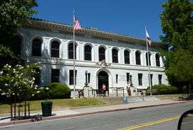 El Dorado County Courthouse | |
 Seal | |
| Nickname(s): Hangtown[1] | |
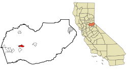 Location of Placerville in California. | |
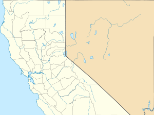 Placerville Location of Placerville in Northern California  Placerville Location of Placerville in California  Placerville Location of Placerville in the United States | |
| Coordinates: 38°43′47″N 120°47′55″W[2] | |
| Country | |
| State | |
| County | |
| Incorporated | May 13, 1854[3] |
| Government | |
| • Mayor | John Clerici[4] |
| Area | |
| • Total | 5.81 sq mi (15.05 km2) |
| • Land | 5.81 sq mi (15.05 km2) |
| • Water | 0.00 sq mi (0.00 km2) 0.01% |
| Elevation | 1,867 ft (569 m) |
| Population (2010) | |
| • Total | 10,389 |
| • Estimate (2019)[6] | 11,175 |
| • Density | 1,837.75/sq mi (709.57/km2) |
| Time zone | UTC-8 (PST) |
| • Summer (DST) | UTC-7 (PDT) |
| ZIP code | 95667[7] |
| Area code | 530 |
| FIPS code | 06-57540 |
| GNIS feature IDs | 277577, 2411433 |
| Website | www |
| Reference no. | 701[8] |
History
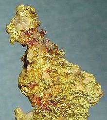
After the discovery of gold at Sutter's Mill in nearby Coloma, California, by James W. Marshall in 1848 sparked the California Gold Rush, the small town now known as Placerville was known as Dry Diggin's after the manner in which the miners moved cartloads of dry soil to run water to separate the gold from the soil. Later in 1849, the town earned its most common historical name, "Hangtown", because of the numerous hangings that had occurred there.[10] According to the museum guide at the Fountain & Tallman Museum, there were only three hangings that occurred after three men on horseback came into town with guns ablaze. The name stuck after that. By about 1850, the temperance league and a few local churches had begun to request that a more friendly name be bestowed upon the town. The name was not changed until 1854 when the City of Placerville was incorporated. At its incorporation, Placerville was the third largest town in California. In 1857 the county seat was then moved from Coloma to Placerville, where it remains today.
Placerville was a central hub for the Mother Lode region's mining operations.[11] The town had many services, including transportation (of people and goods), lodging, banking, and had a market and general store. The history of hard-rock mining is evidenced by an open and accessible Gold Bug Park & Mine, now a museum with tours and books.[12]
The Southern Pacific Railroad once had a branch line that extended from Sacramento to Placerville. The track was abandoned in the 1980s. The Camino, Placerville and Lake Tahoe Railroad (now abandoned) also operated an 8-mile (13 km) shortline that operated between Camino, California, and Placerville until June 17, 1986. As of March 29, 2007, 52 miles (84 km) of the right-of-way have been purchased by the city of Folsom, and 18 miles (29 km) of track have been restored. Plans are in motion for a tourist train along the route by 2015.[8]
The town's first post office opened in 1850.[9]
Placerville is now registered as California Historical Landmark #701.[8]
National Register of Historic Places gallery
Placerville has several buildings listed on the National Register of Historic Places; several are noted below.
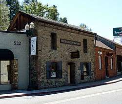 Fountain-Tallman Soda Works (now the Fountain & Tallman Museum)
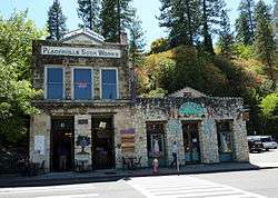
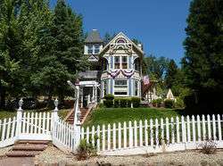 Combellack-Blair House
Geography
Placerville is located in the Sierra Nevada foothills where U.S. Route 50 crosses State Route 49. It is the location of three traffic signals along U.S. Route 50, which is otherwise a freeway.
Downtown Placerville is about 1,867 feet (569 m) above sea level,[1] while unincorporated areas of the city range from 1,800 feet (550 m) to nearly 4,000 feet (1,200 m).
According to the United States Census Bureau, the city has a total area of 5.8 square miles (15 km2), over 99% of it land.
Climate
Placerville has cool, frequently wet winters and hot, dry summers, creating a typically Californian Mediterranean climate (Köppen Csa). Average January temperatures are a maximum of 53.4 °F (11.9 °C) and a minimum of 32.5 °F (0.3 °C). Average July temperatures are a maximum of 92.7 °F (33.7 °C) and a minimum of 57.2 °F (14.0 °C). Annually, there are an average of 65.7 days with highs of 90 °F (32 °C) or higher and 61.3 mornings with lows of 32 °F (0 °C) or lower. The record high temperature was 114 °F (46 °C) on July 4, 1911. The record low temperature was 8 °F (−13.3 °C) on December 9, 1972.
Average annual rainfall in Placerville is 38.11 inches (968.0 mm). There are an average of 66 days with measurable rain. The wettest calendar year was 1983 with 74.55 inches (1,893.6 mm) and the driest 1976 with 11.85 inches (301 mm). The most rainfall in one month was 23.29 inches (591.6 mm) in December 1955. The most rainfall in 24 hours was 6.22 inches (158 mm) on February 14, 2000.[13] Although snowfall is rare in Placerville, heavy amounts often fall in the mountains east of the city.
| Climate data for Placerville, California (1915-2005) | |||||||||||||
|---|---|---|---|---|---|---|---|---|---|---|---|---|---|
| Month | Jan | Feb | Mar | Apr | May | Jun | Jul | Aug | Sep | Oct | Nov | Dec | Year |
| Record high °F (°C) | 75 (24) |
78 (26) |
87 (31) |
92 (33) |
104 (40) |
109 (43) |
110 (43) |
109 (43) |
108 (42) |
100 (38) |
83 (28) |
76 (24) |
110 (43) |
| Average high °F (°C) | 53.3 (11.8) |
56.9 (13.8) |
60.2 (15.7) |
66.3 (19.1) |
74.5 (23.6) |
83.7 (28.7) |
92.4 (33.6) |
91.3 (32.9) |
85.5 (29.7) |
74.8 (23.8) |
61.1 (16.2) |
53.9 (12.2) |
71.2 (21.8) |
| Daily mean °F (°C) | 42.8 (6.0) |
45.8 (7.7) |
48.8 (9.3) |
53.3 (11.8) |
60.3 (15.7) |
67.7 (19.8) |
74.8 (23.8) |
73.6 (23.1) |
68.5 (20.3) |
59.8 (15.4) |
49.0 (9.4) |
43.4 (6.3) |
57.3 (14.1) |
| Average low °F (°C) | 32.4 (0.2) |
34.7 (1.5) |
37.4 (3.0) |
40.3 (4.6) |
46.0 (7.8) |
51.6 (10.9) |
56.8 (13.8) |
55.9 (13.3) |
51.5 (10.8) |
44.7 (7.1) |
37.1 (2.8) |
32.9 (0.5) |
43.4 (6.4) |
| Record low °F (°C) | 9 (−13) |
15 (−9) |
19 (−7) |
24 (−4) |
29 (−2) |
31 (−1) |
38 (3) |
37 (3) |
33 (1) |
23 (−5) |
21 (−6) |
8 (−13) |
8 (−13) |
| Average rainfall inches (mm) | 7.05 (179) |
6.70 (170) |
5.85 (149) |
3.09 (78) |
1.52 (39) |
0.46 (12) |
0.08 (2.0) |
0.09 (2.3) |
0.56 (14) |
2.12 (54) |
4.52 (115) |
6.52 (166) |
38.56 (980.3) |
| Average snowfall inches (cm) | 1.2 (3.0) |
0.4 (1.0) |
0.4 (1.0) |
0.3 (0.76) |
0 (0) |
0 (0) |
0 (0) |
0 (0) |
0 (0) |
0 (0) |
0 (0) |
0.4 (1.0) |
2.7 (6.76) |
| Average rainy days | 10 | 10 | 10 | 7 | 4 | 2 | 0 | 1 | 1 | 4 | 7 | 10 | 66 |
| Source: http://www.wrcc.dri.edu/cgi-bin/cliMAIN.pl?caplac+nca | |||||||||||||
Demographics
| Historical population | |||
|---|---|---|---|
| Census | Pop. | %± | |
| 1860 | 2,466 | — | |
| 1870 | 1,562 | −36.7% | |
| 1880 | 1,951 | 24.9% | |
| 1890 | 1,690 | −13.4% | |
| 1900 | 1,748 | 3.4% | |
| 1910 | 1,914 | 9.5% | |
| 1920 | 1,650 | −13.8% | |
| 1930 | 2,322 | 40.7% | |
| 1940 | 3,064 | 32.0% | |
| 1950 | 3,749 | 22.4% | |
| 1960 | 4,439 | 18.4% | |
| 1970 | 5,416 | 22.0% | |
| 1980 | 6,739 | 24.4% | |
| 1990 | 8,355 | 24.0% | |
| 2000 | 9,610 | 15.0% | |
| 2010 | 10,389 | 8.1% | |
| Est. 2019 | 11,175 | [6] | 7.6% |
| U.S. Decennial Census[14] | |||
The 2010 United States Census[15] reported that Placerville had a population of 10,389. The population density was 1,787.3 people per square mile (690.1/km²). The racial makeup of Placerville was 8,716 (83.9%) White, 80 (0.8%) African American, 162 (1.6%) Native American, 98 (0.9%) Asian, 13 (0.1%) Pacific Islander, 867 (8.3%) from other races, and 453 (4.4%) from two or more races. Hispanic or Latino of any race were 1,863 persons (17.9%).
The Census reported that 9,788 people (94.2% of the population) lived in households, 131 (1.3%) lived in non-institutionalized group quarters, and 470 (4.5%) were institutionalized.
There were 4,129 households, out of which 1,254 (30.4%) had children under the age of 18 living in them, 1,607 (38.9%) were opposite-sex married couples living together, 604 (14.6%) had a female householder with no husband present, 250 (6.1%) had a male householder with no wife present. There were 327 (7.9%) unmarried opposite-sex partnerships, and 31 (0.8%) same-sex married couples or partnerships. 1,306 households (31.6%) were made up of individuals and 599 (14.5%) had someone living alone who was 65 years of age or older. The average household size was 2.37. There were 2,461 families (59.6% of all households); the average family size was 2.97.
The population was spread out with 2,277 people (21.9%) under the age of 18, 972 people (9.4%) aged 18 to 24, 2,468 people (23.8%) aged 25 to 44, 2,831 people (27.2%) aged 45 to 64, and 1,841 people (17.7%) who were 65 years of age or older. The median age was 40.4 years. For every 100 females, there were 90.3 males. For every 100 females age 18 and over, there were 86.9 males.
There were 4,541 housing units at an average density of 781.2 per square mile (301.6/km²), of which 4,129 were occupied, of which 2,160 (52.3%) were owner-occupied, and 1,969 (47.7%) were occupied by renters. The homeowner vacancy rate was 3.5%; the rental vacancy rate was 7.8%. 5,023 people (48.3% of the population) lived in owner-occupied housing units and 4,765 people (45.9%) lived in rental housing units.
Government
In the California State Legislature, Placerville is in the 1st Senate District, represented by Republican Brian Dahle,[16] and the 5th Assembly District, represented by Republican Frank Bigelow.[17]
In the United States House of Representatives, Placerville is in California's 4th congressional district, represented by Republican Tom McClintock.[18]
Economy
The region east of Placerville, popularly known as Apple Hill and Pleasant Valley, is becoming a center for wine production. The wine region is officially designated as the El Dorado AVA. The largest wineries in the area are Boeger, Lava Cap and Madrona, but most of the 30 plus wineries surrounding Placerville are family owned and smaller in wine grape and wine production. The region is "renown[ed] for making vibrantly flavorful, distinctly delicious wines, grown in the dramatic elevations of the Sierra Nevada."[19] The area is increasingly a center for sophisticated production of Rhone style wines, noted by El Dorado County having a local chapter of the Rhone Rangers winemaker association.
Formerly known as Anderson Field, the arena and main grandstand that is now known as Placerville Speedway was originally built by the El Dorado County Fair during the winter months of 1956. Constructing a clay racing surface around the perimeter of the football field, Warren Jewitt and Bruno Romani created what was originally known as "Hangtown Speedway". Auto racing took place here for the first time on June 18, 1965.
Since 1965, Placerville Speedway has hosted several racing divisions. The track was cut out of a hillside, giving it higher banking, and covered with a dark red clay racing surface.[20]
Placerville is home to the Mountain Democrat newspaper and Marshall Medical Center.
Transportation
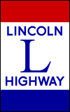
Placerville is served by two major highways. California State Route 49 runs north and south, connecting the city with the other major communities in the Sierra Nevada foothills. U.S. Route 50 heads west to Sacramento and east to South Lake Tahoe. This portion of U.S. Route 50 is a part of the Lincoln Highway.[21]
El Dorado Transit runs public bus service, both local routes connecting Placerville to other populated areas on the western slope and weekday commuter service to/from Sacramento. Amtrak's thruway bus service stops in Placerville along its route connecting Sacramento and South Lake Tahoe.
Placerville is served by the Placerville Airport.[22] A Good Neighbor Airport, it has a 4,200-foot-long (1,300 m) runway, but is not currently served by any commercial air transport.
Culture
Placerville has many old buildings from the Gold Rush days.[23] A walk down Main Street also reveals many historical markers, signifying spots of certain events or persons of importance during this period. Placerville was also on the line of the Pony Express, a short-lived mail carrier service that connected California to the Midwest and East (basically from Sacramento to St. Joseph, Missouri).
Historically, Placerville was often referred to by the name "Hangtown," because of the frequent hangings that occurred in the lawless area. Those traveling in the area can still see the old hangman's platform that was used for public hangings[24] along with a commemorative mannequin ("Willie") hanging from a noose above the Old Hangman's Tree. The dummy enjoyed a brief hiatus when town officials attempted to freshen up the town's image before returning due to popular demand. In 2015 the dummy was stolen.[25] It has since been replaced.
Placerville is home to the legendary dish known as the "Hangtown Fry" which includes eggs, bacon, and oysters. There are multiple legends regarding the origin, but all stories agree that Placerville is the place of origin.
The Southern Pacific Transportation Company branch line was purchased from the Union Pacific in 1996 for $14 million by the Joint Powers Authority consisting of Sacramento County, Folsom, and El Dorado County. The line is being restored to run historic excursion trains from Folsom to Placerville on a total of 35 miles (56 km) of track.
Placerville is the home of United Ancient Order of Druids of California Grove No. 1, which was reinstated in 2017–18, along with several other historical fraternal societies. Main Street Placerville features a large stone column holding a glass and metal "torch" known as "The Druid Monument", commemorating the Order's inception there 1860.[26] [27] The City of Placerville is currently attempting to repave the roundabout containing the monument, possibly removing it permanently in the process—a proposal that has divided the community.[28]
Notable people
Over the years many notable and influential people had shops in Placerville, mostly along the now historic Main Street.[29]
Historical persons:
- Horace Bell - lawyer, journalist, historian
- T.J. Caystile - newspaperman
- Oliver Gagliani - photographer
- Henry Hooker - cattle baron
- Mark Hopkins, Jr. - railroad financier
- Edwin Markham - poet
- Ziba Peterson - hanging sheriff of 1849
- John Augustus Raffetto - hotelier and banker
- Levi Strauss - clothing maker
- John Studebaker - auto maker
- Jesse Yarnell — newspaperman
Contemporary notable persons:
- Amy Bruni - Ghost Hunters Investigator
- Dan Crary - bluegrass flat-picking guitarist, retired PhD professor of communications at Cal State Fullerton.
- Toby Hall - baseball player
- Thomas Kinkade - painter
- Larry LaLonde - Primus guitarist
- Bevo LeBourveau - baseball player, later a policeman in Placerville
- Alexander Howison Murray Jr. AKA "Sandy Murray," mayor
- Nello Olivo - winemaker
- Michael Raffetto — radio star
- Spider Sabich — ski racer from Kyburz - buried in Placerville
- Ralph Taeger - actor; operated Taeger's Firewood Company in Placerville
- Jerome R. Waldie - U.S. Representative from California
Gallery
 Town Hall
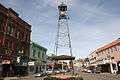 Placerville bell
See also
References
Notes
- "Placerville". Geographic Names Information System. United States Geological Survey.
- "US Gazetteer files: 2010, 2000, and 1990". United States Census Bureau. February 12, 2011. Retrieved April 23, 2011.
- "California Cities by Incorporation Date". California Association of Local Agency Formation Commissions. Archived from the original (Word) on November 3, 2014. Retrieved April 5, 2013.
- "Mayor Wilkins". City of Placerville, CA. Retrieved February 26, 2015.
- "2016 U.S. Gazetteer Files". United States Census Bureau. Retrieved June 28, 2017.
- "Population and Housing Unit Estimates". Retrieved May 21, 2020.
- "ZIP Code(tm) Lookup". United States Postal Service. Retrieved November 23, 2014.
- "Placerville". Office of Historic Preservation, California State Parks. Retrieved October 7, 2012.
- Durham, David L. (1998). California's Geographic Names: A Gazetteer of Historic and Modern Names of the State. Clovis, Calif.: Word Dancer Press. p. 539. ISBN 1-884995-14-4.
- "El Dorado County Visitor's Guide". Archived from the original on May 13, 2008.
- "El Dorado County Visitors Authority". Archived from the original on April 26, 2007. Retrieved May 1, 2007.
- Hangtown's Gold Bug Park & Mine.
- "PLACERVILLE, CALIFORNIA - Climate Summary".
- "Census of Population and Housing". Census.gov. Retrieved June 4, 2015.
- "2010 Census Interactive Population Search: CA - Placerville city". U.S. Census Bureau. Archived from the original on July 15, 2014. Retrieved July 12, 2014.
- "Senators". State of California. Retrieved April 5, 2013.
- "Members Assembly". State of California. Retrieved April 5, 2013.
- "California's 4th Congressional District - Representatives & District Map". Civic Impulse, LLC. Retrieved March 2, 2013.
- El Dorado Winery Association
- "PLACERVILLE.SPEEDWAY | History".
- A Lincoln Highway route marker is embedded in the front wall of a building at 564 Main Street.
- "Archived copy". Archived from the original on March 30, 2010. Retrieved April 22, 2010.CS1 maint: archived copy as title (link)
- Historical buildings and monuments in El Dorado County
- El Dorado, County Visitor's Guide
- https://www.mtdemocrat.com/news/hangman-willie-slips-from-his-noose-again/
- "Druids of California".
- "Druid Monument in Placerville".
- https://www.mtdemocrat.com/news/roundabout-opponents-now-take-aim-at-clay-street-bridge-project/
- Historic Main Street, Placerville.
External links
| Wikimedia Commons has media related to Placerville, California. |
- Official website

- The Mountain Democrat (local newspaper)
- Placerville Downtown Association
| Authority control |
|
|---|