Madhubani, India
Madhubani is a town municipality and headquarter of Madhubani district. Madhubani is situated in the Indian state of Bihar. It comes under Darbhanga Division. It lies 26 km northeast of Darbhanga town and was part of the erstwhile 'Bettiah Raj'. The Madhuban Raj in Madhubani was created as a consequence.[1] The word "Madhuban" means "forest of honey" from which Madhubani is derived, but sometimes it is also known as "madhu"+"vaani" meaning "sweet" "voice/language".[2]
Madhubani | |
|---|---|
Town | |
 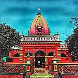    Clockwise from top: Madhubani City skyline from Madhubani Railway Station,Kali Mandir, Police Line mandir,Hanuman Mandir,School Student. | |
 Madhubani Location in Bihar, India  Madhubani Madhubani (India) | |
| Coordinates: 26.37°N 86.08°E | |
| Country | |
| State | Bihar |
| Region | Mithila |
| District | Madhubani |
| Elevation | 56 m (184 ft) |
| Population (2011) | |
| • Total | 75,736 |
| Languages | |
| • Official | Maithili, Hindi, English |
| Time zone | UTC+5:30 (IST) |
| PIN | |
| Telephone code | 06276 |
| ISO 3166 code | IN-BR |
| Vehicle registration | BR-32 |
| Sex ratio | 1000/942 ♂/♀ |
| Lok Sabha constituency | Madhubani |
| Vidhan Sabha constituency | Madhubani, Bisfi |
| Website | madhubani |
Area
- Madhubani occupies a total of 3501 km2.
- Main Rivers are Kamla, Kareh, Balan, Bhutahi Balan, Gehuan, Supen, Trishula, Jeevachh, Koshi and Adhwara Group.
- High Flood Level is 54.017 m.
- Whole District is under Earthquake Zone 5.
- Total Cropped Area - 218381 Hect.
- Barren /Uncultivable Land - 1456.5 Hect
- Land under Non-agricultural use - 51273.24 Hect
- Cultivable Barren Land - 333.32 Hect
- Permanent Pasture - 1372.71 Hect
- Miscellaneous Trees - 8835.90 Hect
- Cultivable Land - 232724 Hect
- Cropping Intensity - 134.23%[3]
Geography
Madhubani Town is located at 26.37°N 86.08°E.[4] It has an average elevation of 56 metres (183 feet).
Demographics
As of 2011 India census,[5] Madhubani Town had a population of 166,285. Males constitute 53% of the population and females 47%. Madhubani Town has an average literacy rate of 71.06 %, just above the national average of 62.39 %: male literacy is 78.81 %, and female literacy is 53%. In Madhubani Town, 16% of the population is under 6 years of age.
Trade
Laukaha is a nearby town close to the border of Nepalese town of Thadi. Laukaha in India and Thadi in Nepal are a part of one of the agreed route for Mutual Trade between India and Nepal and import and export to Nepal happen via Laukaha.[6] Government of Nepal has set up a dedicated customs office in the town.[7] and Government of India has set up a Land Customs Station with a Superintendent level officer.[8]
Notable people
- Vidyapati
- Maṇḍana_Miśra
- Udit Narayan
- Aditya Narayan
- Alok Nath
- Amrish Ranjan Pandey
- Narendra Jha
- Mahasundari Devi
- Gajendra Thakur
- Sriram Jha
- Dhirendra Brahmachari
- Anil Jha Vats
- Arknath Chaudhary
- Ganganath Jha
- Maithili Thakur
- Chaturanan Mishra
- Shakeel Ahmad
- Mohammad Shams Aalam Shaikh
- Mohan Mishra
- Nitish Mishra
- Lalit Narayan Mishra
- Jagannath Mishra
References
- Ram, Bindeshwar (1998). Land and society in India: agrarian relations in colonial North Bihar. Orient Blackswan. ISBN 978-81-250-0643-5.
- "Madhubani | India | Britannica.com". britannica.com. Retrieved 12 November 2016.
- "MADHUBANI Pincode". citypincode.in. Retrieved 19 May 2014.
- "Maps, Weather, and Airports for Madhubani, India". fallingrain.com. Retrieved 12 November 2016.
- "Census of India 2001: Data from the 2001 Census, including cities, villages and towns (Provisional)". Census Commission of India. Archived from the original on 16 June 2004. Retrieved 1 November 2008.
- "India Nepal Trade Agreement. India-Nepal Foreign Treaty of Trade Agreement". www.eximguru.com. Retrieved 12 September 2019.
- "Department of Customs, Nepal - Custom Contact Offices". www.customs.gov.np. Retrieved 12 September 2019.
- http://www.cybex.in/Notifications/17-2012-Amends-Notification-63-1994-9672.aspx