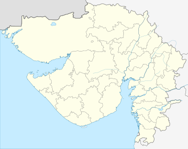
Porbandar
Porbandar ![]()
Porbandar Sudamapuri | |
|---|---|
City | |
 Hari Mandir Temple | |
 Porbandar  Porbandar | |
| Coordinates: 21°37′48″N 69°36′0″E | |
| Country | |
| State | Gujarat |
| District | Porbandar |
| Elevation | 1 m (3 ft) |
| Population (2011) | |
| • Total | 217,500 |
| Languages | |
| • Official | Gujarati |
| Time zone | UTC+5:30 (IST) |
| PIN | 360575 |
| Vehicle registration | GJ-25 |
| Website | www |
History
Harappan settlement (1600-1400 BCE)
Onshore explorations in and around Porbandar brought to light the remains of a late Harappan settlement dating back to the 16th-14th centuries BCE. There is evidence to suggest that the Harappan legacy of maritime activity continued till the late Harappan period on the Saurashtra coast. The discovery of ancient jetties along the Porbandar creek signifies the importance of Porbandar as an active center of maritime activities in the past.[1]
Indian theology views Porbandar as the birthplace of Sudama, the friend Krishna. For this reason, it is also referred to as Sudaamapuri or Sudamapuri.[1]
Princely Porbandar (1600 CE onwards)
Porbandar was the seat of the eponymous princely state in British India. In ancient times Porbandar was known to be Pao Bandar, due to its bread factories that used to export Pao ruti to Arab nations across Arabian sea. Colloquial changes in language results in name change to Pore Bandar
Later the state belonged to the Jethwa clan of Rajputs and had been established in the area since at least the mid-16th century. The state was subordinate to the Mughal governor of Gujarat until being overrun by the Marathas in the latter half of the 18th century. After, they came under the authority of the Gaekwad court at Baroda and eventually of the Peshwa.
British influence
In common with the other states of Kathiawar, the state first came into the ambit of British influence in 1807, when the HEIC guaranteed security in the area in lieu of a fixed annual tribute to be paid to the Peshwa and the Gaekwad. In 1817, the Peshwa ceded his share to the HEIC; in 1820, the Gaekwad agreed to have the HIEC collect his due tributes in Kathiawar and remit the same to his treasury.
During the British Raj, the state covered an area of 1,663 square kilometres (642 sq mi), encompassing 106 villages and a population, in 1921, of over 100,000 people. It enjoyed a revenue of Rs.21,00,000/-. By 1947, the rulers held the style of "Highness" and the title of "Maharaj Rana Sahib". They were entitled to a salute of 13 guns as a hereditary distinction.
After Independence
Upon the Independence of India in 1947, the state acceded to the dominion of India. It was merged with the 'United State of Kathiawar', effective 15 February 1948 and eventually came to form part of the present-day state of Gujarat. The last King of Porbandar was Natwarsinhji Bhavsinhji Maharaj.
Tourist attractions


The best time to visit is October to March.
- Kirti Mandir, a memorial of MK Gandhi (birthplace of Mahatma Gandhi) , built originally by Maharaja Sayaji Rao III in 1936 AD. It is located at the Main bazaar, Manek Chowk.
- Rana Bapu’s Mahal is located nearby Chowpati
- Bharat Mandir (A permanent exhibition of culture, history and geometry about India. It was established by Shri Nanjibhai Kalidas Mehta)
- Tara Mandir (one of the oldest planetariums of India)
- Ram Krishna Mission (Swami Vivekananda stayed here for four months)
- Shree Sudama ji Mandir: One of the few temples built in India in his name
- Shree Hari Mandir or Sandipani temple (handled by Ramesh Oza): a massive temple complex
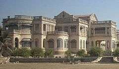
- The Huzoor Palace, Daria Raj Mahal Palace, Darbargadh and the Sartanji Choro
- Chowpati beach: one of the cleanest in coastal Gujarat
- Porbandar Bird Sanctuary (birds like teals, fowls, flamingos, ibis, curlews can be seen)
- Barda Hills Wildlife Sanctuary (about 15 km from Porbandar, ideal for trekking)
- Bileshwara Shiva temple (built in the 7th century)
- Khimeshwar Mahadev Temple (Kuchchdi) (1600-year-old temple as per the Archaeological Survey of India)
- Jamvant cave (15 km away at Ranavav town) (historical place from the time of Ramayan)[2]
- Ghumli (37 km from the city, Capital of Jethwa kingdom till 1313, listed by Archaeological Survey of India)
- Porbandar has many wetlands ideal for birdwatching.[3]
- Janmashtami Mela (5 days), celebrated in the month of Shraavana as per Hindu calendar. There are rides, foods, and other attractions.
Notable people
- Nanabhai Bhatt - film director and producer
- Mahatma Gandhi - considered as "The father of the Nation" was born here
- Dilip Joshi - actor (playing lead role as Jethalal Gada in Taarak Mehta Ka Ooltah Chashmah)
- Sudama - (also known as Kuchela) friend of Krishna
Current situation

As the birthplace of one of the most famous leaders of the world, Porbandar has a significant tourism-led infrastructure and economy. The area around Mahatma Gandhi's home has been renovated to become a temple of peace.
Porbandar's beach locally known as 'Chowpati' has a long, sandy expanse along the ocean. Construction activities to provide attractions and manage litter and facilities on Chowpati Beach started in around 2003. It has been furnished with well-arranged seating for tourists and commuters; there is a skating rink for children. The Chowpati ground has been used for the 'Janamastmi Fair', an annual festival. This place is well equipped with a circuit house and a range of hotels nearby for visitors.
Fisheries give a lot of employment to the city and to neighboring districts. Porbandar is also one of the last coasts remaining where the threatened marine mammal dugong can be found. Officials are working out for the conservation policies for the mammal.[4]
The current member of Parliament is ramesh dhaduk. The current member of the Gujarat Legislative Assembly is Babubhai Bokhiriya.
Geography
Porbandar is located at 21°37′48″N 69°36′0″E.[5] It has an average elevation of 1 metre (3 ft).
Climate
Like most of Gujarat, Porbandar has a hot semi-arid climate (Köppen BSh) with three distinct seasons: the “cool” from October to March, the “hot” in April, May and early June, and the monsoonal “wet” from mid-June to September.[6]
Almost no rain falls outside the monsoon season, except for a very few late-season tropical cyclones. The most powerful one occurred on 22 October 1975 and produced a storm surge of 4 metres or 13 feet. During the monsoon season, rainfall is exceedingly erratic: Annual rainfall has been as low as 32.2 millimetres or 1.27 inches in 1918 and 34.3 millimetres or 1.35 inches in 1939, but as high as 1,850.6 millimetres or 72.86 inches in 1983—when a cyclone caused over 1,100 millimetres (43.3 in) to fall over four days[7]—and 1,251.7 millimetres or 49.28 inches in 1878.
With a coefficient of variation exceeding fifty percent and an expectation of only 41 percent of mean annual rainfall in the driest year in ten, the Porbandar region is among the most variable in the world[8]—comparable to northern Australia, the Brazilian sertão and the Kiribatese Line Islands.[9]
An illustration of Porbandar’s extremely variable rainfall can be seen from 1899 to 1905 when seven successive years produced annual falls of:
- 83.4 millimetres (3.28 in) in 1899
- 1,185.1 millimetres (46.66 in) in 1900
- 99.8 millimetres (3.93 in) in 1901
- 756.9 millimetres (29.80 in) in 1902
- 575.2 millimetres (22.65 in) in 1903
- 124.5 millimetres (4.90 in) in 1904 and
- 134.4 millimetres (5.29 in) in 1905
Porbandar, owing to its coastal location, is the least hot of all major cities in Gujarat: Average high temperatures do not reach 32 °C or 90 °F in any month. Nonetheless, during the “wet” season, especially during the few but intense periods of heavy rainfall, very high humidity makes for extremely dangerous conditions; in the “hot” season temperatures reach 40 °C or 104.0 °F on occasions.
| Climate data for Porbandar | |||||||||||||
|---|---|---|---|---|---|---|---|---|---|---|---|---|---|
| Month | Jan | Feb | Mar | Apr | May | Jun | Jul | Aug | Sep | Oct | Nov | Dec | Year |
| Record high °C (°F) | 37.0 (98.6) |
40.0 (104.0) |
42.9 (109.2) |
43.1 (109.6) |
43.4 (110.1) |
44.5 (112.1) |
39.0 (102.2) |
39.0 (102.2) |
38.8 (101.8) |
42.0 (107.6) |
40.0 (104.0) |
37.2 (99.0) |
44.5 (112.1) |
| Average high °C (°F) | 26.6 (79.9) |
27.2 (81.0) |
29.7 (85.5) |
30.7 (87.3) |
31.5 (88.7) |
31.8 (89.2) |
30.0 (86.0) |
29.2 (84.6) |
29.5 (85.1) |
31.7 (89.1) |
31.4 (88.5) |
28.2 (82.8) |
29.8 (85.6) |
| Daily mean °C (°F) | 20.6 (69.1) |
21.6 (70.9) |
24.8 (76.6) |
26.8 (80.2) |
28.9 (84.0) |
29.5 (85.1) |
28.3 (82.9) |
27.4 (81.3) |
27.1 (80.8) |
24.3 (75.7) |
25.5 (77.9) |
22.2 (72.0) |
25.6 (78.0) |
| Average low °C (°F) | 19.3 (66.7) |
16.1 (61.0) |
19.9 (67.8) |
22.9 (73.2) |
26.3 (79.3) |
27.3 (81.1) |
26.7 (80.1) |
25.7 (78.3) |
24.8 (76.6) |
23.0 (73.4) |
19.6 (67.3) |
19 (66) |
22.6 (72.6) |
| Record low °C (°F) | 1.0 (33.8) |
2.0 (35.6) |
8.6 (47.5) |
13.0 (55.4) |
15.4 (59.7) |
6.0 (42.8) |
16.0 (60.8) |
12.0 (53.6) |
17.2 (63.0) |
16.0 (60.8) |
8.0 (46.4) |
7.0 (44.6) |
1.0 (33.8) |
| Average rainfall mm (inches) | 1 (0.0) |
1 (0.0) |
1 (0.0) |
0 (0) |
1 (0.0) |
106 (4.2) |
500 (19.7) |
151 (5.9) |
56 (2.2) |
14 (0.6) |
12 (0.5) |
1 (0.0) |
844 (33.1) |
| Source 1: Climate-Data.org (altitude: 629m)[6] | |||||||||||||
| Source 2: Voodoo Skies (records)[10] | |||||||||||||
Demographics

As of 2011 India census,[11] Porbandar had a population of 217,307. Males constituted 51.66% of the population and females 48.44%. Porbandar has an average literacy rate of 86.46%, higher than the national average of 74.04%: male literacy is 91.69%, and female literacy is 80.92%. In Porbandar, 9.11% of the population is under 6 years of age.
Porbandar has historical importance in context of one of the earliest Western Indian diaspora across the globe.. Thousands of Gujarati people in UK have origin in porbandar....Fiji and Australia and UK has significant " Girnara Soni" community who has roots in porbandar...Some people in Tanzania and Uganda have roots in Porbandar...Maher community popularly known as Mer has spread from porbandar to UK and USA before Decades...Some Lohana and Khoja Muslims have immigrated to South Africa..few to Madagascar...
Port
Porbandar is an ancient port city. At present it has an all-weather port, with direct berthing facilities up to 50,000 DWT ships.[12][13]
Transport
The local transportation is auto rickshaw. Sudama Chowk is the main hub of auto rickshaw and private taxis.
Porbandar is well-connected by road, rail and air to cities across the country.
Road

_Express_Route_map.jpg)
The city is connected through National Highway 27, connecting to Rajkot and Ahmedabad. National Highway 8E Ext (also known as State Highway 6) connects to Jamnagar, Dwarka in the north and Veraval, Bhavnagar in the south.
Major public transport is covered by the private and government buses.
Many private coaches are available daily to Rajkot, Dwarka, Veraval, Junagadh, Ahmedabad, Jamnagar, Vadodra, Surat, and Mumbai.
Large number of S.T. buses (State Transport Corporation operated by government) are available to multiple destinations including major cities of the state, small villages and towns.
From Narsang Tekri, you can catch luxurious air-conditioned private buses for Rajkot and Ahmedabad. The booking is available on the internet.
Rail
Porbandar railway station connects Porbandar with major cities of state and the country. There are daily trains to Rajkot (via Jamnagar, Bhanwad and Upleta, Dhoraji, Gondal as well), Somnath (via Junagadh) and Mumbai (via Ahmedabad, Vadodra and Surat). There are also trains to Delhi, Muzaffarpur and Howrah connecting to major cities of Rajasthan, Uttar Pradesh, Vidarbha and West Bengal. A weekly train service connects Kochuveli (Kerala) and Secunderabad (Hyderabad) with Porbandar via Mangalore, Calicut, Kochi and Quilon(Kollam).
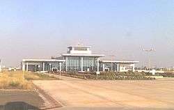
Airport
Porbandar Airport Mumbai-Porbandar to and fro flight by SpiceJet is currently operational.
Ahmedabad-Porbandar to and fro flight by TruJet is currently operational as well.
Sports
- Duleep School of Cricket Ground is one of two cricket grounds in Porbandar. The ground is also the home ground of Saurashtra cricket team. It hosted six cricket matches from 1968 to 1986 before falling of the record. The ground is named after great Indian cricketer and Prince of Nawanagar Kumar Shri Duleepsinhji.
- Natwarsinhji Cricket Club Ground is one of two cricket grounds in Porbandar. It hosted a Ranji Trophy match in October 1960 between Saurashtra cricket team and Maharashtra cricket team. The Maharashtra team won by 10 wickets as the match had a low scores with Saurashtra scored 94 & 139 and Maharashtra scored 187 and 47/0. It was scheduled for three days but was completed in two. This was only cricket played on the ground.
- Indian cricketer Jaydev Unadkat was born in Porbandar.
References
- A.S Gaur, Sundaresh, A.D. Odedra (2004). "New light on the maritime archaeology of Porbandar, Saurashtra Coast, Gujarat". Man and Environment. 29 (1): 103–107.CS1 maint: multiple names: authors list (link)
- https://porbandar.gujarat.gov.in/tourist-places/jambuvan-cave
- "Wetlands of Porbandar" (web). Mokarsagar Committee. Retrieved 31 March 2017.
- Kaushik, Himanshu. "Task force on dugong soon". Times of India. Retrieved 16 February 2016.
- Falling Rain Genomics, Inc - Porbandar
- "Porbandar - Climate graph, Temperature graph, Climate table". Climate-Data.org. Retrieved 29 October 2015.
- Francis P. A. and Sulochana Gadgil; ‘Intense Rainfall Events over the West Coast during the Summer Monsoon Season’ (CAOS REPORT 2002 AS 1); published by Centre for Atmospheric and Oceanic Studies; Indian Institute of Science, Bangalore
- Dewar, Robert E. and Wallis, James R; ‘Geographical patterning of interannual rainfall variability in the tropics and near tropics: An L-moments approach’; in Journal of Climate, 12; pp. 3457-3466
- Van Etten, Eddie J.B.; ‘Inter-annual Rainfall Variability of Arid Australia: greater than elsewhere?’ Australian Geographer; 40 (2009), pp. 109-120
- "Porbandar Monthly Temperature weather history". Voodoo Skies. Retrieved 29 October 2015.
- "Census of India 2011: Data from the 2011 Census, including cities, villages and towns (Provisional)". Census Commission of India. Archived from the original on 16 June 2004. Retrieved 1 November 2008.
- "Archived copy". Archived from the original on 7 October 2013. Retrieved 6 October 2013.CS1 maint: archived copy as title (link)
Sources
- for more details on Porbandar
- Jayesh Hinglajiya known as Modern Gandhi Sets World Record to change Body Colors
- Hemant Sharma, Artist and Photographer from Porbandar set World Record
- Genealogy of the ruling chiefs of Porbandar
- Application of geological and geophysical methods in marine archaeology and underwater explorations
- Porbandar district
External links
| Wikimedia Commons has media related to Porbandar. |

| Authority control |
|
|---|