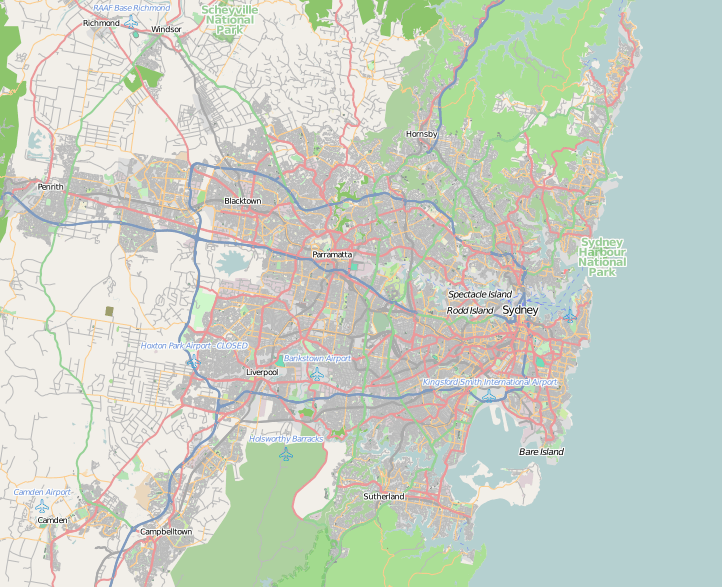
Cumberland Highway
The Cumberland Highway is a 34-kilometre (21 mi) long urban highway located in Sydney, New South Wales, Australia.[1][2] The highway links the Pacific Highway (A1/B83) and Pacific Motorway (M1) at Pearces Corner, Wahroonga in the northeast with the Hume Highway (A22/A28) at Liverpool in the southwest.[4]
Cumberland Highway | |
|---|---|
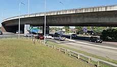
Pennant_Hills_Road_Thornleigh.jpg) | |
Cumberland Highway as the Pennant Hills Road at Thornleigh in 2016 | |
 NE end SW end | |
| Coordinates |
|
| General information | |
| Type | Highway |
| Length | 34 km (21 mi)[1][2] |
| Route number(s) |
|
| Former route number |
|
| Major junctions | |
| NE end | |
| |
| SW end | |
| Highway system | |
The entire length of Cumberland Highway is designated route A28.
The name of the highway is derived from the Cumberland Plain and Cumberland County. The name Cumberland was conferred on the County by Governor Phillip in honour of Ernest Augustus, Duke of Cumberland.[5]
History
The original western Sydney Bypass was Ring Road 5, which ran from the Pacific Highway and the Hume Highway with Parramatta in between. In 1974, Ring Road 5 was superseded by State Route 55. The growth of Sydney's west had instead turned it into a primary arterial with huge increase in freight traffic.
Metroad 7
In August 1988, the highway was finally completed to supersede the Church Street/Woodville Road route as the major connection between the Pacific and Hume Highways. The highway was named "Cumberland Highway" after completion.[6] State Route 77 was proclaimed and allocated to the entire length of the highway.
Metroad 7 replaced State Route 77 in June 1993 and the highway was designated by the Federal Government as an interim National Highway in 1994 until the completion of Westlink M7. When Metroad 7 was introduced, it went along Heathcote Road to the then Metroad 1 (now A1) at Heathcote. The southern section of Heathcote Road was replaced by the then Metroad 6 (now A6) in 1998, and Metroad 7 was therefore truncated to the end of Cumberland Highway at Liverpool.[7]
Since 1994, various parts of the Cumberland Highway were upgraded which included the widening of Pennant Hills Road.[6]
With the opening of the Westlink M7 motorway in December 2005, the Metroad 7 route south of M2 Hills Motorway was decommissioned and rerouted onto the Westlink M7, leaving only the section north of the M2 Hills Motorway to retain the Metroad 7 route marker. The Metroad 6 was extended northwards from Carlingford to join M2 Hills Motorway at the same time. This was the condition it had stayed until 2013.
With the introduction of alphanumeric routes in New South Wales, the entire Cumberland Highway was allocated the A28 route in May–June 2013 and Metroad 7 was completely decommissioned.[4]
Future developments
The NorthConnex, presently under construction with an expected completion date of 2019, will link the M2 Hills Motorway at West Pennant Hills with the Pacific Highway and Pacific Motorway at Wahroonga via a 9-kilometre (5.6 mi) motorway tunnel that aims to reduce congestion and improve traffic flow along the Pennant Hills Road section of the Cumberland Highway.[8]
Route
- Pennant Hills Road (from Wahroonga to North Parramatta)
- James Ruse Drive (from North Parramatta to Northmead)
- Briens Road
- Old Windsor Road
- Hart Drive
- Freame Street
- Emert Street
- Jersey Road
- Betts Road
- Warren Road
- Smithfield Road
- Palmerston Road
- New Cambridge Street
- Cambridge Street
- Joseph Street
- Orange Grove Road
- Hume Highway (from Liverpool to Prestons)
Exits and interchanges
| LGA | Location | km | mi | Destinations | Notes |
|---|---|---|---|---|---|
| Hornsby | Wahroonga | 0.0 | 0.0 | North-eastern terminus; continues northeast as the Pacific Motorway | |
| 0.0 | 0.0 | North-eastern terminus; exits north and south as the Pacific Highway | |||
| 0.0 | 0.0 | ||||
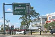
| The Hills | Pennant Hills | 5.0 | 3.1 | Beecroft Road – Beecroft, Epping | Southbound and northbound exits only |
| 5.3 | 3.3 | Beecroft Road – Beecroft, Epping | Southbound and northbound entrances only | ||
| West Pennant Hills | 6.7 | 4.2 | Castle Hill Road – Castle Hill, Windsor | ||
| 7.9 | 4.9 | ||||
| Parramatta | Carlingford | 10.5 | 6.5 | Pennant Hills Road continues southwest | |
| North Parramatta | 14.7 | 9.1 | |||
| 14.7 | 9.1 | Pennant Hills Road – North Parramatta, Parramatta | Pennant Hills Road continues without A28 designation | ||
| Northmead | 16.3 | 10.1 | Windsor Road – Windsor Church Street – Parramatta | ||
| 17.5 | 10.9 | Briens Road – Westmead to Westmead and Children's hospitals | |||
| 18.0 | 11.2 | ||||
| Wentworthville | 19.5 | 12.1 | Darcy Road to Westmead and Children's hospitals | ||
| 21.0 | 13.0 | ||||
| 21.2 | 13.2 | ||||
| Cumberland | Smithfield | 26.2 | 16.3 | The Horsley Drive – Fairfield, Wetherill Park to Westlink M7 | |
| Fairfield | 27.6 | 17.1 | Polding Street – Fairfield, Prairiewood Smithfield Road – Edensor Park | No southbound access to Smithfield Road | |
| Cabramatta West | 32.1 | 19.9 | Cabramatta Road West – Cabramatta, Bonnyrigg to Westlink M7 | ||
| Liverpool | Liverpool | 34.0 | 21.1 | South-western terminus; continues southwest as the Hume Highway | |
| 34.0 | 21.1 | South-western terminus; exits northeast as the Hume Highway | |||
See also
References
- "17 Pennant Hills Road, Wahroonga NSW 2076 to Cumberland Highway, Liverpool NSW 2170". Google Maps. Google Inc. 2016. Retrieved 24 October 2016.
- "Map of Cumberland Highway, NSW". Bonzle Digital Atlas of Australia. Retrieved 23 October 2016.
- "Former NSW State Route 53". Ozroads. Retrieved 8 June 2013.
- "Cumberland Highway". Ozroads. Retrieved 23 October 2016.
- "Cumberland". Geographical Names Register (GNR) of NSW. Geographical Names Board of New South Wales. Retrieved 4 August 2013.

- "Cumberland Highway History". Ozroads. Retrieved 8 June 2013.
- "Metroad 7". Ozroads. Retrieved 9 June 2013.
- "NorthConnex". NorthConnex - About. Retrieved 28 April 2015.
External links
- "M4 Smart Motorways: Proposed changes to Cumberland Highway interchange" (PDF) (Map). Roads & Maritime Services. Government of New South Wales.