Bradfield Highway (Sydney)
The Bradfield Highway is a highway in Sydney, New South Wales, Australia. At 2.5 kilometres (1.6 mi)[1] long it is one of the shortest highways in Australia.
Bradfield Highway | |
|---|---|
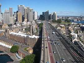 | |
Bradfield Highway, south-westerly aspect | |
| General information | |
| Type | Highway |
| Length | 2.5 km (1.6 mi)[1] |
| Opened | 1932 |
| Gazetted | 19 March 1932[2] |
| Maintained by | Roads & Maritime Services |
| Former route number | |
| Major junctions | |
| North end | |
| South end |
|
| Highway system | |
The highway was opened on 19 March 1932 and was named in honour of Dr John Bradfield. As a government-appointed civil engineer, Bradfield oversaw the tendering process for the construction of the Sydney Harbour Bridge, and as the NSW Public Works Department chief engineer had oversight of the bridge design and construction. Amid some controversy, Bradfield was also considered to be the co-designer of the bridge's arch design, along with Dorman Long and Sir Ralph Freeman.[2][5][6][7]
Route
The southern terminus of the Bradfield Highway is at the northeastern end of the Western Distributor in the Sydney central business district and crosses the Sydney Harbour Bridge, with its northern terminus at the Warringah Freeway in North Sydney, north of the Pacific Highway exit at the Mount Street ramp. Prior to the construction of the Warringah Freeway in 1968, all traffic at the northern terminus of the Bradfield Highway was directed to or from the Pacific Highway, via North Sydney.[5]:Construction of the Warringah Freeway (image)
The Bradfield Highway currently carries six lanes of traffic across the eight lane Sydney Harbour Bridge. The other two traffic lanes on the Sydney Harbour Bridge are used for the Cahill Expressway, which run only southbound on the bridge. During peak periods three out of the six lanes are reversed, giving a 2 × 4, 3 × 3 or 5 × 1 flow. The default is 4 × 2, being four north lanes and two south lanes (with the additional two lanes of the Cahill Expressway providing an even flow of traffic). The direction of the lanes is indicated by electronic signage above each lane. The lanes are numbered one to six from west to east. Lane six was also reversed prior to 1990 during the evening rush hour, giving a 6 × 0 flow, however this no longer occurs because of changes made to the Warringah Freeway to accommodate the Sydney Harbour Tunnel.
In 2001, 159,587 vehicles a day used the highway.[8]
In August 1992 the Sydney Harbour Tunnel opened which helped to relieve congestion on the Bradfield Highway.[9]
The Bradfield Highway is a designated stock route.[10]
Road toll
A road toll is levied on all vehicles travelling across the Sydney Harbour Bridge, via the Bradfield Highway or the Cahill Expressway in a southerly direction only. A toll also applies for vehicles travelling in the same direction using the Sydney Harbour Tunnel. In November 2014 NSW Roads & Maritime Services proposed an to upgrade the tolling infrastructure which included the construction new tolling gantries at four locations on the northern approaches to the bridge, covering the Bradfield Highway, Cahill Expressway and the Sydney Harbour Tunnel, and the removal of existing tolling gantries at both the northern and southern bridge termini.[11]
Exits and interchanges
| LGA | Location | km[1] | mi | Destinations | Notes |
|---|---|---|---|---|---|
| North Sydney | North Sydney | 0 | 0.0 | Includes access from Military Road, Falcon Street and the Gore Hill Freeway | |
| Mount Street – North Sydney | Southbound entrance only. | ||||
| 0.4 | 0.25 | Pacific Highway – North Sydney, Chatswood, Artarmon | Northbound exit only. Access from Pacific Highway to the Bradfield Highway from the north is via Mount Street or Falcon Street | ||
| Milsons Point | 0.5 | 0.31 | Lavender Street – Milsons Point, McMahons Point, Kirribilli and Luna Park | Northbound exit only. | |
| Port Jackson | 1 | 0.62 | Sydney Harbour Bridge (Toll on southbound carriage only) | ||
| Sydney | Sydney CBD | 2.5 | 1.6 | Bradfield Highway continues south as the Western Distributor | |
| Cahill Expressway – The Domain | Northbound entrance only | ||||
| York Street – Sydney central business district | Southbound exit only | ||||
| Clarence Street – Sydney central business district | Northbound entrance only | ||||
| Grosvenor Street – Sydney central business district | |||||
1.000 mi = 1.609 km; 1.000 km = 0.621 mi
| |||||
See also
![]()
References
- "Warringah Fwy & Mount St & Bradfield Hwy & Arthur St, New South Wales to Sydney Harbour Bridge". Google Maps. 2016. Retrieved 26 December 2016.
- Spearritt, Peter (1979). "Bradfield, John Job Crew (1867–1943)" (hardcopy). Australian Dictionary of Biography. National Centre of Biography, Australian National University. Retrieved 26 December 2016.
- Sydney Harbour Crossings, Ozroads, Retrieved on 3 June 2013.
- Former Alignment of Metroad 2, Ozroads, Retrieved on 3 June 2013.
- "Sydney Harbour Bridge". Sydney Architecture. Retrieved 26 December 2016.
- Department of Environment and Heritage. "Draft nomination for Sydney Harbour Bridge" (PDF). National Heritage List: Nomination Form. Engineers Australia. Retrieved 26 December 2016.
- "Australian Heritage Database: National Heritage List: Sydney Harbour Bridge". Department of the Environment. Australian Government. 30 January 2007. Retrieved 26 December 2016.
- "Sydney Harbour Bridge page". Retrieved 5 June 2013.
- "The Sydney Harbour Tunnel". Air Quality in Tunnels. New South Wales, Australia: NSW Government: Transport, Roads & Maritime Services. p. 9. RMS 12 178. Retrieved 5 June 2013.
- "NSW drovers rally to save historic travelling stock routes". Wilderness Society. 27 August 2008. Archived from the original on 26 December 2016. Retrieved 26 December 2016.
- "Have your say: Sydney Harbour Bridge Tolling Systems Upgrade" (PDF). Roads & Maritime Services. NSW Government. November 2014. Retrieved 26 December 2016.
External links
- De Berquelle, Raymond (1967). The recently completed Bradfield Highway, North Sydney, New South Wales (Colour photograph). National Library of Australia.
- "Bridging Sydney: Educational Resource Kit" (PDF). Historic Houses Trust. NSW Government.