Bathurst Street, Sydney
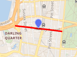
Bathurst Street is a street in the Sydney central business district in New South Wales, Australia. Bathurst Street runs for 650 metres (2,130 ft) in a west–east direction with traffic flowing in this direction only.[1][2] It is situated in the southern portion of the central business district. The western terminus of Bathurst Street is at Harbour Street, Darling Harbour, with the eastern terminus at Elizabeth Street, adjacent to Hyde Park.
Bathurst Street | |
|---|---|
 | |
Bathurst Street | |
| |
 West end East end | |
| Coordinates |
|
| General information | |
| Type | Street |
| Length | 650 m (0.4 mi)[1] |
| Major junctions | |
| West end | Harbour Street, Sydney |
| East end | Elizabeth Street |
From west to east, Bathurst Street crosses Sussex, George, Pitt, and Castlereagh streets.
Bathurst Street was named by Governor Macquarie in honour of Henry Bathurst, 3rd Earl Bathurst, the UK Secretary of State for War and the Colonies between 1812 and 1827.[3][4] In conjunction with the opening of the Glebe Island Bridge, in December 1995 a bus lane was opened from Habour to George Streets.[5]
Landmarks
- The Hyde Park Obelisk, at the eastern end of Bathurst Street, was erected in 1857 and unveiled by the Mayor, George Thornton. The monument is actually a sewer vent, and soon the joke around town was to call it 'Thornton’s Scent Bottle'.[6] The obelisk is an example of the Victorian Egyptian style and was based on Cleopatra's Needle in London.[7]:99 It is listed on the NSW State Heritage Register.[8]
- The Church of England St Andrew's Cathedral sits on the north-west corner of Bathurst Street and George Street. It was designed by Edmund Blacket and was listed on the Register of the National Estate.[7]:100
- The former Bank of New South Wales building sits on the south-west corner of Bathurst Street and George Street. It was designed by Varney Parkes and built in 1894 in the American Romanesque style. It is listed on the NSW State Heritage Register.[9][7]:101
- The Vintage building is situated on the corner of Bathurst and Sussex Streets. It was built in the 1890s and was just one of many warehouses that sprang up in the area because of its proximity to Darling Harbour. It was used as a flour mill while owned by Aitken and Son; later owners included Mungo Scott Ltd. In 1979 it was converted to apartments.
Gallery
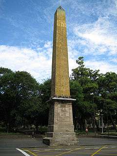 Hyde Park Obelisk
.JPG) The Vintage Building
The Vintage Building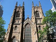 St Andrew's Cathedral, west side
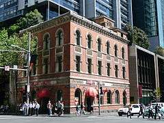 Former Bank of New South Wales
References
- Bathurst St, Sydney NSW 2000 to 120 Elizabeth St, Sydney NSW 2000 (Map). Google Maps. 2016. Retrieved 27 December 2016.
- Maps C, D (Map). Gregory's Sydney Street Directory. 2002.
- "What's in a name?". Sydney Streets. City of Sydney. 2003. Archived from the original on 30 December 2016. Retrieved 29 December 2016.
- "History of Sydney Streets" (MS Excel (for download)). Sydney Streets. City of Sydney. 4 December 2012. Retrieved 29 December 2016.
- Central City Bus Priority Scheme Australian Bus Panorama issue 13/1 August 1997 page 33
- "Thornton's Scent Bottle". Water Supply and Sewerage. City of Sydney.
- Australian Heritage Commission (1981), The Heritage of Australia: the illustrated register of the National Estate, South Melbourne: The Macmillan Company of Australia in association with the Australian Heritage Commission, ISBN 978-0-333-33750-9
- "Sewer Vent". NSW State Heritage Register. Office of Environment & Heritage, Government of New South Wales. 30 November 2001. Retrieved 27 December 2016.
- "Bank of NSW". NSW State Heritage Register. Office of Environment & Heritage, Government of New South Wales. 5 September 2008. Retrieved 27 December 2016.