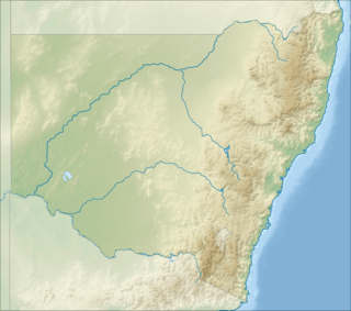
Pacific Motorway (Sydney–Newcastle)
The M1 Pacific Motorway, also known by the former names F3 Freeway, Sydney–Newcastle Freeway, and Sydney–Newcastle Expressway; is a 127 km (79 mi) stretch of motorway linking Sydney to the Central Coast, Newcastle and Hunter regions of New South Wales. It is part of the AusLink road corridor between Sydney and Brisbane. The name "F3 Freeway", reflects its former route allocation, but is commonly used by both the public and the government to refer to the roadway long after the route allocation itself was no longer in use.[5]
M1 Pacific Motorway F3 Freeway / Sydney–Newcastle Freeway / Sydney–Newcastle Expressway | |
|---|---|
 | |
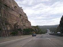
View northbound at Berowra | |
 SSW end NNE end | |
| Coordinates |
|
| General information | |
| Type | Motorway |
| Length | 127.1 km (79 mi) |
| Opened | 15 December 1965 |
| Gazetted | 1 February 2013[1][2] |
| History | Further stages opened up until 1998 |
| Route number(s) |
|
| Former route number | |
| Major junctions | |
| SSW end | |
Bobbin Head Road
| |
| NNE end |
|
| Location(s) | |
| Major suburbs / towns | |
| Highway system | |
Route
At its southern end, the freeway starts at Pennant Hills Road, Wahroonga, near its junction with the Pacific Highway (Pearces Corner) in Sydney's north. It heads north, skirting the western edge of the Ku-ring-gai Chase National Park, running parallel with the railway line until it descends to the Hawkesbury River, crossing at Kangaroo Point in Brooklyn. Immediately north of the river, the Hawkesbury River interchange provides access to Brooklyn and Mooney Mooney before the road climbs. At Mount White there are major heavy vehicle checking stations on both northbound and southbound carriageways, to assess compliance and roadworthiness of trucks.
The freeway passes through the Brisbane Water National Park, and the Calga interchange gives access to Peats Ridge. The freeway then turns east to cross Mooney Mooney Creek by way of the 480 m (1,575 ft) long, 75 m (246 ft) high Mooney Mooney Bridge before it reaches the first major interchange on the Central Coast at Kariong.
After Kariong, the freeway continues through rural and semi-rural areas of the Central Coast with interchanges at Ourimbah, Tuggerah, Warnervale and Kiar, near Doyalson. From the Doyalson interchange the freeway continues to the west of Lake Macquarie with interchanges near Morisset, Cessnock, Toronto and West Wallsend.
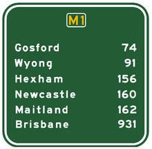
At the West Wallsend interchange the Newcastle Link Road (A15) takes traffic into Newcastle via Wallsend and also connects with the M15 Hunter Expressway towards Kurri Kurri and Singleton, while the freeway continues north to end at the signalised intersection at the junction of Weakleys Drive and John Renshaw Drive, Beresfield. Prior to November 2018, the intersection was a roundabout and conversion and upgrade works was completed in March 2019.[6][7] From here traffic bound for Highway 1 takes John Renshaw Drive and the New England Highway eastwards to meet the Pacific Highway at Hexham, and Weakleys Drive connects with the New England Highway towards Maitland.
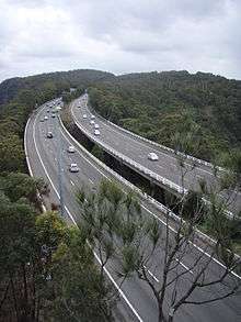
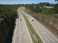
Between Wahroonga and Ourimbah the freeway passes through rugged sandstone country, particularly as it descends to and ascends from the Hawkesbury River. This section of the freeway is characterised by deep cuttings and extensive embankments.
History
Planning for the freeway began in 1952, with the aim of providing a high-speed replacement for a section of the Pacific Highway that had been built in 1925–30 which was struggling to cope with the increased traffic. It was planned that the freeway would connect to the freeway systems being proposed for both Sydney and Newcastle, providing a city-to-city freeway link.
The route between Mount White and Kariong was originally planned to be further south than the route as built, with an easier crossing of Mooney Mooney Creek. By the time that construction on this section was to begin, resistance from the National Parks & Wildlife Service to the proposed route forced the Department of Main Roads to take a route through Calga, using part of the first stage of a proposed freeway route to Singleton which had been built the 1960s. That scheme has never been further developed.
The route through Wyong Shire also changed; instead of passing east of Wyong along the western edge of the Tuggerah Lakes, development in that area forced the freeway to be moved to the west of Wyong, with link roads being constructed to meet the Pacific Highway near Doyalson and Tuggerah.
In addition, the freeway was revised to go to the west of Lake Macquarie rather than the east, and thereby bypass Newcastle. One of the reasons for this change of location was the issue of connectivity to the Pacific Highway north of Newcastle, as the route of the Newcastle Inner City Bypass, which would have provided a northern extension of the freeway, is problematic in terms of its northern terminus point at Sandgate not easily allowing for a northward freeway-standard route to join to the Pacific Highway.
The sections of the Newcastle Inner City Bypass from the Pacific Highway at Bennetts Green to Kotara and from Jesmond to Sandgate have since been constructed, while the original freeway route between Belmont and Bennetts Green and then northward to the Pacific Highway at Merewether Heights is still reserved from development, with the possibility that it could be constructed in the future.
The major stages in the construction of the freeway were:[8]
- April 1963 – Construction began on the 7 km (4 mi) section from the Hawkesbury River to Mount White. This was opened as a toll road in December 1965.
- October 1966 – Opening of the Mount White-Calga section (including first section of proposed freeway to link to the New England Highway at Singleton).
- December 1968 – Opening of Berowra to Hawkesbury River section as a toll road.
- October 1973 – Completion of the Brooklyn Bridge, thereby connecting the Berowra-Hawkesbury River and Hawkesbury River-Calga sections. At this time the separate tolls for the sections north and south of the Hawkesbury (20 cents for each section) were abolished and a single toll of 50 cents was introduced. This was collected at the Berowra toll booths, and the Mooney Mooney toll booths were removed. The toll was removed in 1990 when the Federal Government adopted a policy that a condition of its direct funding of the national highways was that they were to be toll free.
- December 1983 – Concurrent opening of the Somersby to Ourimbah and Kangy Angy to Wallarah Creek sections, including the single carriageway motorway link from Wallarah Creek to the Pacific Highway at Doyalson.
- December 1986 – Opening of the 15 km (9 mi) section between Calga and Somersby including the Mooney Mooney Bridge.
- September 1987 – Freeway completed from Wallarah Creek interchange to Mandalong Road interchange.
- March 1988 – Freeway completed from Mandalong Road interchange to Freemans Waterhole interchange.
- March 1989 – Wahroonga to Berowra section opened[9]
- December 1990 – Section from Freemans Waterhole Interchange to Palmer's Road completed.
- December 1993 – Palmer's Road to Minmi section opened.
- December 1997 – "Missing link" between Ourimbah and Kangy Angy opened.
- November 1998 – Final stage of freeway opened between Minmi and John Renshaw Drive, Beresfield.
The motorway has also undergone several upgrades:
- December 2004 – Completion of widening to six lanes of the four-lane sections between the Hawkesbury River and Calga. As part of this work, a new south bound truck weighing station was built at Mount White to replace the facility at Berowra. The station was built on the existing two-lane alignment, and a new three-lane south bound alignment was built for car traffic.
- November 2009 – Completion of widening to six lanes of the four-lane sections between Wahroonga and the Hawkesbury River, resulting in a continuous six lane width over the 43 km (27 mi) from Wahroonga to Kariong.[10] This work was completed in three stages; stage 1 – Cowan to Berowra (3.4 km (2 mi)), completed September 2008, stage 2 – Berowra to Mount Kuring-Gai (4.9 km (3 mi)), completed September 2009) and stage 3 – Mount Kuring-Gai to Mount Colah (4.2 km (3 mi)), completed November 2009.
- August 2013 – road signs were changed to show the new M1 marker and the new name "Pacific Motorway" as part of a new statewide alpha numeric route scheme.[5]
- March 2019 – Replacement of the roundabout on Pacific Motorway, John Renshaw, and Weakleys Drives with a signalised intersection.[6][7]
- May 2020 - Completion of widening the Pacific Motorway to three lanes in each direction from Kariong to Somersby.[11][12][13]
- June 2020 - Completion of Widening the Pacific Motorway to three lanes in each direction from Tuggerah to Doyalson.[14][15][13]
"F3" designation

In addition to the National Highway 1 designation, the freeway at one stage carried the Freeway Route 3 (F3) designation. This route numbering system, introduced in 1971, was to provide distinctive route numbering and signage for freeways in Sydney and the surrounding areas. Although the route was never signed with the F3 route marker (the numbering system was removed in the late 1980s), the route is still often referred to as the F3 Freeway, with this title being used not only colloquially but on state and federal government documents and web sites and some road signs.
Proposed upgrades and connections

Strong public resistance in the 1970s to freeways being constructed within cities and unfavourable outcomes of government inquiries resulted in several freeway proposals in Sydney being abandoned. This included the connecting the Lane Cove Valley and North Western Expressways, which means that the Pacific Highway (a six lane urban arterial) continues to be the connecting route between the freeway's southern terminus at Wahroonga and the city centre.
However plans are currently being developed for extensions at both ends of the M1:
- The Federal Government supports the concept of a Sydney Bypass proposal, being a motorway connecting the M1 Pacific Motorway at Wahroonga with the M7 and thus the Hume Highway, leading southwest from Sydney towards Canberra and Melbourne. It has funded studies to identify options for such a connection. It will be a pair of tunnels connecting the Motorway at Pearces Corner, Wahroonga to the M2 Motorway near the Pennant Hills Road interchange.[16] Due to community concern, Mahla Pearlman carried out an independent review which was completed in August 2007. The review concluded that the proposed tunnels should proceed as proposed under Pennant Hills Road, but urged that planning for the longer term connection between the F3 and the M7 should also commence immediately.[17] On 16 March 2014, the preferred contractor for construction of the NorthConnex link was announced.[18]
- As part of the upgrade of the Pacific Highway between Hexham and the New South Wales/Queensland border, a freeway extension is proposed to be constructed between the F3 at Black Hill (close to its current northern terminus) and the Raymond Terrace bypass.[19] This section is currently a major bottleneck during holiday and long weekend periods, with delays lasting hours not uncommon. The layout of the twin bridges across the Hunter River at Hexham was designed primarily for local traffic to and from Newcastle, rather than to connect the Pacific Highway north of Newcastle to the freeway. This freeway extension is not anticipated to be constructed until after 2026.[20]
Traffic disruption
Other than the Pacific Highway, which the freeway has superseded, the freeway is the only direct route between Sydney and the Central Coast, and is the major road route for road transport from Sydney to the Hunter region, northern NSW and Queensland. The freeway thus carries a heavy mix of commuter traffic, road freight transport, and (periodically) holiday and recreational travellers. It often suffers from traffic disruptions, generally associated with traffic volume and congestion related to on-road breakdowns and vehicle accidents, or natural disasters (in particular, bushfire).[21][22]
In addition traffic on the freeway is frequently affected by vehicle crashes, often involving trucks.[23][24] These events have encouraged the NSW motoring organisation NRMA to call for more freight to be moved by rail to reduce the number of trucks using the freeway.[25]
Bushfires have caused closure of the freeway and the nearby railway line and Pacific Highway between Sydney and the Hawkesbury River on a number of occasions. One such event of this type was recorded on 21 and 22 January 2007, when a fire broke out in the adjoining Kuring-gai Chase National Park. The fire forced the closure of the two roads and the railway line between Sydney and the Central Coast, resulting in extended disruption to traffic flow.
Because of the frequency of these disruptions to traffic flow, arguments for a second major freeway north from the Sydney metropolitan area continue to be pushed forward.[17][26] However topography and resultant cost rules this out for practical purposes, other than indirect routes crossing the Hawkesbury in the vicinity of Wiseman's Ferry, some 30 km upstream of the current crossing.
Following criticism of significant delays due to accidents and blockages,[27] the NSW Roads and Traffic Authority (RTA) is in the process of constructing a $28 million emergency plan for the freeway which involves development of a 40 km/h contraflow traffic scheme to allow vehicles to travel around an accident.[28]
Traffic volume
The Annual average daily traffic (AADT) data from the Roads & Traffic Authority showed a decline in traffic volume on the freeway near its southern end at Wahroonga, from 78,600 in 2002 to about 76,600 in 2005 and then to 75,800 in 2006.[17]
The 2004 AADT figures for other locations on the freeway include 73,400 at Mooney Mooney, just north of the Hawkesbury River bridge, 60,100 near Wyong, 38,500 near Wyee, 27,000 near Freemans Waterhole and 33,000 near its northern terminus at Beresfield.[29]
Interchanges
| LGA | Location | km | mi | Destinations | Notes |
|---|---|---|---|---|---|
| Hornsby Shire | Wahroonga | 0.0 | 0.0 | ||
| Hornsby Shire / Ku-ring-gai Council | Wahroonga | 0.1 | 0.062 | Wahroonga Interchange – A Half-diamond interchange; northbound on and southbound off only | |
| Hornsby Shire | Mount Colah | 4.8 | 3.0 | Ku-Ring-Gai Chase Road | Mount Colah Interchange – A Half-diamond interchange; northbound off and southbound on only |
| Berowra | 10.5 | 6.5 | Windybanks Interchange – A Half-trumpet interchange; northbound off and southbound on only | ||
| Cowan | 14.2 | 8.8 | Berowra Interchange – A partial Y interchange | ||
| Central Coast | Mooney Mooney | 24.1 | 15.0 | Hawkesbury River Interchange – A controlled offset dumbbell interchange | |
| Mount White | 32.3 | 20.1 | Mount White Interchange – A trumpet interchange | ||
| Calga | 37.7 | 23.4 | Calga Interchange | ||
| Somersby | 44 | 27 | Kariong Interchange – A partial Y/Half diamond interchange; the entry point to the Central Coast. | ||
| 50.9 | 31.6 | Peats Ridge Road | Somersby Interchange – A trumpet interchange | ||
| Ourimbah | 57.4 | 35.7 | Pacific Highway | Ourimbah Interchange - A dumbbell interchange | |
| Mardi / Tuggerah | 62.9 | 39.1 | Tuggerah Interchange – A partial dumbbell interchange with a loop northbound | ||
| Halloran / Jilliby / Wallarah | 72 | 45 | Warnervale Interchange – A diamond interchange with a loop northbound; connected to the Wallarah Creek Interchange. | ||
| Halloran / Jilliby / Kiar / Wallarah | 74.5 | 46.3 | Wallarah Creek Interchange – A partial Y interchange; connected to the Warnervale Interchange. | ||
| City of Lake Macquarie | Morisset | 86.5 | 53.7 | Morisset Interchange – A diamond interchange | |
| Cooranbong | 99.3 | 61.7 | Freemans Waterhole Interchange – A Half-diamond interchange | ||
| Freemans Waterhole | 103 | 64 | Cessnock Road | Awaba Interchange – A diamond interchange | |
| West Wallsend | 116 | 72 | West Wallsend Interchange – A Half-diamond interchange with one roundabout | ||
| Cameron Park | 118 | 73 | Newcastle Interchange – A stack interchange with a loop northbound; not to be confused with Newcastle Interchange | ||
| City of Newcastle | Black Hill | 124 | 77 | Lenaghans Drive | Black Hill Interchange |
| Beresfield / Black Hill | 127 | 79 | Weakleys Drive to Maitland (14 km) and Brisbane (836 km) | 4-way signalised intersection | |
| 1.000 mi = 1.609 km; 1.000 km = 0.621 mi | |||||
See also
- The F3 Derby
- Freeways in Australia
- Freeways in New South Wales
References
- Government Gazette of NSW 1 February 2013 Page 8 Archived 28 April 2013 at the Wayback Machine, NSW Government, Retrieved on 6 June 2013.
- Government Gazette of NSW 1 May 2013 Page 15 Archived 3 January 2015 at the Wayback Machine, NSW Government, Retrieved on 6 June 2013.
- "Archived copy". Archived from the original on 27 November 2016. Retrieved 26 November 2016.CS1 maint: archived copy as title (link) Ozroads: Sydney-Newcastle Freeway – Construction Information
- "Archived copy". Archived from the original on 3 April 2015. Retrieved 24 March 2015.CS1 maint: archived copy as title (link) Ozroads: NSW Freeway Routes
- "Next round of alphanumeric signs to be updated". Roads and Maritime Services. 13 August 2013. Archived from the original on 16 August 2013. Retrieved 16 August 2013.
- McKinney, Max (3 December 2018). "Hunter intersection leaves roundabout behind with new traffic lights". Newcastle Herald. Retrieved 9 December 2019.
- "M1 Pacific Motorway Upgrades - Weakleys Drive and John Renshaw Drive intersection". Transport for NSW - Roads and Maritime. Archived from the original on 9 December 2019. Retrieved 13 March 2020.
- "Sydney-Newcastle Freeway". NSW Roads & Traffic Authority. 20 June 2006. Archived from the original on 2 March 2008. Retrieved 9 January 2008.
- Mary Boson and Nicole Taylor (23 March 1989). "Motorists Rejoice as Bypass Opens". The Sydney Morning Herald. Retrieved 17 August 2013.
- "Archived copy". Archived from the original on 15 June 2006. Retrieved 6 July 2006.CS1 maint: archived copy as title (link) RTA F3 Project Information
- "M1 Pacific Motorway Upgrades – Kariong to Somersby". Transport for NSW. Retrieved 9 December 2019.
- "M1 Pacific Motorway upgrade between the Kariong and Somersby interchanges" (PDF). Transport for NSW - Roads and Maritime. Roads and Maritime Services. May 2014. Retrieved 14 June 2020.
- "M1 Pacific Motorway Upgrades - Community update – Projects completed" (PDF). Transport for NSW - Roads and Maritime. Transport for NSW. June 2020. Retrieved 14 June 2020.
- "M1 Pacific Motorway Upgrades – Tuggerah to Doyalson". Transport for NSW. Retrieved 9 December 2019.
- "M1 Pacific Motorway widening between the Tuggerah and Doyalson interchanges" (PDF). Transport for NSW - Roads and Maritime. Roads and Maritime Services. August 2014. Retrieved 14 June 2020.
- "Archived copy". Archived from the original on 2 September 2007. Retrieved 3 March 2007.CS1 maint: archived copy as title (link) Federal minister's press release
- Pearlman review of F3 to M7 Corridor Selection, published August 2007 Archived 17 September 2007 at the Wayback Machine
- "Transurban announces preferred contractor for NorthConnex" (PDF). Transurban. Archived from the original (PDF) on 16 March 2014.
- "Archived copy". Archived from the original on 29 September 2007. Retrieved 21 October 2006.CS1 maint: archived copy as title (link) F3 to Pacific Highway route study
- Minmi/Link Road and Stockrington Concept Plan, Page 102 Archived 23 April 2013 at the Wayback Machine, Coal & Allied Industries, Retrieved on 31 December 2013.
- "Archived copy" (PDF). Archived from the original (PDF) on 29 August 2007. Retrieved 21 November 2007.CS1 maint: archived copy as title (link) Auslink Sydney Brisbane Corridor Strategy, p15
- Faulks, I.J., Irwin, J.D., Tynan, D., Dabbas, W.M., Sweedler, B. & Stewart, K., (2009). Motorways and heavy vehicle safety: The F3 Sydney – Newcastle Freeway. Paper presented to the NSW Department of Emergency Services seminar on the F3 Freeway Heavy Vehicle Safety and Emergency Management, held at Berowra NSW, Saturday 27 June 2009.
- "F3 closed: third smash in four days". abc.net.au. 1 February 2008. Archived from the original on 14 February 2009. Retrieved 7 May 2018.
- The Age news story on crash 31 January 2008 Archived 3 February 2008 at the Wayback Machine
- "Trucks face ban on F3 Highway to Hell – Daily Telegraph, 31 January 2008". news.com.au. Archived from the original on 19 March 2008. Retrieved 7 May 2018.
- "Truck smash causes freeway frustration – National – smh.com.au". www.smh.com.au. Archived from the original on 26 November 2015. Retrieved 7 May 2018.
- "RTA 'bungled truck inferno reaction'". abc.net.au. 30 January 2008. Archived from the original on 14 February 2009. Retrieved 7 May 2018.
- http://163.189.7.150/constructionmaintenance/majorconstructionprojectsregional/centralcoast/f3/f3_tmp.html%5B%5D F3 Freeway emergency traffic management plan
- "Archived copy" (PDF). Archived from the original (PDF) on 5 August 2008. Retrieved 5 April 2009.CS1 maint: archived copy as title (link) NSW RTA AADT for Northern region including Hunter, 2004
External links
- Sydney-Newcastle Freeway at Ozroads Detailed site containing many existing and historical images.
- Live Traffic NSW F3 Traffic Cameras
- Pacific Motorway NSW Traffic Incident alerts & detailed traffic for the Sydney-Newcastle Pacific Motorway
| ||
Road infrastructure in regional New South Wales | ||
|---|---|---|
| Motorways | ||
| Major highways | ||
| Minor highways | ||
| Other roads |
| |
| Road bridges (disused/former) |
| |
| Vehicular ferries | ||
| Tunnels | ||