M4 Motorway (Sydney)
The M4 Motorway is a 50.2-kilometre-long (31.2 mi)[1] dual carriageway partially tolled motorway in Sydney, New South Wales, Australia that is designated with the M4 route. The M4 designation is part of the wider A4 and M4 route designation, the M4 runs parallel/below ground to the Great Western Highway and Parramatta Road.
M4 Motorway | |
|---|---|
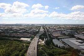 | |
Aerial view looking east in December 2010. The former location of the toll plaza can be seen. | |
| General information | |
| Type | Motorway |
| Length | 50.2 km (31 mi)[1] |
| Opened | 1960s–2019 |
| Route number(s) |
|
| Former route number |
|
| Major junctions | |
| East end | |
| West end | |
| Location(s) | |
| Major suburbs / towns | Penrith, Blacktown, Parramatta |
| Highway system | |
The M4 route number comprises two connected parts:
- The original section completed between 1971 and 1993 is titled M4 Western Motorway, formerly known as F4 Western Freeway.[2][3][4] It spans between Concord in the east, to Glenbrook in west, where it continues as the Great Western Highway as the A32. The section between Church Street in Parramatta to Concord was widened as the first stage of WestConnex, and is tolled as part of WestConnex.[5]
- An eastern 5.5-kilometre (3 mi) tunnel extension of the M4 from Homebush to Haberfield, known as the M4 East or New M4 Tunnels, was completed as the second stage of WestConnex and opened to traffic on 13 July 2019.[6][7][8] This section is also tolled as part of WestConnex.
Approximately 36 kilometres (22 mi) of the motorway-grade road is not tolled, being that section of the road between Merrylands and Glenbrook. The WestConnex section between Parramatta and Haberfield, known as New M4, is tolled as part of WestConnex.[9][5]
Sections
Alignment

The first main road west from Sydney was the Great Western Highway, shown above in orange. The County of Cumberland planning scheme provided for a modified route west, much of which was later built as the M4 Western Motorway. With the opening of the M4 East tunnel in 2019, the M4 extends as far east as Dalhousie Street, Haberfield.
M4 Western Motorway

The M4 Western Motorway was originally constructed in several stages as the F4 Western Freeway between the late 1960s and the mid-1980s. On the basis of a pre-election promise made by the NSW Premier Neville Wran in 1976, all land reserved for the expressway between Pyrmont and the (then) eastern termination point at Strathfield was sold off to property developers or declassified as a freeway corridor in 1977 by the State Government.[10][11] The F4 Western Freeway from Strathfield to Auburn was opened on 16 December 1982 by Premier Wran.[12] However a lack of funding resulted in the Wran Labor government halting plans to construct the final stage between Mays Hill and Prospect in 1985. In December 1989 work to construct this stage began as a Build-Own-Operate-Transfer project.[13] In return for funding construction StateWide Roads, the consortium awarded to build the stage, was given permission to toll the section between James Ruse Drive and Silverwater Road as traffic volumes on this section were significantly higher than between Mays Hill-Prospect and would allow a shorter toll period with lower tolls. The consortium would also widen the section between James Ruse Drive and the newly constructed Homebush Bay Drive to six lanes. The Mays Hill to Prospect section opened in May 1992 and an initial of a $1.50 toll was implemented. The concession held by StateWide Roads ended on 15 February 2010, with operation of the motorway returned to the Roads and Traffic Authority and the toll removed.
The Motorway is mostly three or four lanes wide in either direction, and carries constant heavy traffic during daylight hours, seven days a week. Built as a four-lane motorway, it was widened to six lanes during 1998 to 2000, but this did little to ease the congestion.
Originally planned in the mid-1950s to start in the Sydney central business district,[14] the eastern section was built only as far west as Pyrmont, as part of the North West Expressway, or F3, a freeway that would connect the Sydney and Newcastle central business districts. This section is now part of the Western Distributor. From there it was to have joined with the Western Expressway, the F4, and the Southern Expressway, the F6, in Glebe.[15] At the western end of the Western Freeway as it was known in the late 1960s was to be routed through the Mitchell's Pass area through to Blaxland, however due to protests and the fact that the historic Lennox Bridge was very close to the intended pathway, it was decided to terminate the road at Russell Street, Emu Plains until a solution could be later found. This would have bypassed the Lapstone Hill area and avoided the sharp bends as the road enters Glenbrook. In December 1989 the extension of the freeway from Russell Street, west to the Great Western Highway in the vicinity of Governors Drive would bypass the narrow and winding section of the Great Western Highway, including the historic Knapsack Bridge. In June 1993, the new section of freeway between Emu Plains and Lapstone was opened to traffic.[16]
In 2013, the state government announced the intention to implement a 'Managed Motorway' scheme on the M4 over the coming years to improve traffic flow. Mechanisms to be used include improved Variable Message Signs, Ramp metering signals, dynamic speed and incident management, and an upgrade of the Emergency Telephone System.[17]
The M4 Western Motorway used to be part of the Sydney Metroad 4 until 2013, when the new M4 route designation was proclaimed along the whole motorway.[18]
The section between Church Strreet in Parramatta and the eastern end at Concord was widened as part of stage 1 of WestConnex works. Construction commenced in March 2015. In November 2015, it was announced that toll points would be reinstated on this section from 2017 to cover costs of the WestConnex project (upgrading and M4 East). The toll was introduced on 15 August 2017.[5]
M4 East
 M4 East Tunnel western exit at Homebush | |
| Overview | |
|---|---|
| Route | M4 Motorway |
| Start | Haberfield (east) |
| End | Homebush (west) |
| Operation | |
| Work begun | 2015 |
| Constructed |
|
| Opened | 13 July 2019 |
| Owner | WestConnex |
| Operator | Sydney Motorway Corporation |
| Toll | $4.41 (2020 dollars, subject to indexing, each way) |
| Technical | |
| Length | 5.5 kilometres (3 mi) |
| No. of lanes | 3 in each direction |
| Operating speed | 80 kilometres per hour (50 mph) (variable speed limit) |
Up until 2019, the eastern end of the M4 was at North Strathfield, some 15 kilometres (9.3 mi) from the Sydney central business district. Over the years a number of proposals were made to extend the M4 east towards the city. One plan in the 1990s involved extending the M4 eastwards by approximately 5 kilometres (3.1 mi) so that it would subsequently end in Ashfield and be continuous with the City West Link. Further planned upgrades to the City West Link would mean commuters going west out of the city could get to Parramatta without passing through traffic lights. A subsequent plan outlined a $7 billion plan to link the M4, Victoria Road, City West Link and Sydney Airport using a network of tunnels. Both plans were subsequently shelved, with the NSW Government citing the need for an integrated plan for transport.
In the month prior to the 2011 state election, the NRMA released a report in which it recommended building a tunnel to connect the end of the M4 at Concord and the start of the City West Link, relieving Parramatta Road of enough traffic to convert it into two lanes for slower-moving local traffic, two lanes of light rail and a cycleway.[19] The report argued that this would allow Parramatta Road to be transformed with medium-density housing, shops and cafes and that the $10.04 billion in additional stamp duty and other revenues from this would pay for the $7.38 billion price tag of the project.[20]
In October 2012, the NSW Government announced their commitment to deliver the WestConnex project, involving widening the existing M4 motorway as well as extending it east with a tunnel from North Strathfield to Taverners Hill. The project also involved duplicating the M5 East tunnel and building a new tunnel linking the M4 and M5 motorways.[21]
In June 2015, the tender to design and build the M4 East was awarded to Leighton Contractors, Samsung and John Holland.[22] Located 35 metres (115 ft) beneath Parramatta Road, the 5.5-kilometre (3 mi) dual-tunnel was funded through a $1.8 billion grant from the NSW Government and, from the Australian Government, a $1.5 billion grant and concessional loan of up to $2 billion, plus user tolling.[23] The M4 East opened to traffic on 13 July 2019[7][8] and tolls were levied on both the M4 East Tunnel ($4.41 in 2020,[24] comprising a flagfall and a change per distance travelled, subject to indexing) and the widening of the M4 between Parramatta and Homebush (base of $4.21 each way, subject to indexing). Both tolls will continue until 2060.[25][26]
M4–M5 Link
Stage 3 of the WestConnex scheme will see a new motorway connection running from the end of the M4 at Haberfield to connect with the airport and the M8 Motorway (formerly the New M5) at St Peters, along with an interchange at Rozelle linking to the Anzac and Iron Cove bridges. This section, currently under construction, aims to reduce travel times between Western Sydney and Port Botany while removing heavy vehicles from surface streets in the Inner West. This section is due to open to traffic in 2023.[27][28] It is unknown what the route designation in this section will be.
Toll
The WestConnex section of the M4 between Church Street, Parramatta and Haberfield are tolled by distance travelled as part of the WestConnex. Toll points are located at entrances and exits along this section. The toll charge consists of:
- a flagfall - $1.37 for cars and motorcycles as of 2020
- a charge per kilometre - $0.51 for cars and motorcycles per km as of 2020
As of June 2020, the maximum toll for a continuous car or motorcycle journey along the M4 is $8.20.[29] Tolls for heavy vehicles are triple of cars and motorcycles. Toll rices increase by 4% or the consumer price index (CPI) every year, whichever is greater, until 2040, after which CPI will apply.
A toll point was previously introduced between James Ruse Drive and Silverwater Road in both directions until February 2010.
Exits and interchanges
| LGA | Location | km[1] | mi | Destinations | Notes |
|---|---|---|---|---|---|
| Blue Mountains | Glenbrook | 0 | 0.0 | Road continues as | |
| Blue Mountains line | 0.6 | 0.37 | Railway line runs on an overhead bridge. Bridge name unknown. | ||
| Penrith | Leonay | 1.7 | 1.1 | Offset dumbbell interchange | |
| Nepean River | 2.6 | 1.6 | Regentville Bridge | ||
| Penrith | Jamisontown | 4.0 | 2.5 | Mulgoa Road [north] – Penrith, Richmond Mulgoa Road [south] – Mulgoa, Glenmore Park | Diamond interchange |
| Glenmore Park | 7.5 | 4.7 | Diamond interchange | ||
| Claremont Meadows | 12.7 | 7.9 | Kent Road [north] – Werrington Kent Road [south] – Orchard Hills | Eastbound entrance and westbound exit only; Half-diamond interchange | |
| South Creek | 13.2 | 8.2 | Bridge over the creek. Bridge name unknown. | ||
| Penrith | St Clair | 13.7 | 8.5 | Mamre Road [north] – St Marys, Marsden Park Mamre Road [south] – Erskine Park, Badgerys Creek | Partial cloverleaf interchange |
| Erskine Park | 17.2 | 10.7 | Roper Road [north] – Mt Druitt, Lethbridge Park Erskine Park Road [south] – Erskine Park | Eastbound entrance and westbound exit only; Partial cloverleaf interchange | |
| Blacktown | Eastern Creek | 21.6 | 13.4 | Wallgrove Road [north] – Rooty Hill, Plumpton Wallgrove Road [south] – Eastern Creek, Horsley Park | Light Horse Interchange; no toll applicable |
| Light Horse Interchange – A modified four-level stack interchange; tolled entrance to and exit from the M7 | |||||
| Blacktown | 25.5 | 15.8 | Reservoir Road [north] – Blacktown Reservoir Road [south] – Pemulwuy, Sydney Motorsport Park, Wet'n'Wild, Prospect Reservoir | Partial diamond and partial cloverleaf interchange | |
| Prospect | 27.4 | 17.0 | Prospect Highway [north] – Prospect, Seven Hills, Winston Hills Prospect Highway [south] – Pemulwuy, Wetherill Park, Wet'n'Wild, Prospect Reservoir | Partial offset dumbbell interchange | |
| Parramatta | South Wentworthville | 32.0 | 19.9 | Diamond interchange | |
| Merrylands | 33.7 | 20.9 | Coleman Street [south] – Merrylands | Eastbound entrance ramp from Great Western Highway; Westbound exit via Coleman Street to the north and south | |
| 34.6 | 21.5 | Burnett Street [north] – Parramatta Burnett Street [south] – Merrylands | Eastbound entrance and westbound exit only | ||
| Granville | 36.2 | 22.5 | Western boundary of toll road | ||
Woodville Road [south] – Villawood | Eastbound exit to Great Western Highway / Church Street, north and south; westbound entrance from Woodville Road, south only | ||||
| Clyde | 37.7 | 23.4 | James Ruse Drive [north] – Rose Hill, North Parramatta, Northmead | Eastbound exit to the north only; westbound entrance from the north only | |
| 37.8 | 23.5 | James Ruse Drive [north] – Rose Hill, North Parramatta, Northmead James Ruse Drive [south] to the Great Western Highway | Eastbound entrance and westbound exit only | ||
| Duck River | 38.8 | 24.1 | Bridge over the river. Bridge name unknown. | ||
| Cumberland | Lidcombe | 40.4 | 25.1 | Diamond interchange | |
| Haslams Creek | 41.2 | 25.6 | Bridge over the creek. Bridge name unknown. | ||
| Cumberland | Lidcombe | 41.6 | 25.8 | Hill Road [north] – Wentworth Point, Sydney Olympic Park Hill Road [south] – Lidcombe | Eastbound exit to the north; Eastbound and westbound entrance from the north only |
| Homebush West | 43.3 | 26.9 | Offset diamond interchange | ||
| Strathfield | Homebush | 44.0 | 27.3 | M4 Western Motorway eastern terminus; M4 East western terminus | M4 East Tunnel entrance/exit |
| 45.0 | 28.0 | Westbound entrance only | |||
| Powells Creek | 45.1 | 28.0 | Tunnel under the creek; bridge over the creek. Bridge name unknown. | ||
| Strathfield | North Strathfield | 45.5 | 28.3 | Sydney Street to Concord Road [north] – Concord Sydney Street to Concord Road [south] – North Strathfield, Strathfield Concord Road [north] – Concord | Eastbound exit to the north and south; Westbound entrance from the north only |
| Concord Road [north] – Concord Concord Road [south] – North Strathfield, Strathfield | Tunnel entrance and exit; Eastbound entrance and westbound exit only | ||||
| 45.9 | 28.5 | Westbound entrance and eastbound exit from/to the east only; Termination of above-ground roadway | |||
| Inner West | Haberfield | 49.2 | 30.6 | M4 East Tunnel entrance/exit; Eastern boundary of toll road | |
| Tunnel entrance and exit: M4 East terminus; Westbound entrance and eastbound exit from/to the north only | |||||
| 50.2 | 31.2 | Great Western Highway / Parramatta Road (east) – Sydney, Sydney Airport (via A36) | Tunnel entrance and exit: M4 East terminus; Road continues [east] as Great Western Highway / Parramatta Road Westbound entrance and eastbound exit from/to the east only | ||
1.000 mi = 1.609 km; 1.000 km = 0.621 mi
| |||||
References
- 15–17 Great Western Hwy, Glenbrook NSW 2773 to 150 Parramatta Road, Ashfield NSW 2131 (Map). Google Maps. 2020. Retrieved 28 May 2020.
- Western Motorway (M4) Ozroads: the Australian Roads Website. Retrieved on 29 August 2008.
- Historic Photos, Ozroads: the Australian Roads Website. Retrieved on 29 August 2008.
- M4 Photos Today, Ozroads: the Australian Roads Website. Retrieved on 29 August 2008.
- "M4 Widening | WestConnex". www.westconnex.com.au. Retrieved 18 August 2017.
- Alpha Numeric Implementation Factsheet, Roads and Maritime Services. Retrieved 28 May 2013
- "WestConnex". NSW Government. Archived from the original on 10 July 2019. Retrieved 10 July 2019.
- "New M4 tunnels to open this weekend". WestConnex. 10 July 2019. Retrieved 10 July 2019.
- "New M4 tolls". WestConnex. Retrieved 19 June 2020.
- Lucy, Richard (1979). "Wran's our man: The 1978 NSW state election". Politics. 14 (1): 89–96. doi:10.1080/00323267908401697. Retrieved 5 May 2020.
- Black, John (2006). Bramston, Troy (ed.). Transport. The Wran Era (illustrated ed.). Federation Press. pp. 134–142. ISBN 1862876053.
- Jones, Cathy (31 January 2017). "M4 Motorway History". Strathfield Heritage. Retrieved 5 May 2020.
- "Department of Main Roads Annual Report 1988-89" (PDF). OpenGov NSW. Department of Main Roads. p. 6, 31. Retrieved 20 March 2020.
- Western Motorway (M4) Construction, Ozroads: the Australian Roads Website. Retrieved on 29 August 2008.
- Torr, Bradley. "The M4 Motorway – a history and exit guide". Geocities. Archived from the original on 24 October 2009. Retrieved 29 August 2008.CS1 maint: BOT: original-url status unknown (link)
- "Knapsack Viaduct, Lapstone". New South Wales Heritage Database. Office of Environment and Heritage.
- Benefits, Features and Tools of a Managed Motorway – Roads and Traffic Authority. Retrieved on 24 October 2013.
- "M4 Motorway Website". Statewide Roads. Retrieved 29 August 2008.
- "Boulevard of dreams comes with a hidden cost". The Sydney Morning Herald. 14 February 2011. Retrieved 15 February 2011.
- "New plan to transform Sydney's West" (Press release). NRMA. Retrieved 15 February 2011.
- "WestConnext Green Light" (Press release). WestConnex: Government of New South Wales. 3 October 2012. Archived from the original on 25 October 2013. Retrieved 24 October 2013.
- "Leighton team scoops $2.7bn Sydney motorway". Construction Index. 8 June 2015. Retrieved 4 January 2020.
- "M4 East: Project Overview" (PDF). WestConnex. NSW Government and Australian Government. September 2015. Retrieved 5 May 2020.
- "Toll calculator". Using toll roads. Linkt: Transurban Limited. 2020. Retrieved 5 May 2020.
- "WestConnex M5 Project Deed Schedules" (PDF). Roads & Maritime Services. Government of New South Wales. 2015.
- West, Michael (28 February 2018). "WestConnex: when four tollroads become ten". Michael West Media. Retrieved 5 May 2020.
- Infrastructure New South Wales (2012). "First things first: the state infrastructure strategy 2012–2032" (PDF). Archived from the original (PDF) on 13 August 2015. Retrieved 6 August 2015.
- https://westconnex.com.au/M4-M5LinkTunnels WestConnect M4-M5 Link Tunnels
- "Tolling on WestConnex". WestConnex. Retrieved 24 June 2020.
External links
| Wikimedia Commons has media related to M4 Western Motorway. |
- O'Sullivan, Matt; Saulwick, Jacob (2016). "Sydney 2026: Chapter 1: The future of Sydney roads and rail: The Commute". The Sydney Morning Herald.