Parramatta Road
Parramatta Road is the major historical east-west artery of metropolitan Sydney, New South Wales, Australia, connecting the Sydney CBD with Parramatta. It is the easternmost part of the Great Western Highway. Since the 1980s its role has been augmented by the City West Link Road and Motorway M4.
Parramatta Road | |
|---|---|
 | |

| |
| General information | |
| Type | Road |
| Length | 23 km (14 mi) |
| Opened | 1811 |
| Route number(s) |
|
| Former route number |
|
| Major junctions | |
| East end | |
| |
| West end | |
| Location(s) | |
| Major suburbs | Ultimo, Chippendale, Glebe, Camperdown |
The road begins as a continuation of George Street at Harris St Ultimo and as far as City Road is called Broadway. Its 23 kilometres (14 mi) distance is dominated by caryards and small marginally-viable shops. At the same time, however, it has over 100 abandoned and derelict stores.[1][2] Owing to this and its abrasively noisy traffic, it has rarely been considered beautiful.[3]
Opened in 1811, it is one of Sydney's oldest roads and Australia's first road between two cities (before Sydney and Parramatta coalesced). Today, over 3 million commuters every year drive Parramatta Road.[4] The road is the hub of Sydney's motor dealership industry - with 67% of the adjacent land used for motor retailing and services.
History
1790s–1800s: Development
Parramatta was settled by Europeans in the same year (1788) as Sydney. The Parramatta River was used as navigation between them. Sometime between 1789 and 1791 an overland track was made to provide an official land route between the two settlements.[5]
Parramatta Road dates to the 1792 formation of a route linking Sydney to the settlement of Parramatta. This route was formalised under the direction of Surveyor-General Augustus Alt in 1797. Parramatta Road became one of the colony's most important early roads, and for many years remained one of Sydney's principal thoroughfares.[6] The early road was a poorly built and poorly maintained track through bush. In 1794, the governor of the colony reported that he had caused a very good road to be made, but there is no evidence that any bridges were built over the streams. The road subsequently deteriorated and on 9 June 1805 the Sydney Gazette reported that the road was impassable as the result of heavy rain. Attempts to improve the road continued over the years.[7]
1810–1815
By 1811, Parramatta Road had officially opened to traffic and was financed during a large portion of the 19th century by a toll, with toll booths located at what now is Sydney University and the Duck River. Governor Macquarie called tenders for the repair of the road, raised a 3 shilling per gallon levy on spirits and levied a toll to pay for the work. The road was to be 10 metres wide. This turnpike road was opened on 10 April 1811. The toll barriers were at the present Railway Square and at Becket's Creek (near Parramatta).
In 1814, a stage cart service was established along Parramatta Road. Fares were 10 shillings for passengers and 3 pence for letters. Heavy rain again nearly destroyed this road, so in 1817 it was announced that all tree-stumps would be removed and the road paved with stone which would be covered with earth and gravel. This improvement was announced as finished on 15 January 1815.
In 1815 the "profit" from the Sydney toll reached £465. The growth of Sydney caused the toll barrier to be moved to Grose Farm (present University of Sydney) in April 1836. In 1839 it was moved further west to Annandale.
1820s–1880s

The colony's first stage coach (valued at £300) was imported in 1821 but did not begin regular service until 1823. The stage left the city at 7:00 am, arrived in Parramatta at 9:30 am and left Parramatta for the return journey at 4:00 pm. Inside passengers were charged 6 shillings. Hazards on the road included the threat of attacks by Indigenous people and bushrangers. Hotels and settlements sprang up along the road to serve coaching traffic.[8]
The importance of the road declined with the advent of the Sydney-Parramatta railway in 1855. In 1883, a steam tram line opened along Parramatta Road as far as Annandale, and was extended onward to Norton St in 1884, where it turned to run along Norton Street to Short Street.
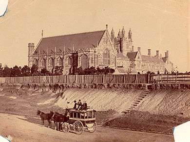
In the 1800s, the Government acquired a strip of land from Ashfield to Burwood from the Rosebank Estate, owned by the Sisters of the Good Samaritan, Australia's first religious congregation. Rosebank College now stands on the former Rosebank Estate, and the heritage-listed building of the private school stands adjacent to the road at Five Dock.
1900s–present: Motorisation
Sydney Municipal Council began widening the major routes into the city centre in 1911, including the construction of Broadway and the widening of the cutting on Parramatta Road adjacent to Sydney University. In the 1920s, the road was sealed and tramlines were removed from the road. Sheep and cattle were still crossing Parramatta Road at Homebush as late as the 1960s.
In 2012 it was announced that the road would be widened and lowered below street level in a "slot" as part of the Roads and Maritime Services WestConnex motorway proposal. The WestConnex proposal was later changed to a pair of tunnels parallel to Parramatta Road known as M4 East, running between North Strathfield and Haberfield. The new tunnels opened to traffic in July 2019.[9][10] The tunnel entry and exit to Parramatta Road are located south-east of the Wattle Street and Parramatta Road intersection.
Urban blight
The road has been criticised by the community for its traffic pollution, congestion, and for its vacant shops and rundown buildings, particularly between Leichhardt and Concord, and local government has been accused of failing to adopt policies to encourage the redevelopment and regeneration of vacant sites.[11]
A local mayor described it as a "varicose vein".[12] A NSW Business Chamber Executive Patricia Forsythe said that the road is "one of the least attractive commercial areas of Sydney". Former NSW premier Nick Greiner thought the road looked "like Beirut on a bad day". The Sydney Morning Herald writer Elizabeth Farrelly dismissed it as a "filthy hole".[13] On a lighter note, Tess De Quincey, an Australian performer/director said, "Every chapter of Sydney's history has been written on Parramatta Road."[14] A Sydney Morning Herald editor said that whilst the road is "ugly in parts, drab in others, and generally unpleasant", it is still "fundamental to the economic and social viability of the greater city".[15]
Since the 1970s many buildings fronting Parramatta Road, especially those in the prime locations of the Inner West (from Homebush to Newtown), have become vacant and fallen into disrepair, with many vandalised. Previously these buildings were a major part of local life for the suburbs along Parramatta Road, providing employment, retailing and other services. The buildings with graffiti and broken windows provide a sight that is sought out by graffiti artists and proficient urban photographers.[16]
Nicholas Munning, an owner of a music store in Annandale, described the road as, "A lost cause...You can see the hodgepodge of buildings - abandoned buildings, abandoned shops - [with people thinking] let’s just let this sit here for four years until we get council approval to knock it down and build apartments...They don’t care if it sits there vacant with broken windows...The problem is the whole road looks like that. So nobody is going to say, 'hey, this is a great area. I’m going to spend $x making a really classy looking shop or restaurant'.”[17]
Furthermore, the NSW Government has proposed to allow up to 35,000 homes along the road by 2035. However, revitalisation is worth millions of dollars to developers, with such plans also being met with roadblocks from local governments, thus leading to prolonged court disputes as the buildings continue to decay.[17]
Location

The highway forms the boundaries of various suburbs along the way and ends at the junction of Church Street, Parramatta, where the Great Western Highway briefly turns to the north. Parramatta Road forms the southern boundary of the following suburbs:
Parramatta Road forms the northern boundary of the following suburbs:
West of Concord and Burwood, Parramatta Road passes through Strathfield, Homebush, Auburn and Granville before reaching Parramatta.
References
- "City's main artery a desolate wasteland". The Daily Telegraph, Mason McCann. 18 April 2011. Retrieved 14 January 2015.
- "AV Union". Time Out Sydney, Nicholas Adams. 16 October 2012. Archived from the original on 15 January 2015. Retrieved 14 January 2015.
- "Renew project targets Forum". Alt Media, Mason McCann. 26 September 2013. Retrieved 14 January 2015.
- http://www.parramattaroad.com/html/history.html
- Broomham, Rosemary (2001), Vital connections: a history of NSW roads from 1788, Hale & Iremonger in association with the Roads and Traffic Authority NSW, p. 25, ISBN 978-0-86806-703-2
- "Sandstone Kerb - Parramatta Road". State Heritage Register. Office of Environment and Heritage, Government of New South Wales. 2005. Retrieved 7 October 2013.
- Francis Peron, 'Account of Port Jackson and Sydney Town, New South Wales', translation quoted in The literary panorama, vol 10, Charles Taylor, London, 1809, col 921
- The Roadmakers: A History of Main Roads in New South Wales, Department of Main Roads, Sydney, 1976, p 47
- "WestConnex". NSW Government. Archived from the original on 10 July 2019. Retrieved 10 July 2019.
- "New M4 tunnels to open this weekend". WestConnex. 10 July 2019. Retrieved 10 July 2019.
- "CAN PARRAMATTA RD ROCK ONCE MORE?". Ciao Magazine. 12 July 2013. Retrieved 14 January 2015.
- "200-year dream for renewal and free flow for 'varicose vein'". Sydney Morning Herald. 5 October 2012. Retrieved 16 January 2015.
- "Developers won't save Parramatta Road alone". Elizabeth Farrelly, Sydney Morning Herald. 21 June 2012. Retrieved 16 January 2015.
- https://books.google.com.au/books?isbn=9052010366
- "A chance to get Parramatta Road right". Sydney Morning Herald. 31 October 2014. Retrieved 16 January 2015.
- Why derelict buildings worth millions are being left behind in a region desperate for places to live by David Barwell (The Daily Telegraph)
- 'The shops have closed': Parramatta Road 'a lost cause', retailer says by Garry Maddox (Sydney Morning Herald)