General Holmes Drive
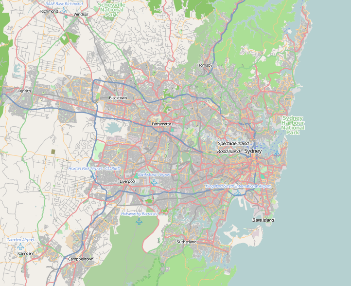
General Holmes Drive is a 5-kilometre (3.1 mi) major divided road located in Sydney, New South Wales, Australia. The road forms part of the M1, the A1, the Sydney Orbital Network, and the Australian Highway 1 network. Initially built in 1919 as a two-lane road and duplicated in 1951, the road partially circumnavigates Sydney Airport with its north-eastern terminus in Mascot, heading west and then south and then south-west, with its south-western terminus with The Grand Parade in Brighton-Le-Sands.[1]
General Holmes Drive | |
|---|---|
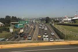 | |
General Holmes Drive, looking south-west from the Sydney Airport overpass | |
 NE end SW end | |
| Coordinates |
|
| General information | |
| Type | Motorway |
| Length | 5 km (3.1 mi) |
| Route number(s) |
|
| Former route number |
|
| Major junctions | |
| NE end | Joyce Drive Mascot, Sydney |
| SW end | Brighton-Le-Sands, Sydney |
| Location(s) | |
| Major suburbs / towns | Sydney Airport |
| Highway system | |
The road forms major links with the Southern Cross Drive and the M5 East, both part of the Sydney Orbital Network.
The road is named in honour of William Holmes, a distinguished Australian general who died in action during World War I.
Route
General Holmes Drive starts from Joyce Drive in Mascot, and heads south, reaching a major intersection with Wentworth Drive that carries all traffic exiting from the domestic terminals at Sydney Airport.[2][3] Further west in Botany, the road meets the Mill Pond Road, a short road that connects with the Southern Cross Drive, carrying traffic north towards the Sydney central business district, with the south-westbound route providing access to both the international and the domestic terminals at Sydney Airport.
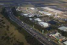
Via an interchange, General Holmes Drive heads south, forming a junction with Foreshore Drive that carries traffic to Port Botany and La Perouse. General Holmes Drive then heads through the Sydney Airport Tunnel, an eight-lane tidal flow culvert under the south-eastern runways of Sydney Airport. As the road exits the tunnel, there is a major exit to the M5. The road crosses over the Cooks River via the Endeavour Bridge, continues southeast into the suburbs of Kyeemagh and Brighton-Le-Sands, before terminating at the junction with The Grand Parade that carries traffic towards Sutherland and Wollongong.[1]
Traffic runs in three lanes in both directions through Kyeemagh, becoming four lanes after the M5 East junction. The M5 East can only be accessed southbound, and traffic joins General Holmes Drive northbound.
Several major billboards are situated towards the northeastern terminus of the General Holmes Drive.[4]
Until July 2019, General Holmes Drive continued for a further 100 metres (330 ft) to the north-east to an intersection with Botany Road crossing the Metropolitan Goods railway line via a level crossing. This section closed when the level crossing was replaced by an underpass at Wentworth Avenue.[5][6][7]
Exits and interchanges
| LGA | Location | km[8] | mi | Destinations | Notes |
|---|---|---|---|---|---|
| Bayside | Mascot | 0 | 0.0 | Joyce Drive north / Ross Smith Avenue west – Sydney Airport | Traffic light intersection |
| Botany | 0.5 | 0.31 | Mill Pond Drive – Botany, Maroubra, Sydney CBD | Traffic light intersection | |
| 0.8 | 0.50 | To Foreshore Road – Port Botany | Southbound exit only | ||
| 1.0 | 0.62 | Northbound exit and southbound entrance at partial Y interchange; Route transition: no route number north, M1 continues south from Southern Cross Drive | |||
| 1.4 | 0.87 | Foreshore Road – Port Botany, La Perouse | North-eastbound exit and entrance | ||
| 2.0 | 1.2 | Foreshore Road – no exit | Westbound entrance only | ||
| Sydney Airport | 2.2– 2.8 | 1.4– 1.7 | Airport Tunnel | ||
| 2.9 | 1.8 | Westbound exit and eastbound entrance at partial Y interchange; Route transition: M1 eastbound, A1 south-westbound | |||
| Kyeemagh | 4.1 | 2.5 | Bestic Street – Rockdale | Traffic light intersection | |
| Ramsgate Beach | 4.9 | 3.0 | South-Western terminus: continues south as The Grand Parade | ||
| |||||
See also
- Freeways in Australia
- Freeways in Sydney
References
- "Southern Cross Drive and General Holmes Drive". Ozroads. Retrieved 21 October 2016.
- "WestConnex Enabling Works: Airport East Precinct" (PDF) (Map). Roads & Maritime Services. Government of New South Wales. 2015. Retrieved 21 October 2016.
- "Projects: Sydney South: Airport East Precinct". Roads & Maritime Services. Government of New South Wales. 11 August 2016. Retrieved 21 October 2016.
- "M1 – General Holmes Drive". Digital Billboards. APN Outdoor. 2016. Retrieved 21 October 2016.
- John Holland To Deliver Airport East Project John Holland 30 November 2017
- New underpass to keep airport traffic flowing Roads & Maritime Services 1 July 2019
- SAFE Notice 2019 Number: 2-4387 Australian Rail Track Corporation
- Google (22 June 2015). "General Holmes Drive" (Map). Google Maps. Google. Retrieved 22 June 2015.
External links