Epping, New South Wales
Epping is a suburb of Sydney, in the Australian state of New South Wales, 18 kilometres north-west of the Sydney central business district in the local government area of the City of Parramatta. Epping is located in the Northern Sydney region,[2] and is sometimes simply referred to as the “North-West” or North Shore. The suburb is the most north-eastern area of the City of Parramatta. North Epping is a separate suburb to the north and under a different council, Hornsby Shire.
| Epping Sydney, New South Wales | |||||||||||||||
|---|---|---|---|---|---|---|---|---|---|---|---|---|---|---|---|
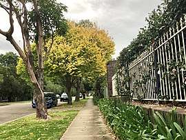 Suburban street in Epping | |||||||||||||||
| Population | 23,688 (2016 census)[1] | ||||||||||||||
| • Density | 3,463.2/km2 (8,970/sq mi) | ||||||||||||||
| Established | 1899 | ||||||||||||||
| Postcode(s) | 2121 | ||||||||||||||
| Area | 6.84 km2 (2.6 sq mi) | ||||||||||||||
| Location | 18 km (11 mi) north-west of Sydney CBD | ||||||||||||||
| LGA(s) | City of Parramatta | ||||||||||||||
| Region | |||||||||||||||
| Federal Division(s) | Bennelong | ||||||||||||||
| |||||||||||||||
History
The Wallumedegal Aboriginal tribe lived in the area between the Lane Cove River and Parramatta River.[3] In 1792, Governor Arthur Phillip began the granting of parcels of lands to marines, and the area was referred to on Phillip's maps as the Field of Mars, Mars being the Roman god of war. It contained the area of what is now Epping, along with the surrounding suburbs of Ryde and Marsfield.
Epping railway station was opened on 17 September 1886, originally named "Field of Mars", and quickly renamed to "Carlingford" on 5 April 1887.[4] The Post Office was opened on 16 October 1889, originally named "East Carlingford".
In 1899 the suburb name of Epping was adopted following the suggestion by a local landowner William Midson (1849–1924), after a town near Epping Forest in Essex, where his father was born.[5] At this time, the names of the post office and the railway station were both changed to Epping.[6][7]
The Seven Network had its headquaters and television production studios in Epping until 2009. The site is now occupied by residential apartments.
Until 2016, parts of Epping were under three different councils: Hornsby Shire, City of Ryde and City of Parramatta. A 2015 review of local government boundaries recommended that all of Epping be amalgamated into the City of Parramatta, and this became effective on 12 May 2016.[8][9]
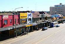
Commercial area
Epping features a large Coles supermarket on Rawson Street, and many small businesses including newsagencies, pharmacies, Asian grocers and many restaurants near Epping railway station. Other commercial and light industrial developments are also located in the surrounding area.
The Epping RSL Club is a popular venue, which attracts many people including students from the nearby Macquarie University. Epping also has a pub (the Epping Hotel) with its own nightclub, Tracks.
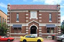
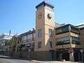 The Epping Club
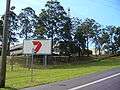 Former Seven Network television studios, now demolished
 Epping Railway Station
Redevelopment as "Urban Renewal Area"
A major re-development of the Epping Town Centre is planned as part of the NSW government's "Urban Renewal Area" programme (originally called the "Urban Activation Precincts" programme). The changes to zoning for this programme cover 54 hectares, including provision for building heights of 8 to 22 storeys for mixed commercial and residential use within a 400-metre radius of the railway station, and about 3,750 additional homes within 800 metres of it.[10] These zoning changes were finalized and approved in March 2014, although residents have expressed concerns about issues including traffic management, lack of parking, storm water drainage and access to schools.[11]
The first major project under this programme was scheduled to be Grocon's amalgamation of four lots at 30-42 Oxford Street, acquired in September 2015 for a cost of $56 million. Plans for a 16-storey development of more than 250 apartments for a total value of more than $300 million were lodged with the council. However, in early 2016 they sold the blocks.[12][13] In late 2019, the "Oxford Central" development of 251 or 252 apartments, car parking and retail was completed on the site by developer Greaton and construction company Ceerose.[14][15]
Transport
Epping railway station is a junction station on the Northern Line of the Sydney Trains network, the Central Coast & Newcastle Line of the NSW TrainLink network, and the new rapid transit Sydney Metro Northwest since its opening on 26 May 2019.[16]
Epping is also well-serviced by bus facilities by State Transit and Hillsbus. The M2 Hills Motorway runs along the northern border to the Sydney CBD. Epping Road is a major arterial road in the area that runs east from the railway station to the Pacific Highway.
In spite of the range of public transport options, the 2011 census found that only 31% of employed people travelled to work on public transport, compared to 51% who travelled by car (either as driver or as passenger).
Community facilities
Epping is well served with community facilities, provided by the councils or other organizations. These include:
- Epping Aquatic and Leisure Centre (also known as Dence Park Aquatic Centre) off 26 Stanley Road, features a heated 26 °C (79 °F) outdoor 50-metre pool, a warmer heated 31 °C (88 °F) "learn to swim" pool, a covered toddlers' play pool, a gymnasium and a kiosk/coffee shop. A range of classes and training is held at the centre.[17]
- Epping Branch Library, at 1 Chambers Court (off Pembroke Street) is a branch of City of Parramatta Library[18] and formerly a branch of Hornsby Shire Library.[19] Membership is free and provides access to a wide range of services.
- West Epping Community Centre is on the corner of Dent and Downing Streets, beside West Epping Park and Oval. Capacity: 100 people. Attached to the Community Centre is the West Epping Community Preschool which shares the two enclosed playgrounds.[20]
- Epping Community Centre[21] at 9 Oxford Street, near the railway station. Capacity: 300 people (all areas combined). Formerly known as the Epping School of Arts, the community centre was designed by Lord Livingstone Ramsay, an architect who was President of Hornsby Shire from 1909 until 1913. It was built in three stages between 1906 and 1916, and officially opened in 1909.[22][23] The building has a large auditorium with a stage, two meeting rooms, a commercial standard kitchen, and a second smaller hall downstairs.[24]
- Epping Leisure and Learning Centre at 1 Chambers Court (off Pembroke Street), downstairs from the Epping Branch Library. Capacity: 100 people.[25]
- Epping Creative Centre at 26 Stanley Road, beside the entrance to Dence Park Aquatic Centre. Capacity: 100 people. This centre has an emphasis on creative and educational leisure activities. Epping Creative Centre was opened in September 1989, originally in the back rooms of the Dence Park building, then in 1999 the council granted full use of the premises.[26]
- Epping YMCA at 15 Ward Street caters for the diverse ages, interests and abilities of the surrounding community. In 2012, a million-dollar redevelopment saw the family centre substantially modernised. Facilities include a health club, group fitness studio, one-court indoor stadium, community program room, international standard gymnastics arena, and tennis courts.[27]
Some schools and churches also have halls and other facilities that can be made available for community uses.
Parks, playgrounds, sports fields
| Name | Address | Facilities |
|---|---|---|
| Boronia Park[28] | 37 Bridge St, Epping | Sporting field, cricket pitch, children's playground (shaded) with 6m climbing web, war memorial, children's bike track, seating, picnic shelters, barbecue, public toilets, change rooms |
| David Scott Reserve[29] | 97 Midson Rd, Epping | Tennis courts, children's playground, seating, picnic tables |
| Duncan Park[30] | 47 Kent St, Epping | Sporting field, croquet green |
| Epping Athletic Track[31] | Norfolk Road, Epping | Athletics track, toilets, car park |
| Epping Oval[32] | Norfolk Road, Epping | Cricket pitch, practice nets, soccer field, toilets, car park |
| Epping Oval Playground[33] | Norfolk Road, North Epping | Fenced playground unit, swings, 6m climbing tower, large double picnic shelter, open grassed area, BBQ, toilets |
| Forest Park[34] | Forest Grove, Epping | Rose garden, war memorial, playground, picnic tables, toilets |
| Grant Close Netball Courts[35] | Grant Close, Epping | Netball courts, toilets |
| Henry Brigg Park (known as Maida Park until 2017[36]) | Maida Road corner of Essex Street, Epping | Swing set, fenced |
| Kim Rutherford Reserve[37] | 20 Wyralla Ave, Epping | Children's playground, seating |
| Loftus Square[38] | 35 Willoughby St, Epping | Two children's playgrounds (junior & senior), seating, multipurpose courts, picnic facilities |
| North Epping Oval[39] | Boundary Road, North Epping | Cricket pitch, soccer field, toilets, car park |
| Pembroke Street Park[40] | 8 Pembroke Street corner of Chambers Court, Epping | Playground, fenced, picnic table |
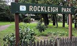
| Rockleigh Park | Essex St, Epping | Small covered pergola |
| Ron Payne Park[41] | Woods St, North Epping | Cricket pitch, practice nets, soccer field, toilets, car park |
| Somerville Oval[42] | Blaxland Road, Epping | Cricket pitch, practice nets, rugby field, toilets, car park |
| West Epping Oval[43] | Downing street, Epping | Cricket pitch, practice nets, soccer field, toilets, car park |
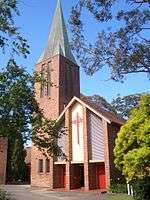
Churches
- All Saints Anglican Church a contemporary Anglican Church in North Epping
- Chester Street Uniting Church (incorporates Oxford Street Uniting Church)
- Chinese Lutheran Church
- Epping Baptist Church
- Epping Church of Christ
- Epping Gospel Chapel
- Epping Presbyterian Church
- Epping Seventh-day Adventist Church
- Life Way Church (a Lutheran Church, known as St. Mark's until March 2014[44])
- North Side Chinese Alliance Church
- Northern Districts Chinese Christian Church
- Our Lady Help of Christians (Roman Catholic) Church
- Presbyterian Reformed Church Epping
- St. Alban's (Anglican), St. Aidan's – West Epping (Anglican) – part of the Epping Parish
- West Epping Uniting Church
Schools
- Arden Anglican School (formerly the Catholic girls' school Our Lady of Mercy College)
- Epping Boys High School (located in Marsfield)
- Epping Heights Public School
- Epping North Public School
- Epping Public School
- Epping West Public School [45]
- Our Lady Help of Christians Catholic Primary School
Formerly the American International School of Sydney was located here.[46]
Demographics
According to the Australian Bureau of Statistics' 2016 Census, Epping had a population of 23,688, of whom 11,697 (49.4%) were male and 11,992 (50.6%) were female.
- Ethnic diversity
- 41.4% of people were born in Australia. The most common countries of birth were China 18.9%, South Korea 7.4%, India 6.0%, Hong Kong 5.4% and Malaysia 1.8%. 38.5% of people only spoke English at home. Other languages spoken at home included Mandarin 20.6%, Cantonese 12.0%, Korean 9.1%, Hindi 2.6% and Tamil 1.4%.
- Age distribution
- The median age of people in Epping was 36 years (national median is 38). Children aged under 15 years made up 17% of the population (18.7% nationally) and people aged 65 years and over made up 13.2% of the population (15.8% nationally).[1]
- Income
- Median weekly household income was $1,973, compared to the national average of $1,438.[1]
- Housing
- More than three quarters (78.5%) of private dwellings were family households, 15.6% were single person households and 5.9% were group households. Stand-alone houses accounted for 55.5% of occupied dwellings, while 32.2% were flats, units or apartments and 12.0% were semi-detached. The average household size was 2.9 people.[1]
- Religion
- The most commonly reported religious affiliations in the 2016 Census were No Religion 36.1%, Catholic 15.1% and Anglican 8.4%. In the fifteen years from 2001 to 2016, the Census shows that the largest change in religion was the number of people who were not affiliated with any religion, which increased from 16.6% to 36.1% of the population.[1][47]
Government
At a local government level, Epping lies solely within the City of Parramatta Local Government Area.[48]
At a state level, Epping is mostly represented by the electoral district of Epping, with a small area on the southern edge of Chesterfield Road that is within the Electoral district of Ryde.
At a federal level, Epping falls in the Division of Bennelong.
References
- Australian Bureau of Statistics (27 June 2017). "Epping (NSW)". 2016 Census QuickStats. Retrieved 3 September 2017.

- https://www1.health.gov.au/internet/main/publishing.nsf/Content/PHN-Northern_Sydney
- Smith, Keith Vincent (2005). Wallumedegal : an Aboriginal history of Ryde. North Ryde, N.S.W.: Community Services Unit, City of Ryde. ISBN 9780959941999.
- "Epping Station". www.nswrail.net. Retrieved 29 September 2016.
- Compiled by Frances Pollon, ed. (1990). The Book of Sydney Suburbs. Angus & Robertson Publishers, Published in Australia. p. 100. ISBN 0-207-14495-8.
- Premier Postal History. "Post Office List". Retrieved 1 June 2012.
- Jervis, James (1961). The Cradle City of Australia: A History of Parramatta, 1788-1961. Parramatta, NSW, Australia: Council of the City of Parramatta. p. 211.
- Walters, Rosaline (18 December 2015). "Parramatta Council scoops up Epping and Carlingford". Northern District Times. Retrieved 5 April 2017.
- Stevens, Kylie (12 May 2016). "Council mergers announced". Parramatta Sun. Retrieved 5 April 2017.
- "Epping Town Centre". Department of Planning & Environment, State Government of New South Wales. Archived from the original on 1 February 2016. Retrieved 9 December 2015.
- Bastians, Kate (2 April 2014). "High hopes were dashed". Northern District Times.
- Hutchinson, Samantha (17 September 2015). "Grocon ramps up with $56 million office block site in Epping, Sydney". The Australian. Retrieved 9 December 2015.
- Chancellor, Jonathan (8 February 2016). "Grocon sells Epping site to Chinese developer, Zhengtang". www.propertyobserver.com.au. Retrieved 16 December 2016.
- "Sydney Oxford Central development reaches completion". The Asean Developer. 22 November 2019.
- "Oxford Central". Ceerose. Retrieved 21 February 2020.
- "North-West Rail Link". Transport NSW. Retrieved 3 April 2014.
- "Epping Aquatic and Leisure Centre web site". hornsby.nsw.gov.au. Retrieved 15 April 2014.
- "Epping Library Transferring to Parramatta Council". Hornsby Shire Council. 11 October 2016.
- "Hornsby Shire Library & Information Service". Hornsby Shire Council. Retrieved 13 June 2014.
- "West Epping Community Centre web site". hornsby.nsw.gov.au. Archived from the original on 16 April 2014. Retrieved 15 April 2014.
- "Epping Community Centre web site". hornsby.nsw.gov.au. Archived from the original on 23 June 2014. Retrieved 15 April 2014.
- "Epping". The Cumberland Argus and Fruitgrowers' Advocate. Parramatta, NSW. 24 February 1906. p. 10. Retrieved 25 September 2012 – via National Library of Australia.
- "EPPING". The Cumberland Argus and Fruitgrowers' Advocate. Parramatta, NSW. 5 August 1916. p. 8. Retrieved 25 September 2012 – via National Library of Australia.
- Epping Community Centre Archived 6 June 2013 at the Wayback Machine. Retrieved 25 September 2012.
- "Epping Leisure and Learning Centre". hornsby.nsw.gov.au. Archived from the original on 16 April 2014. Retrieved 15 April 2014.
- "Epping Creative Centre". hornsby.nsw.gov.au. Archived from the original on 16 April 2014. Retrieved 15 April 2014.
- "Epping YMCA". Retrieved 15 April 2014.
- "Boronia Park". Archived from the original on 22 June 2014. Retrieved 13 April 2014.
- "David Scott Reserve". Archived from the original on 22 June 2014. Retrieved 13 April 2014.
- "Duncan Park". Archived from the original on 22 June 2014. Retrieved 13 April 2014.
- "Epping Athletic Track". Retrieved 13 April 2014.
- "Epping Oval". Retrieved 13 April 2014.
- "Epping Oval Playground". Retrieved 13 April 2014.
- "Forest Park". Retrieved 13 April 2014.
- "Grant Close Netball Courts". Retrieved 13 April 2014.
- Narelle Underwood – Chair, Geographical Names Board (11 August 2017). "GEOGRAPHICAL NAMES ACT 1966". NSW Government Gazette (87).
- "Kim Rutherford Reserve". Archived from the original on 22 June 2014. Retrieved 13 April 2014.
- "Loftus Square". Archived from the original on 22 June 2014. Retrieved 13 April 2014.
- "North Epping Oval". Retrieved 13 April 2014.
- "Pembroke Street Park". Retrieved 13 April 2014.
- "Ron Payne Park". Retrieved 13 April 2014.
- "Somerville Oval". Retrieved 13 April 2014.
- "West Epping Oval". Retrieved 13 April 2014.
- "Life Way the new name for Epping Lutheran Church". Community News, published by Greg Smith SC MP, member for Epping. April 2014.
- https://eppingwest-p.schools.nsw.gov.au/
- "Contact Us" American International School of Sydney. 1 April 2001. Retrieved on 15 September 2015.
- Australian Bureau of Statistics (9 March 2006). "Epping (State Suburb) 2001". 2001 Census QuickStats. Retrieved 8 April 2014.
- "City of Parramatta Council: The merger of Parramatta City, The Hills Shire, Auburn City, Holroyd City and Hornsby Shire councils". New South Wales Government. 2016.
External links
| Wikimedia Commons has media related to Epping, New South Wales. |
- Joan Rowland (2008). "Epping". Dictionary of Sydney. Retrieved 27 September 2015. [CC-By-SA]