County Cork
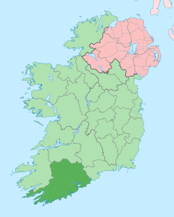
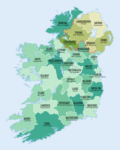
County Cork (Irish: Contae Chorcaí) is a county in Ireland. It is the largest and southernmost county of Ireland, situated in the province of Munster and named after the city of Cork, Ireland's second-largest city. The Cork County Council is the local authority for the county. Its largest market towns are Mallow, Macroom, Midleton, and Skibbereen. In 2016, the county's population was 542,868, making it the third-most populous county in Ireland.[3][4] Notable Corkonians include Michael Collins, Jack Lynch, and Sonia O'Sullivan.
County Cork Contae Chorcaí | |
|---|---|
 Coat of arms | |
| Nickname(s): The Rebel County | |
 | |
| Country | Ireland |
| Province | Munster |
| Dáil Éireann | Cork East Cork North-Central Cork North-West Cork South-Central Cork South-West |
| EU Parliament | South |
| Established | 1606[1] |
| County town | Cork |
| Government | |
| • Type | County Council |
| Area | |
| • Total | 7,500 km2 (2,900 sq mi) |
| Area rank | 1st |
| Highest elevation (Knockboy) | 706 m (2,316 ft) |
| Population | |
| • Total | 542,868 |
| • Rank | 3rd |
| • Density | 72/km2 (190/sq mi) |
| Demonym(s) | Corkonian |
| Time zone | UTC±0 (WET) |
| • Summer (DST) | UTC+1 (IST) |
| Eircode routing keys | P12, P14, P17, P24, P25, P31, P32, P36, P43, P47, P51, P56, P61, P67, P72, P75, P81, P85, T12, T23, T34, T45, T56 (primarily) |
| Telephone area codes | 02x, 063 (primarily) |
| Vehicle index mark code | C |
| Website | www |
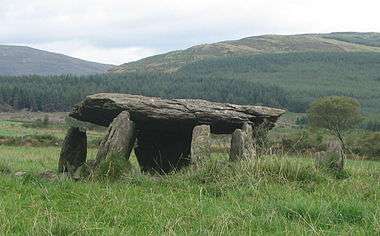
Cork borders four other counties: Kerry to the west, Limerick to the north, Tipperary to the north-east and Waterford to the east. The county contains a section of the Golden Vale pastureland that stretches from Kanturk in the north to Allihies in the south. The south-west region, including West Cork, is one of Ireland's main tourist destinations,[5] known for its rugged coast and megalithic monuments and as the starting point for the Wild Atlantic Way.
The county is known as the "Rebel county", a name given to them by King Henry VII of England for its support of a man claiming to be Richard, Duke of York in a futile attempt at a rebellion.[6] The main third-level educator is University College Cork, founded in 1845, and with a current undergraduate population around 15,000. Significant local industry and employers include technology company Dell EMC, the European headquarters of Apple, and Dairygold, which own milk-processing factories in Mitchelstown and Mallow.
Political subdivisions
Two local authorities have remits which collectively encompass the geographic area of the county and city of Cork. The county, excluding Cork city, is administered by Cork County Council, while the city is administered separately by Cork City Council. Both city and county are part of the South-West Region. For standardized European statistical purposes, both Cork County Council and Cork City Council rank equally as first-level local administrative units of the NUTS 3 South-West Region. Thirty-four such LAU 1 entities are in the Republic of Ireland.
For elections to Dáil Éireann, the county is divided into five constituencies—Cork East, Cork North-Central, Cork North-West, Cork South-Central and Cork South-West. Together they return 18 deputies (TDs) to the Dáil. The county is part of the South constituency for the purposes of European elections.
For purposes other than local government, such as the formation of sporting teams, the term "County Cork" is often taken to include both city and county.
Geography
County Cork is located in the province of Munster, bordering Kerry to the west, Limerick to the north, Tipperary to the north-east and Waterford to the east. It is the largest county in Ireland by land area, and the largest of Munster's six counties by population and area. At the last census in 2016, Cork city stood at 125,657.[3] The population of the entire county is 542,868[3][4] making it the state's second-most populous county and the third-most populous county on the island of Ireland. The remit of Cork County Council includes some suburbs of the city not within the area of Cork City Council.
Baronies
Twenty-four historic baronies are in the county—the most of any county in Ireland. While baronies continue to be officially defined units, they are no longer used for many administrative purposes. Their official status is illustrated by Placenames Orders made since 2003, where official Irish names of baronies are listed.
Civil parishes and townlands
The county has 253 civil parishes.[7] Townlands are the smallest officially defined geographical divisions in Ireland, with about 5447 townlands in the county.
Mountains and upland habitats
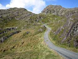
The county's mountain rose during a period mountain formation some 374-360 million years ago and include the Slieve Miskish and Caha Mountains on the Beara Peninsula, the Ballyhoura Mountains on the border with Limerick and the Shehy Mountains which contain Knockboy (706 m), the highest point in Cork. The Shehy Mountains are on the border with Kerry and may be accessed from the area known as Priests Leap, near the village of Coomhola. The upland areas of the Ballyhoura, Boggeragh, Derrynasaggart, and Mullaghareirk Mountain ranges add to the range of habitats found in the county. Important habitats in the uplands include blanket bog, heath, glacial lakes, and upland grasslands. Cork has the 13th-highest county peak in Ireland.
Rivers and lakes
_-_geograph.org.uk_-_263779.jpg)
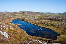
Three rivers, the Bandon, Blackwater, and Lee, and their valleys dominate central Cork. Habitats of the valleys and floodplains include woodlands, marshes, fens, and species-rich limestone grasslands. The River Bandon flows through several towns, including Dunmanway to the west of the town of Bandon before draining into Kinsale Harbour on the south coast. Cork's sea loughs include Lough Hyne and Lough Mahon, and the county also has many small lakes. An area has formed where the River Lee breaks into a network of channels weaving through a series of wooded islands. About 85 hectares of swamp are around Cork's wooded area. The Environmental Protection Agency carried out a survey of surface waters in County Cork between 1995 and 1997, which identified 125 rivers and 32 lakes covered by the regulations.
Coastline
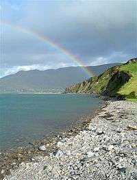
Cork has a mountainous and flat landscape with many beaches and sea cliffs along its coast. The southwest of Ireland is known for its peninsulas and some in Cork include the Beara Peninsula, Sheep's Head, Mizen Head, and Brow Head. Brow Head is the most southerly point of mainland Ireland. There are many islands off the coast of the county, in particular, off West Cork. Carbery's Hundred Isles are the islands around Long Island Bay and Roaringwater Bay.
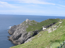
Fastnet Rock lies in the Atlantic Ocean 11.3 km south of mainland Ireland, making it the most southerly point of Ireland. Many notable islands lie off Cork, including Bere, Great, Sherkin, and Cape Clear. Cork has 1,094 km of coastline, the second-longest coastline of any county after Mayo, which has 1,168 km.
Land and forestry
Like many parts of Munster, Cork has fertile agricultural land and many bog and peatlands. Cork has around 74,000 hectares of peatlands, which amount to 9.8% of the county's total land area. And the county contains around 79,188 ha (195,680 acres) of forest and woodland area, or 10.5% of Cork's land area, higher than the national average of 9%.
Wildlife
The hooded crow, Corvus cornix is a common bird, particularly in areas nearer the coast. Due to this bird's ability to (rarely) prey upon small lambs, the gun clubs of Cork County have killed many of these birds in modern times.[8] A collection of the marine algae was housed in the herbarium of the botany department of the University College Cork.[9] Parts of the South West coastline are hotspots for sightings of rare birds, with Cape Clear being a prime location for bird watching.[10][11] The island is also home to one of only a few gannet colonies around Ireland and the UK. The coastline of Cork is sometimes associated with whale watching, with some sightings of fin whales, basking sharks, pilot whales, minke whales, and other species.[12][13][14]
History
| Historical population | ||
|---|---|---|
| Year | Pop. | ±% |
| 1600 | 21,889 | — |
| 1610 | 34,250 | +56.5% |
| 1653 | 54,250 | +58.4% |
| 1659 | 63,031 | +16.2% |
| 1821 | 730,444 | +1058.9% |
| 1831 | 810,732 | +11.0% |
| 1841 | 854,118 | +5.4% |
| 1851 | 649,308 | −24.0% |
| 1861 | 544,818 | −16.1% |
| 1871 | 517,076 | −5.1% |
| 1881 | 495,607 | −4.2% |
| 1891 | 438,432 | −11.5% |
| 1901 | 404,611 | −7.7% |
| 1911 | 392,104 | −3.1% |
| 1926 | 365,747 | −6.7% |
| 1936 | 355,957 | −2.7% |
| 1946 | 343,668 | −3.5% |
| 1951 | 341,284 | −0.7% |
| 1956 | 336,663 | −1.4% |
| 1961 | 330,443 | −1.8% |
| 1966 | 339,703 | +2.8% |
| 1971 | 352,883 | +3.9% |
| 1979 | 396,118 | +12.3% |
| 1981 | 402,465 | +1.6% |
| 1986 | 412,735 | +2.6% |
| 1991 | 410,369 | −0.6% |
| 1996 | 420,510 | +2.5% |
| 2002 | 447,829 | +6.5% |
| 2006 | 481,295 | +7.5% |
| 2011 | 519,032 | +7.8% |
| 2016 | 542,868 | +4.6% |
| [3][4][15] | ||
The county is colloquially referred to as "The Rebel County", although uniquely Cork does not have an official motto. This name has 15th Century origins, but from the 20th century the name has been more commonly attributed to the prominent role Cork played in the Irish War of Independence (1919–1921) when it was the scene of considerable fighting. In addition, it was an anti-treaty stronghold during the Irish Civil War (1922–23). Much of what is now county Cork was once part of the Kingdom of Deas Mumhan (South Munster), anglicised as "Desmond", ruled by the MacCarthy Mór dynasty. After the Norman Invasion in the 12th century, the McCarthy clan were pushed westward into what is now West Cork and County Kerry. Dunlough Castle, standing just north of Mizen Head, is one of the oldest castles in Ireland (A.D. 1207). The north and east of Cork were taken by the Hiberno-Norman FitzGerald dynasty, who became the Earls of Desmond. Cork City was given an English Royal Charter in 1318 and for many centuries was an outpost for Old English culture. The Fitzgerald Desmond dynasty was destroyed in the Desmond Rebellions of 1569–1573 and 1579–83. Much of county Cork was devastated in the fighting, particularly in the Second Desmond Rebellion. In the aftermath, much of Cork was colonised by English settlers in the Plantation of Munster.
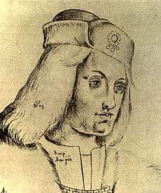
In 1491 Cork played a part in the English Wars of the Roses when Perkin Warbeck, a pretender to the English throne, landed in the city and tried to recruit support for a plot to overthrow Henry VII of England. The Cork people fought with Perkin because he was French and not English, they were the only county in Ireland to join the fight. The mayor of Cork and several important citizens went with Warbeck to England but when the rebellion collapsed they were all captured and executed. Cork's nickname of the 'rebel city' originates in these events.
In 1601 the decisive Battle of Kinsale took place in County Cork, which was to lead to English domination of Ireland for centuries. Kinsale had been the scene of a landing of Spanish troops to help Irish rebels in the Nine Years' War (1594–1603). When this force was defeated, the rebel hopes for victory in the war were all but ended. County Cork was officially created by a division of the older County Desmond in 1606.
In the 19th century, Cork was a centre for the Fenians and for the constitutional nationalism of the Irish Parliamentary Party, from 1910 that of the All-for-Ireland Party. The county was a hotbed of guerrilla activity during the Irish War of Independence (1919–1921). Three Cork Brigades of the Irish Republican Army operated in the county and another in the city. Prominent actions included the Kilmichael Ambush in November 1920 and the Crossbarry Ambush in March 1921. The activity of IRA flying columns, such as the one under Tom Barry in west Cork, was popularised in the Ken Loach film The Wind That Shakes The Barley. On 11 December 1920 Cork City centre was gutted by fires started by the Black and Tans in reprisal for IRA attacks. Over 300 buildings were destroyed, many other towns and villages around the county suffered a similar fate including Fermoy.[16]
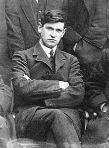
During the Irish Civil War (1922–23), most of the IRA units in Cork sided against the Anglo-Irish Treaty. From July to August 1922 they held the city and county as part of the so-called Munster Republic. However, Cork was taken by troops of the Irish Free State in August 1922 in the Irish Free State offensive, that included both overland and seaborne attacks. For the remainder of the war, the county saw sporadic guerrilla fighting until the Anti-Treaty side called a ceasefire and dumped their arms in May 1923. Michael Collins, a key figure in the War of Independence, was born near Clonakilty and assassinated during the civil war in Béal na Bláth, both in west Cork.
Irish language
County Cork has two Gaeltacht areas where the Irish language is the primary medium of everyday speech. These are Múscraí (Muskerry) in the north of the county, especially the villages of Cill Na Martra (Kilnamartyra), Baile Bhúirne (Ballyvourney), Cúil Aodha (Coolea), Béal Átha an Ghaorthaidh (Ballingeary), and Oileán Chléire (Cape Clear Island).
There are 14,829 Irish language speakers in County Cork with 3,660 native speakers in the Cork Gaeltacht. In addition, in 2011 there were 6,273 pupils attending the 21 Gaelscoileanna and six Gaelcholáistí all across the county.[17] According to the Irish Census 2006 there are 4,896 people in the county who identify themselves as being daily Irish speakers outside of the education system. Ballingeary is a centre for Irish language tuition, with a summer school, Coláiste na Mumhan, or the College of Munster.
Anthem
The song "The Banks Of My Own Lovely Lee" is traditionally associated with the county. It is sometimes heard at GAA and other sports fixtures involving the county.[18]
Media
There are several media publications printed and distributed in County Cork. These include the Irish Examiner (formerly the Cork Examiner) and its sister publication The Echo (formerly the Evening Echo). Local and regional newspapers include The Cork News,[19] Carrigdhoun, the Cork Independent, The Corkman, the Mallow Star, the Douglas Post, the East Cork Journal and the Southern Star.
Local radio stations include Cork's 96FM and dual-franchise C103, CRY 104.0FM and Red FM.
Places of interest
Tourist sites include the Blarney Stone and Cobh, the port where many Irish emigrants boarded for their voyage to Australia, Canada, New Zealand, South Africa or the United States and also the last stop of the Titanic, before departing on its fated journey. It is home to the World's Oldest Yacht Club, the Royal Cork Yacht Club in Crosshaven.
Fota Island is the only wildlife park in Ireland, Fota House and Gardens, and the Fota Golf Club and Resort; a European Tour standard golf course which has also hosted the Irish Open in 2001, 2002 and 2014.
West Cork is known for its rugged natural environment, beaches and social atmosphere and is a destination for British, German, French and Dutch tourists.
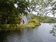 St Finbar's church, Gougane Barra. 6th century site
 Saint Fin Barre's Cathedral, Cork city. 7th century site
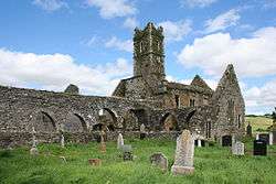 Timoleague Friary, west cork, founded 1240
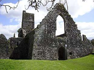 Kilcrea Friary, mid cork. Founded 1465
Economy
The South-West region comprising counties Cork and Kerry contribute € 24,877 million (US$39.3 billion) (2005 values; 2008 exchange rate) towards the Irish GDP.[20] The harbour area to the immediate east of the city is home to many pharmaceutical and medical companies. Mahon Point Shopping Centre is Cork's largest, and Munster's second largest, shopping centre and has over 75 stores including a retail park.
The Golden Vale is among the most productive farmland for dairy in Ireland. The chief milk processor is Dairygold, a farmer-owned co-operative based in Mitchelstown, who process 1.4 billion liters a year, converting the milk into cheeses and powder dairy nutritionals for infant formula.[21]
Transport
Cork's main transport is serviced from:
- Air: Cork International Airport
- Rail: Iarnród Éireann's InterCity, Commuter and Freight rail services
- Sea: Port of Cork at Cork Harbour
Demographics
| Leading population centres | ||||||
|---|---|---|---|---|---|---|
| Rank | City/Town | Population (2016)[22] | 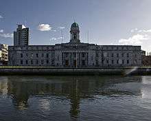 Cork (County Capital) 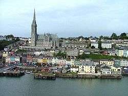 Cobh | |||
| 1 | Cork | 208,669 | ||||
| 2 | Ballincollig | 18,621[23] | ||||
| 3 | Carrigaline | 15,770 | ||||
| 4 | Cobh | 12,800 | ||||
| 5 | Midleton | 12,496 | ||||
| 6 | Mallow | 12,459 | ||||
| 7 | Youghal | 7,963 | ||||
| 8 | Bandon | 6,957 | ||||
| 9 | Fermoy | 6,585 | ||||
| 10 | Blarney & Tower | 6,014 | ||||
| 11 | Passage West | 5,843 | ||||
| 12 | Kinsale | 5,281 | ||||
| 13 | Carrigtwohill | 5,080 | ||||
| 14 | Clonakilty | 4,592 | ||||
Cork city is the only city in the county and the second most populous city in the Republic of Ireland, with a population of 125,657 according to the 2016 census.[3] Cork city is the third most populous city on the island of Ireland. According to the 2006 Census statistics, the county has 11 towns with a population of over 4,000. The county has a population density of 72 persons/km2. A large percentage of the population live in urban areas.
As of the 2011 census, ethnically the population included 85% white Irish people, 9% other white people, 1% black, 1% Asian, 1% other races, and 1% not stated.[24] Catholicism is the main religion at 87%, with other religions at 7%, 5% of people stating that they had no religion, and 1% not stated.[24]
People
Common surnames in the county include Barry, Buckley, Callaghan, Connell, Connor, Crowley, Lynch, McCarthy, Murphy, O'Leary, O'Sullivan, Sheehan, Walsh, and Fitzgerald (the latter with a Norman derivation).[25][26][27]
See also
- List of abbeys and priories in the Republic of Ireland (County Cork)
- Regional accents of English
References
- "What's your Irish County? County Cork". IrishCentral.com. 14 October 2016.
- "Stats Facts about your County - Cork". cso.ie. Central Statistics Office. Archived from the original on 14 November 2011.
Area (Source: Ordnance Survey) / 749,995 Hectares
- "Census 2016 Sapmap Area: County Cork City". Central Statistics Office (Ireland). Retrieved 18 November 2018.
- "Census 2016 Sapmap Area: County Cork County". Central Statistics Office (Ireland). Retrieved 18 November 2018.
- "Ireland's most popular tourist counties and attractions have been revealed". TheJournal.ie. 23 July 2017. Retrieved 15 October 2017.
the southwest, comprising Cork and Kerry, has the second-largest spend by tourists [after the Dublin region]
- "If not for collins, why is it called the rebel county?". Independent.ie.
- "Placenames Database of Ireland. Retrieved January 21, 2012". Logainm.ie. 13 December 2010. Archived from the original on 8 July 2013. Retrieved 23 May 2012.
- C. Michael Hogan. 2009. Hooded Crow: Corvus cornix, GlobalTwitcher.com, ed, N. Stromberg Archived 26 November 2010 at the Wayback Machine
- Cullinane, J.P. 1973 Phycology of the South Coast of Ireland. University College Cork
- "Cape Clear Island: a birdwatching bonanza". Lonely Planet. 20 September 2019.
- Ireland, BirdWatch. "Cape Clear Bird Observatory". www.birdwatchireland.ie. Retrieved 18 November 2017.
- Whooley, Pádraig. "Wild waters: the lesser-known life of whales and dolphins along the Irish coastline". The Irish Times. Retrieved 18 November 2017.
- Fáilte Ireland. "Whale Watching & Dolphin Watching in Ireland – Wild Atlantic Way". www.wildatlanticway.com. Retrieved 18 November 2017.
- Jones, Calvin (23 August 2016). "How to watch whales and dolphins – whalewatching tips and advice". Ireland's Wildlife. Retrieved 18 November 2017.
- for post 1821 figures 1653 and 1659 figures from Civil Survey Census of those years Paper of Mr Hardinge to Royal Irish Academy March 14, 1865 For a discussion on the accuracy of pre-famine census returns see JJ Lee “On the accuracy of the pre-famine Irish censuses” in Irish Population Economy and Society edited by JM Goldstrom and LA Clarkson (1981) p54 in and also New Developments in Irish Population History 1700–1850 by Joel Mokyr and Cormac Ó Gráda in The Economic History Review New Series Vol. 37 No. 4 (November 1984) pp. 473–488.
- "Rebelcork.com". Rebelcork.com. Archived from the original on 2 April 2012. Retrieved 23 May 2012.
- "Oideachas Trí Mheán na Gaeilge in Éirinn sa Ghalltacht 2010–2011" (PDF) (in Irish). gaelscoileanna.ie. 2011. Retrieved 9 January 2012.
- "Corkindependent.com". Corkindependent.com. 27 August 2009. Archived from the original on 21 August 2010. Retrieved 23 May 2012.
- "Thecorknews.ie". Thecorknews.ie. 19 April 2012. Retrieved 23 May 2012.
- "Cork / Kerry GDP" (PDF). Central Statistics Office. Archived from the original (PDF) on 19 November 2011.
- "Dairygold opens €85m facility at Mallow headquarters". RTÉ. 22 September 2017. Retrieved 16 November 2017.
- "Population Density and Area Size 2016". Central Statistics Office (Ireland). Retrieved 26 December 2017.
- "Census 2016 Sapmap Area: Electoral Division Ballincollig". Census 2016. Central Statistics Office. Retrieved 26 December 2017.
- "County Cork (CSO Area Code CTY 18)". Census 2011. Central Statistics Office. Retrieved 5 April 2019.
- "Popular Cork surnames and families". Rooteireland.ie. Retrieved 26 June 2018.
- "CORK". John Grenham. Retrieved 26 June 2018.
- "Cork". irishgenealogy.com. Retrieved 26 June 2018.
External links
| Wikimedia Commons has media related to County Cork. |
| Wikisource has the text of an 1879 American Cyclopædia article about County Cork. |
| Wikivoyage has a travel guide for County Cork. |
Places adjacent to County Cork | |
|---|---|
The counties are listed per province | ||
 | ||
| ||
| Authority control |
|
|---|