Golden Vale
The Golden Vale (Irish: Machaire méith na Mumhan)[1] is an area of rolling pastureland in the civil province of Munster, southwestern Ireland. Covering parts of three counties, Limerick, Tipperary and Cork, it is the best land in Ireland for dairy farming.[1][2] Historically it has been called the Golden Vein. An early instance is an 1837 book by Jonathan Binns, a British government official, where he refers to the area as '"the golden vale" (more correctly the "golden vein")'[3] and states "The land is of excellent quality, being part of the golden vein of Ireland—a district reaching from Tipperary towards Limerick. The extent of the golden vein is about fourteen miles long, by six or seven wide."[4] Some subsequent writers similarly prefer "vein".[2][5][6]

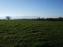
The Golden Vale is bordered in the east by the Galtee Mountains, with the Glen of Aherlow as a picturesque abutting valley. The Munster Blackwater valley is the Vale's southern part. Towns in the Golden Vale include Charleville, Mitchelstown, Kilmallock and Tipperary.[2] From Tipperary town, Aherlow, Bansha and Cahir, and then south to Mitchelstown, Kildorrery, Mallow and Charleville, this 'square' could be considered the best land in Ireland. In 1739, Walter Harris suggested the "Golden" name was a corruption of Gowlin,[7] former name of a village now called Golden, from Irish: An Gabhailín "little fork [in the River Suir]".[8]
Sources
-
Ó Giolláin, Diarmuid (June 2005). "The national and the local — practices of de- and retraditionalization" (PDF). FF Network. The Folklore Fellows (28): 17,fn.5. ISSN 0789-0249. Archived from the original (PDF) on 2009-03-18. Retrieved 2009-03-08.
"Machaire méith na Mumhan", usually referred to as the Golden Vale, the richest dairy land in Ireland
-
Freeman, T. W. (July–September 1947). "Farming in Irish Life". The Geographical Journal. Blackwell Publishing on behalf of The Royal Geographical Society. 110 (1/3): 48, fn.1. doi:10.2307/1789193.
The Golden Vein (sometimes called the Golden Vale) consists of the lowlands of Co. Limerick with an extension towards Tipperary and Cashel and a southward extension to the neighbourhood of Charleville and Mallow. In effect it is the heart of the Munster dairying country.
- Binns, Jonathan (1837). Miseries and beauties of Ireland. Vol.2. Longman, Orme, Brown and co. |page=101
- Binns, p.161
-
Unstead, John Frederick (1960). The British Isles. A systematic regional Geography. 1. London University Press. p. 261. OCLC 255935608.
the relatively broad hollow called the Vale of Limerick, and sometimes known as the "Golden Vale" or, more correctly, the "Golden Vein".
-
Meagher, Jim (28 February 1987). "Hardships of service in days of the 'Spailpín'". Southern Star. p. 10.
North Cork, County Limerick and West Tipperary areas, in other words, the rich and fertile land of the "Golden Vein" (now incorrectly termed "Golden Vale" — there is no vale).
- Ware, Sir James (1739). Harris, Walter (ed.). History of the Bishops of the Kingdom of Ireland. The Whole Works of Sir James Ware Concerning Ireland. I. Dublin: E. Jones. p. 20, fn.†. Retrieved 2 March 2019.
- Mills, A. D. (2003). A Dictionary of British Place-Names. Oxford: OUP. ISBN 9780191578472. Retrieved 2 March 2019.
Further reading
- The golden vale of Ivowen: between Slievenamon and Suir Eoghan Ó Néill 2001 ISBN 978-0-906602-91-1
- The book of the Galtees and the Golden Vein: a border history of Tipperary, Limerick & Cork Paul J. Flynn, 1926