County Down
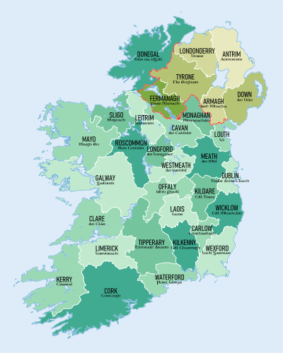
County Down (Irish: Contae an Dúin) is one of six counties that form Northern Ireland, in the northeast of the island of Ireland.[3][4] It covers an area of 2,448 km2 (945 sq mi) and has a population of 531,665. It is also one of the thirty-two traditional counties of Ireland and is within the province of Ulster. It borders County Antrim to the north, the Irish Sea to the east, County Armagh to the west, and County Louth across Carlingford Lough to the southwest.
County Down Contae an Dúin Coontie Doon/Countie Doun | |
|---|---|
 Coat of arms | |
| Nickname(s): Mourne Country | |
| Motto(s): Absque Labore Nihil (Latin) "Nothing Without Labour" | |
 | |
| Country | United Kingdom |
| Region | Northern Ireland |
| Province | Ulster |
| Established | early 16th century |
| County town | Downpatrick |
| Area | |
| • Total | 952 sq mi (2,466 km2) |
| Area rank | 12th |
| Highest elevation | 2,790 ft (850 m) |
| Population (2011) | 531,665 |
| • Rank | 4th |
| Time zone | UTC±0 (GMT) |
| • Summer (DST) | UTC+1 (BST) |
| Postcode area | |
| Website | discovernorthernireland |
| Contae an Dúin is the Irish name, Countie Doun[1] and Coontie Doon[2] are Ulster Scots spellings. | |
In the east of the county is Strangford Lough and the Ards Peninsula. The largest town is Bangor, on the northeast coast. Three other large towns and cities are on its border: Newry lies on the western border with County Armagh, while Lisburn and Belfast lie on the northern border with County Antrim. Down contains both the southernmost point of Northern Ireland (Cranfield Point) and the easternmost point of Ireland (Burr Point).
It was one of two counties of Northern Ireland to have a Protestant majority at the 2001 census. The other Protestant majority County is County Antrim to the North.
In March 2018, The Sunday Times published its list of Best Places to Live in Britain, including five in Northern Ireland. The list included three in County Down: Holywood, Newcastle, and Strangford.[5]
Toponymy
County Down takes its name from dún, the Irish word for dun or fort, which is a common root in Gaelic place names (such as Dundee, Dunfermline and Dumbarton in Scotland and Donegal and Dundalk in Ireland).[6] The fort in question was in the historic town of Downpatrick, originally known as Dún Lethglaise ("fort of the green side" or "fort of the two broken fetters").[7][8]
History
.jpg)
During the Williamite War in Ireland (1689–1691) the county was a centre of Protestant rebellion against the rule of the Catholic James II. After forming a scratch force the Protestants were defeated by the Irish Army at the Break of Dromore and forced to retreat, leading to the whole of Down falling under Jacobite control. Later the same year Marshal Schomberg's large Williamite expedition arrived in Belfast Lough and captured Bangor. After laying siege to Carrickfergus Schomberg marched south to Dundalk Camp, clearing County Down and much of the rest of East Ulster of Jacobite troops.
Geography
Down contains two significant peninsulas: Ards Peninsula and Lecale peninsula.
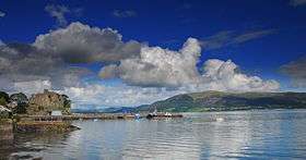
The county has a coastline along Belfast Lough to the north and Carlingford Lough to the south (both of which have access to the sea). Strangford Lough lies between the Ards Peninsula and the mainland. Down also contains part of the shore of Lough Neagh. Smaller loughs include Lough Island Reavy.
The River Lagan forms most of the border with County Antrim. The River Bann also flows through the southwestern areas of the county. Other rivers include the Clanrye and Quoile.
There are several islands off the Down coast: Mew Island, Light House Island and the Copeland Islands, all of which lie to the north of the Ards Peninsula. Gunn Island lies off the Lecale coast. In addition, there are a large number of small islands in Strangford Lough.
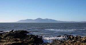
County Down is where, in the words of the song by Percy French, "The mountains of Mourne sweep down to the sea", and the area around the granite Mourne Mountains continues to be known for its scenery. Slieve Donard, at 849 m (2,785 ft), is the highest peak in the Mournes, in Northern Ireland and in the province of Ulster. Another important peak is Slieve Croob, at 534 m (1,752 ft), the source of the River Lagan.
Places of interest
- An area of County Down is known as the Brontë Homeland (situated between Rathfriland and Banbridge, where Patrick Brontë had his church.) Patrick Brontë (originally Brunty), father of Anne, Charlotte, Emily and Branwell. Patrick Brontë was born in this region.
- The city of Newry in the south of the county contains St Patrick's (Church of Ireland, 1578), overlooking the city centre from Church street, on the east side of the city, which is considered to be Ireland's first ever Protestant church.[9] The Newry Canal is also the first summit-level canal ever to be built in the British Isles.
- Castlewellan Forest Park.
- Cloughmore (The Big Stone), a 30-ton Granite boulder lies on the Slieve Martin Mountain Ridge approximately 1000 ft. above Rostrevor village
- Down is also home to Exploris, the Northern Ireland Aquarium, located in Portaferry, on the shores of Strangford Lough, on the Ards Peninsula.
- The Old Inn in Crawfordsburn is one of Ireland's oldest hostelries, with records dating back to 1614. It is predated however by Donaghadee's Grace Neill's which was opened in 1611. The Old inn claims that people who have stayed there include Jonathan Swift, Dick Turpin, Peter the Great, Lord Tennyson, Charles Dickens, Anthony Trollope, former US president George H. W. Bush, and C. S. Lewis, who honeymooned there.[10]
- Tollymore Forest Park.
- Scrabo Tower, in Newtownards, was built as a memorial to Charles Stewart, 3rd Marquess of Londonderry.
- Saint Patrick is reputed to be buried at Down Cathedral in Downpatrick, reputedly alongside St. Brigid and St. Columcille.[11]
- Saul, County Down (from the Irish: Sabhall meaning "Barn") – where Saint Patrick said his first eucharist in Ireland
Subdivisions
Baronies
- Ards Lower (from the Irish: Aird)
- Ards Upper
- Castlereagh Lower
- Castlereagh Upper
- Dufferin (from the Irish: Duifrian)
- Iveagh Lower, Lower Half (from the Irish: Uíbh Eachach)
- Iveagh Lower, Upper Half
- Iveagh Upper, Lower Half
- Iveagh Upper, Upper Half
- Kinelarty (from the Irish: Cineál Fhártaigh)
- Lecale Lower (from the Irish: Leath Cathail)
- Lecale Upper
- Lordship of Newry
- Mourne (from the Irish: Múrna)
Parishes
Townlands
Settlements
| Historical population | ||
|---|---|---|
| Year | Pop. | ±% |
| 1653 | 13,207 | — |
| 1659 | 15,183 | +15.0% |
| 1821 | 325,410 | +2043.3% |
| 1831 | 352,012 | +8.2% |
| 1841 | 361,446 | +2.7% |
| 1851 | 320,817 | −11.2% |
| 1861 | 299,302 | −6.7% |
| 1871 | 277,294 | −7.4% |
| 1881 | 248,190 | −10.5% |
| 1891 | 224,008 | −9.7% |
| 1901 | 205,889 | −8.1% |
| 1911 | 204,303 | −0.8% |
| 1926 | 209,228 | +2.4% |
| 1937 | 210,687 | +0.7% |
| 1951 | 241,181 | +14.5% |
| 1961 | 266,939 | +10.7% |
| 1966 | 286,631 | +7.4% |
| 1971 | 311,876 | +8.8% |
| 1981 | 417,978 | +34.0% |
| 1991 | 454,411 | +8.7% |
| 2001 | 489,004 | +7.6% |
| 2011 | 531,665 | +8.7% |
| [12][13][14][15][16][17] | ||
Cities
(population of 75,000 or more at 2001 Census)[18]
- Belfast - the eastern suburbs of the city lie partly in County Down but mainly County Antrim
- Lisburn - the eastern suburbs of the city lie partly in County Down but mainly County Antrim
- Newry
Large towns
(population of 18,000 or more and under 75,000 at 2001 Census)[18]
Medium towns
(Population of 10,000 or more and under 18,000 at 2001 Census)[18]
Small towns
(Population of 4,500 or more and under 10,000 at 2001 Census)[18]
- Ballygowan
- Ballynahinch
- Comber
- Donaghadee
- Dromore
- Kilkeel
- Newcastle
- Saintfield
- Warrenpoint
Intermediate settlements(population of 2,250 or more and under 4,500 at 2001 Census)[18] Villages(population of 1,000 or more and under 2,250 at 2001 Census)[18]
|
Small villages or hamlets(Population of less than 1,000 at 2001 Census)[18]
|
Administration
The county was administered by Down County Council from 1899 until the abolition of county councils in Northern Ireland in 1973.[19] County Down is now served by the following local government districts:
- Ards and North Down
- Newry, Mourne and Down (also serves part of County Armagh)
- Lisburn and Castlereagh (also serves part of County Antrim)
- Belfast (also serves part of County Antrim)
- Armagh City, Banbridge and Craigavon (also serves parts of County Armagh and County Antrim)
Transportation
Railways
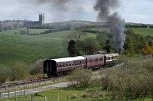
Former railways within the county include the Great Northern Railway of Ireland and Belfast and County Down Railway both of which were formed in the 19th century and were closed (or amalgamated) in the 1950s. The Downpatrick and County Down Railway operates a short section of the former Belfast and County Down line as a heritage railway between Downpatrick and Inch Abbey.
Northern Ireland Railways operates the area's modern rail network.
Sport
Association football
In association football, the NIFL Premiership, which operates as the top division, has three teams in the county: Newry City F. C., Ards F.C. and Warrenpoint Town F.C., with Banbridge Town F.C., Bangor F.C. and Lisburn Distillery F.C. competing in the NIFL Championship, which operates as levels two and three.
Gaelic games
The Down County Board administers Gaelic games in the county. Down is the most successful team north of the border in terms of All-Ireland Senior Football Championships won with five (1960, 1961, 1968, 1991 and 1994) in total. In terms of Ulster, they share that accolade with Cavan who also have 5 titles. They currently have four minor All-Ireland titles, twelve Ulster titles and one under 21 all Ireland title (1979).
Golf
County Down is also home to the No.1-ranked golf course outside of the US, according to Today's Golfer, Royal County Down, which is situated in Newcastle.
Currently ranked No.1 golfer in the world, Rory McIlroy originates from Holywood, situated in the north of the county.
In popular culture
"Star of the County Down" is a popular Irish ballad.
The county is named in the lyrics of the song "Around the World", from the film Around the World in 80 Days, which was an American top ten hit for Bing Crosby and UK top ten hit for Ronnie Hilton, both in 1957, although it was Mantovani's instrumental version which was actually used in the film. Rihanna's video "We Found Love" was filmed there in 2011, causing complaints when the singer removed her clothes to reveal a bikini.[20]
The Ulster singer Van Morrison has made reference to the County Down in the lyrics to several songs including "Northern Muse (Solid Ground)", "Mystic of the East" and the nostalgic "Coney Island", which names several places and landmarks in the County. Van Morrison also covered "Star of the County Down" with The Chieftains as a part of their collaboration album Irish Heartbeat.
C.S. Lewis, author of The Chronicles of Narnia, was inspired by the Mourne Mountains. There is a Narnia trail in Kilbroney Park, in Rostrevor<https://www.visitmournemountains.co.uk/ChroniclesofNarnia>.
Sam Hanna Bell based his novel of Ulster rural life, December Bride (1951) in the Ards peninsula. A film version of the novel, also called December Bride, was produced in 1990 and released in November 1991.
Notable people
- Ash, rock band, from Downpatrick
- Paddy Ashdown, former Liberal Democrats (UK) leader, brought up near Comber
- Joseph Barcroft, scientist, Newry
- Colin Blakely, actor, Bangor
- Christine Bleakley, TV Presenter was born in Newtownards
- Patrick Brontë, father of the authors Charlotte, Emily, and Anne Brontë, Rathfriland
- Comgall, saint and founder of the great monastery at Bangor
- Stephen Craigan, Motherwell and Northern Ireland defender, from Newtownards
- Jamie Dornan, actor in 50 Shades of Grey is from Holywood
- Harry Ferguson, inventor of modern tractor, Dromore
- Brian Faulkner, Baron Faulkner of Downpatrick, last Prime Minister of Northern Ireland, Helen's Bay
- Patricia Ford, first female MP from Northern Ireland, Donaghadee
- Charles de Gaulle, French President and founder of the French Fifth Republic, descended from the McCartan family from Kinelarty
- Keith Gillespie, former Manchester United & Newcastle professional footballer grew up in Bangor
- Craig Gilroy, Ulster Rugby winger, raised in Bangor
- Betsy Gray, heroine of the 1798 rebellion, Gransha, Bangor
- Bear Grylls, Chief scout and TV personality Bear was raised in Donaghadee
- Frederick Hamilton-Temple-Blackwood, 1st Marquess of Dufferin and Ava, Governor-General of Canada, Viceroy of India, Clandeboye Estate
- Henry Harrison, Parnellite Member of Parliament, Holywood
- Sarah Cecilia Harrison, artist and first woman councillor to serve on Dublin Corporation, Holywood
- David Healy Northern Ireland record goalscorer is from Killyleagh
- Eddie Irvine, racing driver, Newtownards
- E. Neville Isdell, former chair and CEO of The Coca-Cola Company, Downpatrick
- Pat Jennings, former NI goalkeeper is from Newry
- Patrick Kielty, comedian and television presenter, Dundrum
- Gary Lightbody, lead singer of Snow Patrol, Bangor
- Josh Magennis, Professional footballer currently for Bolton Wanderers F.C. from Bangor
- James Martin, inventor of the ejector seat, from Crossgar
- Robert Blair Mayne, lieutenant colonel and commanding officer of the 1st SAS Regiment, Newtownards
- Aodh MacCathmhaoil, Roman Catholic Archbishop of Armagh and Primate of all Ireland, Saul, County Down
- Rhys McClenaghan - International gymnast from Newtownards
- Edward McGarry, Wisconsin politician
- Rory McIlroy, major champion golfer, from Holywood
- Deirdre McKay, composer
- F.E. McWilliam, sculptor, Banbridge
- Colin Middleton, Irish artist and surrealist, lived in Bangor
- John Mitchel, Irish nationalist, Young Ireland movement, Newry
- Colin Murray, sports TV Presenter, is from Dundonald
- Richard Murray, Provost of Trinity College Dublin 1795-1799, born in County Down
- Kristian Nairn, portrayed Hodor in Game Of Thrones is from Lisburn
- Lembit Öpik, former Liberal Democrat MP and Shadow Welsh and Shadow Northern Ireland Secretary, Bangor
- Francis Rawdon-Hastings, Governor-General of India, 1813 - 1823, Moira
- Margaret Ritchie, Baroness Ritchie of Downpatrick, former leader of Social Democratic and Labour Party and MP, Downpatrick
- Charles Russell, Baron Russell of Killowen, first Roman Catholic Lord Chief Justice of England and Wales, Newry
- Zöe Salmon, TV presenter and Miss UK contestant is from Bangor
- Neil Shawcross, artist, lives in Hillsborough
- Hans Sloane, founder of the British Museum, Killyleagh
- Robert Stewart, Viscount Castlereagh, British Foreign Secretary and diplomat at Congress of Vienna, brought up in family seat Mount Stewart
- David Trimble, Baron Trimble, former First Minister of Northern Ireland, former Ulster Unionist Party leader, Bangor
- Foy Vance, singer-songwriter, Bangor
- Charles Vane-Tempest-Stewart, 7th Marquess of Londonderry, Secretary of State for Air, Leader of the House of Lords, Mount Stewart
- Paddy Wallace, rugby union footballer for Ulster and Ireland, Dundonald
- Thomas L. Young, U.S. politician, 33rd Governor of the State of Ohio, Killyleagh
See also
- Abbeys and priories in Northern Ireland (County Down)
- List of places in County Down
- Lord Lieutenant of Down
- High Sheriff of Down
References
- 2008 Annual Report in Ulster Scots Archived 29 August 2011 at the Wayback Machine North–South Ministerial Council.
- 2006 Annual Report in Ulster Scots Archived 27 February 2013 at the Wayback Machine North–South Ministerial Council.
- Taylor, Isaac. Names and Their Histories. Rivingtons, 1898. p.111
- Lewis, Samuel. A Topographical Dictionary of Ireland (1837); "The See of Down".
- https://www.irishpost.com/life-style/five-places-in-northern-ireland-included-in-best-places-to-live-in-britain-list-151651
- Long, David (2015). Lost Britain: An A-Z of Forgotten Landmarks and Lost Traditions. Michael O'Mara Books. p. 65. ISBN 9781782434412. Retrieved 6 April 2018.
- Praeger, Robert Lloyd (1900). Official Guide to County Down and the Mourne Mountains. M'Caw, Stevenson & Orr. p. 123. Retrieved 6 April 2018.
Dún county down.
- Chisholm, Hugh, ed. (1922). Encyclopedia Britannica: A Dictionary of Arts, Sciences, Literature and General Information. University Press. p. 460. Retrieved 6 April 2018.
- "Saint Patrick's Church". Encyclopedia Britannica. Retrieved 6 July 2017.
- Crawfordsburn Old Inn website
- Kearcsadmin. "St. Brigid's Day". County Kildare Archaeological Society. Retrieved 6 July 2017.
- For 1653 and 1659 figures from Civil Survey Census of those years, Paper of Mr Hardinge to Royal Irish Academy 14 March 1865.
- Census for post 1821 figures.
- Histpop.org Archived 7 May 2016 at the Wayback Machine
- NISRA.gov.uk Archived 17 February 2012 at the Wayback Machine
- Lee, JJ (1981). "On the accuracy of the Pre-famine Irish censuses". In Goldstrom, J. M.; Clarkson, L. A. (eds.). Irish Population, Economy, and Society: Essays in Honour of the Late K. H. Connell. Oxford, England: Clarendon Press.
- Mokyr, Joel; O Grada, Cormac (November 1984). "New Developments in Irish Population History, 1700–1850". The Economic History Review. 37 (4): 473–488. doi:10.1111/j.1468-0289.1984.tb00344.x. hdl:10197/1406.
- "Statistical classification of settlements". NI Neighbourhood Information Service. Retrieved 23 February 2009.
- "Local Government Act (Northern Ireland) 1972". Legislation.gov.uk. Retrieved 29 November 2019.
- "Rihanna video: Wildflowers to be planted in north Belfast 'hopeless place'". BBC. Retrieved 6 July 2017.
Further reading
- Harris, Walter (attributed). 1744. The Ancient and Present Stare of the County of Down...'Dublin.
- The Memoirs of John M. Regan, a Catholic Officer in the RIC and RUC, 1909–48, Joost Augusteijn, editor, District Inspector, Co. Down 1930s, 1919, ISBN 978-1-84682-069-4.
External links
| Wikimedia Commons has media related to County Down. |
| Wikivoyage has a travel guide for County Down. |
- County Down at Curlie
- Culture Northern Ireland – Industrial Heritage of County Down
- . Encyclopædia Britannica (11th ed.). 1911.
Places adjacent to County Down | ||||||||||
|---|---|---|---|---|---|---|---|---|---|---|
| ||||||||||
The counties are listed per province | ||
 | ||
| ||
| Authority control |
|
|---|