Dún Laoghaire–Rathdown
Dún Laoghaire–Rathdown (Irish: Dún Laoghaire–Ráth an Dúin[2]) is a county in Ireland. It is part of the Dublin Region in the province of Leinster. It is named after the former borough of Dún Laoghaire and the barony of Rathdown. Dún Laoghaire–Rathdown County Council is the local authority for the county. The population of the county was 218,018 at the time of the 2016 census.[1]
Dún Laoghaire–Rathdown Dún Laoghaire–Ráth an Dúin | |
|---|---|
County | |
 Coat of arms | |
| Motto(s): | |
 | |
| Country | Ireland |
| Province | Leinster |
| Dáil Éireann | Dún Laoghaire, Dublin Rathdown |
| EU Parliament | Dublin |
| Established | 1994 |
| County town | Dún Laoghaire |
| Government | |
| • Type | County Council |
| Area | |
| • Total | 127.31 km2 (49.15 sq mi) |
| Highest elevation (Two Rock) | 536 m (1,759 ft) |
| Population (2016)[1] | |
| • Total | 218,018 |
| • Density | 1,700/km2 (4,400/sq mi) |
| Time zone | UTC±0 (WET) |
| • Summer (DST) | UTC+1 (IST) |
| Vehicle index mark code | D |
| Website | www |
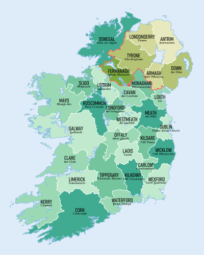
Geography and political subdivisions
Dún Laoghaire–Rathdown is bordered to the east by the Irish Sea, to the north by the local government area of Dublin City Council, to the west by the county of South Dublin and to the south by County Wicklow. University College Dublin and Dún Laoghaire Institute of Art, Design and Technology are located in the county. It is one of four entities that comprise the "Dublin Region": the three smaller counties into which County Dublin was divided in 1994, along with the city of Dublin. Located to the south-east of the capital city of Dublin, the county town of Dún Laoghaire–Rathdown is Dún Laoghaire. It was created in 1994 by merging the areas under the jurisdiction of the Corporation of Dún Laoghaire and the south-eastern part of the former Dublin County Council. Additionally, the powers of the former Deansgrange Joint Burial Board were subsumed into the new authority. Since 2015, the county lies within the Eastern & Midland Regional Authority, one of three such subdivisions of the state.
Towns, villages and suburbs
- Ballinteer
- Ballybrack
- Ballyogan
- Blackrock
- Booterstown
- Belfield
- Cabinteely
- Carrickmines
- Cherrywood
- Churchtown
- Clonskeagh
- Dalkey
- Deansgrange
- Dundrum
- Dún Laoghaire
- Foxrock
- Goatstown
- Glasthule
- Glenageary
- Glencullen
- Johnstown
- Killiney
- Kilmacud
- Kilternan
- Leopardstown
- Loughlinstown
- Monkstown
- Mount Merrion
- Rathfarnham
- Sandyford
- Sandycove
- Sallynoggin
- Shankill
- Stepaside
- Stillorgan
- Ticknock
Naming
The coastal town of Dún Laoghaire (called Dunleary until 1821 and then Kingstown until 1920) gave its name to the larger borough of Dún Laoghaire established in 1930 with powers nearly as great as a county borough. Rathdown was the south-easternmost barony in County Dublin, named after Rathdown Castle. When County Wicklow was created south of County Dublin in 1606, half of Rathdown was transferred to Wicklow, including Rathdown Castle, now a ruin. From the 1840s, the poor law union (PLU) of Rathdown covered all of the Wicklow barony and most of the Dublin barony, with part of Uppercross. From the Dublin and Wicklow sections of the PLU, the Local Government (Ireland) Act 1898 created rural districts respectively named Rathdown No. 1 and Rathdown No. 2, abolished in 1930 and 1925. Rathdown PLU survived as Rathdown Public Assistance District until 1960.[3]
Dún Laoghaire and Rathdown was a Dáil Éireann constituency created by the Electoral (Amendment) Act 1947 coterminous with the former Rathdown No. 1 rural district.[4] The name "Dún Laoghaire-Rathdown" was given to the "electoral county" created by the Local Government (Reorganisation) Act 1985.[5] An "area committee" for the electoral county was formed within Dublin County Council under the Local Government Act 1991,[6] and discussed possible alternative names before deciding to retain "Dún Laoghaire-Rathdown".[7] The Local Government (Dublin) Act 1993 made it an "administrative county" on the same basis as those created by the 1898 act. The 1993 act named it "Dun Laoghaire-Rathdown" in English, omitting the síneadh fada on the "u" of "Dun", while retaining it in the Irish name Dún Laoghaire-Ráth an Dúin.[8] The 1993 act empowered Dún Laoghaire–Rathdown County Council (DLRCC) to apply to change the county's name,[8] but this was not invoked.[nb 1] The 1993 spelling is retained by the Local Government Act 2001,[10] and the Local Government Reform Act 2014.[11] Nevertheless, DLRCC[nb 2] and the Placenames Database of Ireland[2] use "Dún Laoghaire–Rathdown" (with síneadh fada) in English.
Whereas it is common to refer to those Irish counties which predate 1898 with the word "County" before the name (such as "County Dublin", "County Clare") this is less so for those created later,[nb 3] and "County Dún Laoghaire–Rathdown" is rare.
Local government and politics

Dún Laoghaire–Rathdown County Council is the local authority for the county. There are six Local Electoral Areas (LEAs) for the county which return a total of 40 councillors as follows: Killiney-Shankill (6), Blackrock (6), Dundrum (7), Dún Laoghaire (8), "Glencullen/Sandyford" (7), Stillorgan (6).
In 1986, the "administrative county" of Dublin was divided into three "electoral counties": Dún Laoghaire–Rathdown, Dublin — Fingal, and Dublin — Belgard.[13] In 1994, Dublin County Council and the Corporation of Dún Laoghaire were abolished and the three electoral counties became "administrative counties", named Dún Laoghaire–Rathdown, Fingal, and South Dublin respectively.[14] In 2001, the "administrative counties" were redesignated as simply "counties". The three counties together with Dublin city constitute the Dublin Region. The label "County Dublin" continues to be used informally for this area (the city has been administered separately from County Dublin since 1548).
For elections to Dáil Éireann, the county is split between the constituencies of Dún Laoghaire (4 representatives) and Dublin Rathdown (3 representatives), with the division generally running along the N11. These constituencies currently have four Fine Gael TDs, one Green Party TD, one Solidarity–People Before Profit TD and one Independent TD.
The Dublin region forms the Dublin constituency in European Parliament elections.
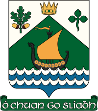
The motto on the insignia of the County Council reads, Ó Chuan go Sliabh, Irish for "From Harbour to Mountain". The crown in the device is that of Lóegaire mac Néill, a legendary 5th-century High King of Ireland and the eponymous Laoghaire of "Dún Laoghaire".
Demographics
| Nationality | Population |
|---|---|
| 11,927 | |
| 3,120 | |
| 2,181 | |
| 1,919 | |
| 1,325 | |
| 1,223 | |
| 1,178 | |
| 1,024 | |
| 953 | |
| 926 |
Transport
The Dublin Area Rapid Transit system runs through the eastern coast of the county and connects to Dublin city centre to the north as well as other points north and south on the Iarnród Éireann railway system, with connections to Intercity trains. The green Luas line runs through the centre of the county.
There is a medium-sized harbour at Dún Laoghaire, with now discontinued ferry crossings to and from Holyhead in North Wales; this was a popular route for tourists travelling across the Irish Sea from Britain. This service was suspended indefinitely in September 2014.
Footnotes
- Section 9 of the 1993 act was repealed by the 2001 act without having been invoked.[9] Since then the default provisions for placename changes apply, requiring a plebiscite of voters rather than a resolution of councillors.
- See for example Annual Reports since 2007
- As evinced by a 2003 statutory instrument which lists both bare and prefixed forms for the older counties but only bare forms for the newer ones.[12]
References
- "Sapmap Area - County - Dún Laoghaire-Rathdown". Census 2016. CSO. 2016. Retrieved 17 January 2018.
- "Dún Laoghaire-Ráth an Dúin/Dún Laoghaire-Rathdown". Logainm.ie (in English and Irish). Retrieved 30 May 2019.
- "Health Authorities Act 1960 s.15(1)(a)". electronic Irish Statute Book (eISB). Retrieved 30 May 2019.
- "Electoral (Amendment) Bill, 1947—Second Stage". Seanad Éireann (5th Seanad) debates. Oireachtas. 19 November 1947. Retrieved 30 May 2019.
- "Local Government (Reorganisation) Act 1985 s.12". electronic Irish Statute Book (eISB). Retrieved 30 May 2019.
- "Local Government Act 1991 s.18". electronic Irish Statute Book (eISB). Retrieved 30 May 2019.
- "Private Members' Business — Local Government (Dublin) Bill, 1993; Report Stage: (Resumed)". Dáil Éireann (27th Dáil) debates. Oireachtas. 7 December 1993. Retrieved 30 May 2019.
- "Local Government (Dublin) Act 1993 s.9". electronic Irish Statute Book (eISB). Retrieved 10 May 2019.
- "Local Government (Dublin) Act 1993 [Commencement, Amendments, SIs made under the Act]". Irish Statute Book. 15 May 2019. Retrieved 30 May 2019.
- "Local Government Act 2001, Schedule 5 Part 1 [as enacted]". electronic Irish Statute Book (eISB). Retrieved 30 May 2019.
- "Local Government Act 2001, Schedule 5 Part 1 [as amended]". Revised Acts. Law Reform Commission. 16 April 2019. Retrieved 30 May 2019.
- "I.R. Uimh. 519/2003 -An tOrdú Logainmneacha (Contaetha agus Cúigí) 2003". electronic Irish Statute Book (eISB) (in Irish and English). Retrieved 30 May 2019.
- "Local Government (Reorganisation) Act, 1985, Section 12". Irish Statute Book. Retrieved 14 February 2014.
"S.I. No. 400/1993 - Local Government (Dublin) Act, 1993 Commencement Order, 1993". Irish Statute Book. Retrieved 14 February 2014. - "S.I. No. 400/1993 - Local Government (Dublin) Act, 1993 Commencement Order, 1993". Irish Statute Book. Retrieved 14 February 2014.
"Local Government (Dublin) Act, 1993". Irish Statute Book. Retrieved 14 February 2014. - "Population Usually Resident and Present in the State 2011 to 2016 by Sex, Aggregate Town or Rural Area, Birthplace, County of Usual Residence and CensusYear - StatBank - data and statistics". www.cso.ie. Retrieved 10 May 2019.
External links
| Wikimedia Commons has media related to Dún Laoghaire-Rathdown. |
- Dún Laoghaire–Rathdown County Council
- Dún Laoghaire–Rathdown County Enterprise Board
- Dún Laoghaire–Rathdown Tourism
Places in Dún Laoghaire–Rathdown | ||
|---|---|---|
| Villages and suburbs |
| |
| ||
Regions of Dublin | ||
|---|---|---|
| Cities |  County Dublin in Ireland | |
| Counties | ||
| Other regions | ||
| Civil sub-divisions | ||
| Baronies of Dublin |
| |