Boggeragh Mountains
The Boggeragh Mountains (Irish: An Bhograch) are located in County Cork, Ireland, with the Munster Blackwater to the north and the River Lee to the south of the hills. With an elevation of 644 m (2,113 ft), the highest peak is Musheramore (Irish: Muisire Mór). The landscape consists of peat blanket bog, grassland, streams and areas of forestry. The mountains were formed from Old Red Sandstone deposited during the Devonian Period. They were shaped by glacial erosion during the last glacial period.
| Boggeragh Mountains | |
|---|---|
| Irish: An Bhograch | |
 Boggeragh Mountains | |
| Highest point | |
| Peak | Musheramore |
| Elevation | 644 m (2,113 ft) |
| Coordinates | 52°01′N 8°55′W |
| Geography | |
| Country | Republic of Ireland |
| Provinces of Ireland | Munster |
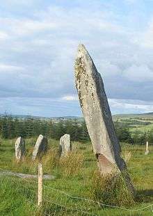
Knocknakilla standing stone on the Boggeragh Mountains
Construction of a wind farm in the area started in September 2009. In February 2010 19 units of Vestas V90-3MW MW wind turbines are up and running.[1]
References
- "Archived copy". Archived from the original on 2009-04-09. Retrieved 2009-01-09.CS1 maint: archived copy as title (link)
Mountains and hills of Munster | |||||||
|---|---|---|---|---|---|---|---|
| Ballyhoura Mountains |  | ||||||
| Boggeragh Mountains | |||||||
| Caha Mountains | |||||||
| Comeragh Mountains | |||||||
| Derrynasaggart Mountains | |||||||
| Dingle Peninsula |
| ||||||
| Galty Mountains | |||||||
| Iveragh Peninsula | |||||||
| Knockmealdown Mountains | |||||||
| MacGillycuddy's Reeks |
| ||||||
| Mangerton Mountains | |||||||
| Shehy Mountains | |||||||
| Silvermine Mountains | |||||||
| Slieve Miskish Mountains | |||||||
| Others |
| ||||||
This article is issued from Wikipedia. The text is licensed under Creative Commons - Attribution - Sharealike. Additional terms may apply for the media files.