County Louth
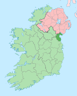
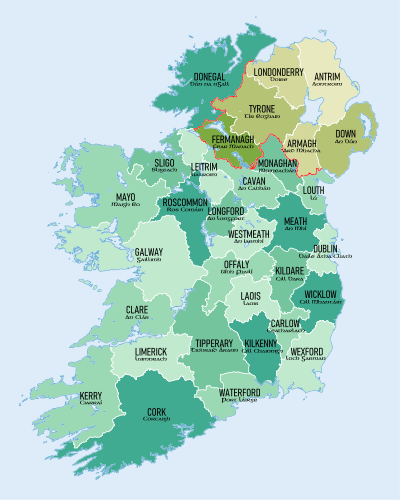
County Louth (/laʊð/[4] Irish: Contae Lú)[5] is a county[6] in the Republic of Ireland. It is in the province of Leinster and is part of the Mid-East Region. It is named after the village of Louth. Louth County Council is the local authority for the county. According to the 2016 census, the population of the county was 128,884.[3]
County Louth Contae Lú | |
|---|---|
 Coat of arms | |
| Nickname(s): The Wee County | |
| Motto(s): | |
 | |
| Country | Ireland |
| Province | Leinster |
| Dáil Éireann | Louth |
| EU Parliament | Midlands–North-West |
| Established | 1210[1][2] |
| County town | Dundalk |
| Government | |
| • Type | County Council |
| Area | |
| • Total | 827 km2 (319 sq mi) |
| Area rank | 32nd |
| Highest elevation (Slieve Foye) | 589 m (1,932 ft) |
| Population (2016)[3] | |
| • Total | 128,884 |
| • Rank | 18th |
| • Density | 160/km2 (400/sq mi) |
| Time zone | UTC±0 (WET) |
| • Summer (DST) | UTC+1 (IST) |
| Eircode routing keys | A91, A92 (primarily) |
| Telephone area codes | 041, 042 (primarily) |
| Vehicle index mark code | LH |
| Website | www |
Geography
County Louth is colloquially known as 'the Wee County' as it is Ireland's smallest county by area (826 km2 319 mi2).[7] It is the 18th-largest in terms of population.[8] It is the smallest of Leinster's 12 counties by size and the sixth-largest by population.
With its fairly average total population and its small size, Louth is the second-most densely populated county in Ireland, behind Dublin, and the fourth-most on the island of Ireland.
History

County Louth is named after the village of Louth, which in turn is named after Lugh, a god of the ancient Irish. Historically, the placename has had various spellings; "Lugmad", "Lughmhaigh", and "Lughmhadh" (see Historic Names List, for full listing). Lú is the modern simplified spelling.
The county is steeped in myth, legend and history, and is a setting in the Táin Bó Cúailnge. Later it saw the influence of the Vikings, as seen in the name of Carlingford Lough. They also established a longphort at Annagassan in the ninth century. At this time Louth consisted of three sub-kingdoms, each subject to separate over-kingdoms: Conaille (Ulaidh); Fir Rois (Airgialla); and, the Fir Arda Ciannachta (Midhe). The whole area became part of the O'Carroll Kingdom of Airgialla (Oriel) early in the 12th century under Donnchad Ua Cerbaill. At the same time, the area was removed from the diocese of Armagh and the episcopal see of the Diocese of Airgíalla or Clogher was transferred to Louth c. 1130–1190.
A number of historic sites are in the county, including religious sites at Monasterboice, Mellifont Abbey and the St Mary Magdalene Dominican Friary.
The Normans occupied the Louth area in the 1180s, and it became known as 'English' Oriel, to distinguish it from the remainder ('Irish' Oriel) which remained in Irish hands. The latter became the McMahon lordship of Oriel of County Monaghan.
In the early 14th century, the Scottish army of Edward Bruce was repulsed from Drogheda. Edward was finally defeated, losing his claim to the High Kingship of Ireland along with his life, in the Battle of Faughart near Dundalk, by a chiefly local force led by John de Bermingham.
In 1189, a royal charter was granted to Dundalk after a Norman nobleman named Bertram de Verdun erected a manor house at Castletown Mount. Later in 1412, a royal charter was granted to Drogheda. This charter unified the towns of Drogheda-in-Meath and Drogheda-in-Uriel (Louth) as a County in its own right, styled as ‘the County of the town of Drogheda’.[9] Drogheda continued as a County Borough until the setting up of County Councils, through the enactment of the Local Government (Ireland) Act 1898, which saw all of Drogheda, including a large area south of the River Boyne, become part of an extended County Louth.[9][10][11]
Until the late 16th century, Louth had been a part of Ulster, before being included as part of Leinster after a conference held at Faughart (in 1596) between the Chiefs of Ulster (O'Nial/O'Niel and O'Donel/O'Donnell), on the Irish side, and the Archbishop of Cashel and the Earl of Ormonde on that of the English.
The 16th and 17th centuries featured many skirmishes and battles involving Irish and English forces, as Louth was on the main route to 'the Moiry Pass' and the Ulster areas often in rebellion and as yet uncolonised. Oliver Cromwell attacked Drogheda in 1649 slaughtering the Royalist garrison and hundreds of the town's citizens. Towards the end of the same century, the armies of the warring Kings, James II and William (III) of Orange, faced off in south Louth during the build-up to the Battle of the Boyne; the battle was fought 3 km west from Drogheda. Drogheda held for James under Lord Iveagh, but surrendered to William the day after the battle of the Boyne.
In 1798, the leaders of the United Irishmen included Bartholomew Teeling, John Byrne, and Patrick Byrne, all from Castletown; Anthony Marmion from Louth Town and Dundalk, Anthony McCann from Corderry; Nicholas and Thomas Markey from Barmeath, and Arthur McKeown, John Warren, and James McAllister from Cambricville. They were betrayed by informers, notably a Dr. Conlan, who came from Dundalk, and an agent provocateur called Sam Turner, from Newry. Several leaders were hanged.
The priest and scientist Nicholas Callan (1799–1864) was from Darver.
Demographics
| Historical population | ||
|---|---|---|
| Year | Pop. | ±% |
| 1600 | 3,454 | — |
| 1610 | 6,787 | +96.5% |
| 1653 | 8,527 | +25.6% |
| 1659 | 9,690 | +13.6% |
| 1821 | 119,129 | +1129.4% |
| 1831 | 124,846 | +4.8% |
| 1841 | 128,240 | +2.7% |
| 1851 | 107,662 | −16.0% |
| 1861 | 90,713 | −15.7% |
| 1871 | 84,021 | −7.4% |
| 1881 | 77,684 | −7.5% |
| 1891 | 71,038 | −8.6% |
| 1901 | 65,820 | −7.3% |
| 1911 | 63,665 | −3.3% |
| 1926 | 62,739 | −1.5% |
| 1936 | 64,339 | +2.6% |
| 1946 | 66,194 | +2.9% |
| 1951 | 68,771 | +3.9% |
| 1956 | 69,194 | +0.6% |
| 1961 | 67,378 | −2.6% |
| 1966 | 69,519 | +3.2% |
| 1971 | 74,951 | +7.8% |
| 1979 | 86,135 | +14.9% |
| 1981 | 88,514 | +2.8% |
| 1986 | 91,810 | +3.7% |
| 1991 | 90,724 | −1.2% |
| 1996 | 92,166 | +1.6% |
| 2002 | 101,821 | +10.5% |
| 2006 | 111,267 | +9.3% |
| 2011 | 122,897 | +10.5% |
| 2016 | 128,884 | +4.9% |
| [3][12][13][14][15][16][17] | ||
County Louth is the 18th largest county in terms of population, but it is the most densely populated county in Ireland outside Dublin, with a population density of 160 people per km2, almost double the national average. The majority of the county's population lives in the two main towns of Drogheda and Dundalk, also the overall 6th- and 8th-largest urban areas in Ireland respectively.
Towns and settlements (2011 census)
| Area | Legal Town Limit | Inc. Environs | Inc. Rural |
|---|---|---|---|
| Dundalk | 31,149[18] | 37,816[19] | 63,429 |
| Drogheda | 30,393[20] | 38,578[21] | 38,578 |
| Ardee | 4,554 | 4,927 | 7,418 |
| Blackrock | 3,000 | 3,000 | 3,000 |
| Clogherhead | 1,993 | 3,026 | 3,026 |
| Dunleer | 1,786 | 2,340 | 2,340 |
| Termonfeckin | 1,443 | 1,443 | 1,443 |
| Tullyallen | 1,358 | 1,358 | 1,358 |
| Dromiskin | 1,115 | 1,115 | 1,115 |
| Carlingford | 1,045 | 1,045 | 1,045 |
| Castlebellingham | 1,035 | 1,035 | 1,035 |
| Louth | 715 | 715 | 715 |
| Tallanstown | 673 | 673 | 673 |
| Knockbridge | 583 | 583 | 583 |
| Omeath | 503 | 503 | 503 |
| Tinure | 456 | 456 | 456 |
| Jenkinstown | 323 | 323 | 323 |
| Beaulieu | 221 | 221 | 221 |
| Annagassan | 180 | 180 | 180 |
Population by religion
| Religion | 2006 | 2011[22] | 2016[3] |
|---|---|---|---|
| Roman Catholic | 99,678 | 106,845 | 105,186 |
| Church of Ireland (incl. Protestant) | 1,759 | 2,179 | - |
| Presbyterian | 436 | 570 | - |
| Methodist, Wesleyan | 194 | 56 | - |
| Jewish | 15 | 19 | - |
| Other stated religion (nec) | 4,078 | 6,058 | 10,775 |
| No religion | 3,338 | 5,414 | 9,747 |
| Not stated | 1,769 | 1,756 | 3,176 |
Towns and villages
Local government and politics
Louth County Council
The local authority is Louth County Council, offices in Dundalk, which provides a number of services including planning, roads maintenance, fire brigade, council housing, water supply, waste collection, recycling and landfill, higher education grants and funding for arts and culture.[23]
Since the implementation of the Local Government Reform Act 2014 on 1 June 2014, County Louth has been subdivided into four Local Electoral Areas (often abbreviated as LEA) for elections to Louth County Council and three Municipal districts for local government, which are:
- Ardee Municipal District
- Drogheda Borough District
- Dundalk Municipal District
| Council | Area | District [t 1] |
LEA [t 2] |
Councillors [t 3] |
|---|---|---|---|---|
| Louth County Council (29) | Ardee | Y | Y | 6 |
| Drogheda | Y[t 4] | Y | 10 | |
| Dundalk | Y | 13 | ||
| Dundalk Carlingford | Y | 6 | ||
| Dundalk South | Y | 7 | ||
Key:
- Y indicates the area is a municipal district. (Those designated as "metropolitan district" or "borough district" are footnoted.)
- Y indicates the area is a local electoral area.
- The number of Councillors returned by the LEA and/or the number on the district council. All district councillors are ex officio members of the county/city council.
- Borough district.
Louth Dáil constituency
For elections to Dáil Éireann, Louth is represented by the five member Louth constituency which takes in the entire county of Louth and two electoral divisions in County Meath. the Electoral (Amendment) Act 2009 merged the electoral divisions of St.Mary's (Part) and Julianstown, collectively known as "East Meath" in County Meath with County Louth to form one Louth Dáil constituency.
The Report on Dáil and European Parliament Constituencies 2007 outlined;
"by extending the constituency southwards from, and in the environs of, Drogheda and taking in electoral divisions which have extensive linkages with the town. This will allow the inclusion of the town of Drogheda and hinterland areas in a single constituency."[24]
This merger allowed the areas of the Greater Drogheda area in County Meath[25] and their combined population of 20,375 to be merged with Drogheda and County Louth.
Following the 2011 general election, the constituency elected two TDs for the Fine Gael party (centre right), and one touchdown each for Fianna Fáil (centre to centre-right), the Labour Party (centre left) and Sinn Féin (left wing).
Irish language
The area of Omeath was Irish-speaking until the early 20th century. A native dialect of Louth Irish existed there until about 1930 but is now extinct, although recordings have been made.[26]
34.07% of the population of County Louth are Irish speakers, with 790 people who use Irish on a daily basis and 2,276 people who use Irish on a weekly basis outside the education system, according to the 2016 census.[3]
People
Entertainment
- Pierce Brosnan - Actor, James Bond
- Eamonn Campbell - Member of The Dubliners
- Andrea Corr - Singer, The Corrs
- Caroline Corr - Musician, The Corrs
- Jim Corr - Musician, The Corrs
- Sharon Corr - Musician, The Corrs
- Evanna Lynch - Actress, Harry Potter
- Cathy Maguire - Singer/songwriter
- John Moore - Film director
- Gerry O'Connor - Traditional Irish fiddle player
- Colin O'Donoghue - Actor, Once Upon a Time
Military
- Admiral Francis Leopold McClintock KCB FRS - Royal Navy officer and Explorer
- Major-General Arthur Thomas Moore VC - Soldier and recipient of the Victoria Cross
- James Sheridan (Medal of Honor) , Quartermaster United States during the American Civil War - Sailor and recipient of the Medal of Honor for action at Battle of Mobile Bay
Politics
- Dermot Ahern - Politician, Fianna Fáil TD for Louth
- James Carroll - Politician, Fianna Fáil, member of Seanad Éireann from Louth
- Mark Dearey - Politician, Green Party Senator from Louth
- Séamus Kirk - Politician, Fianna Fáil TD for Louth
- John McClintock (1770–1855), MP for Athlone 1820, for County Louth 1830–31
- Brendan McGahon - Politician, Fine Gael TD for Louth
- Michael McKevitt - Republican dissident leader
- Arthur Morgan - Politician, Sinn Féin TD for Louth
Sport
- Thomas Byrne - Former racing driver
- Nick Colgan - Footballer, currently playing for Grimsby Town F.C.
- Kenny Finn - Irish American soccer and Gaelic football player
- Beatrice Hill-Lowe - Archer
- Gary Kelly - Footballer, Leeds United
- Robert Kearney - Irish Rugby player
- Colin Larkin - footballer, Hartlepool United
- Tommy Smyth - Football commentator for ESPN
- Steve Staunton - Footballer
- Kevin Thornton - Footballer
Misc
- George Drumgoole Coleman - Civil architect
- Peter Rice - Structural engineer
Gallery
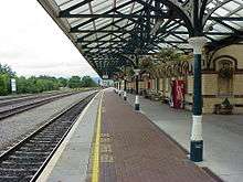 Dundalk railway station
 Dundalk IT.
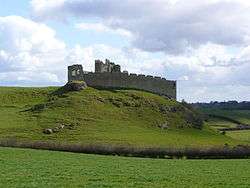 Castle Roche
 Slive Foy and King John's Castle
 Mellifont Abbey
 Dromiskin Round Tower
.jpg) Drogheda
Drogheda Drogheda railway station with the Enterprise
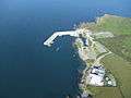 Clogherhead Harbour
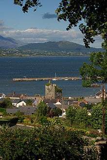 Carlingford Harbour
Freedom of the County
The Following People and Military Units have received the Freedom of County Louth.
- Joseph R. Biden Jr.: 2 July 2016. [27]
See also
- List of abbeys and priories in Ireland (County Louth)
- List of Castles in Louth
- Lord Lieutenant of Louth
- High Sheriff of Louth
- List of songs about Louth
References
- "Irish Chiefs and Clans in County Louth - Irish Pedigrees". www.libraryireland.com.
- "County Louth, Ireland Genealogy Genealogy - FamilySearch Wiki". www.familysearch.org.
- "Census 2016 Sapmap Area: County Louth". Central Statistics Office. 2016. Retrieved 21 July 2017.
- Pointon, Graham E. (1990). BBC Pronouncing Dictionary of British Names (2nd ed.). Oxford: Oxford University Press. p. 154. ISBN 0-19-282745-6.
- "Placenames Database of Ireland". Fiontar (DCU) and The Placenames Branch (Department of Arts, Heritage and the Gaeltacht). 2008. Retrieved 28 February 2014.
- Section 2(1) of the Local Government Act, 2001, provides that the administrative area for which a county council is responsible is a county: http://www.environ.ie/en/LocalGovernment/LocalGovernmentAdministration/RHLegislation/FileDownLoad,1963,en.pdf Archived 20 March 2012 at the Wayback Machine
- "North West Passage". northwestpassage.org. Retrieved 20 March 2018.
- Corry, Eoghan (2005). The GAA Book of Lists. Hodder Headline Ireland. pp. 186–191. ISBN 0-340-89695-7.
- Johnston, L. C. (1826). History of Drogheda: from the earliest period to the present time. Drogheda. p. 37.
- D'Alton, John 1844, The History of Drogheda
- "Archived copy". Archived from the original on 30 July 2014. Retrieved 15 September 2014.CS1 maint: archived copy as title (link)
- For 1653 and 1659 figures from Civil Survey Census of those years, Paper of Mr Hardinge to Royal Irish Academy 14 March 1865.
- "Server Error 404 - CSO - Central Statistics Office". www.cso.ie. Retrieved 20 March 2018.
- "HISTPOP.ORG - Home". www.histpop.org. Archived from the original on 7 May 2016.
- NISRA - Northern Ireland Statistics and Research Agency (c) 2013 Archived 17 February 2012 at the Wayback Machine. Nisranew.nisra.gov.uk (27 September 2010). Retrieved on 2013-07-23.
- Lee, JJ (1981). "On the accuracy of the Pre-famine Irish censuses". In Goldstrom, J. M.; Clarkson, L. A. (eds.). Irish Population, Economy, and Society: Essays in Honour of the Late K. H. Connell. Oxford, England: Clarendon Press.
- Mokyr, Joel; O Grada, Cormac (November 1984). "New Developments in Irish Population History, 1700-1850". The Economic History Review. 37 (4): 473–488. doi:10.1111/j.1468-0289.1984.tb00344.x. hdl:10197/1406. Archived from the original on 4 December 2012.
- "Legal Towns Dundalk Legal Town (CSO Area Code LT 10008)". Central Statistics Office. 2011.
- "Dundalk Legal Town And Its Environs Results". Central Statistics Office. 2011. Archived from the original on 29 October 2014.
- "Legal Towns Drogheda Legal Town (CSO Area Code LT 10008)". Central Statistics Office. 2011.
- "Drogheda Legal Town And Its Environs Results". Central Statistics Office. 2011. Archived from the original on 14 July 2014.
- "Dundalk Migration, Ethnicity and Religion (CSO Area Code LT 10008)". Central Statistics Office. 2011. Archived from the original on 29 October 2014.
- "Services". Louth County Council. Retrieved 31 March 2011.
- http://www.constituency-commission.ie/docs%5Ccon2007.pdfThis%5B%5D
- "Archived copy" (PDF). Archived from the original (PDF) on 12 August 2011. Retrieved 25 June 2014.CS1 maint: archived copy as title (link)
- "The Doegen Records Web Project". Doegen. Royal Irish Academy. 2009. Retrieved 13 October 2018.
- https://www.independent.ie/regionals/argus/news/biden-awarded-the-honorary-freedom-of-louth-34840788.html
External links
| Wikimedia Commons has media related to County Louth. |
| Wikivoyage has a travel guide for County Louth. |
- Carlingford town local site
- Drogheda Tourism - Official Site of the Drogheda Tourist Office
- Dunleer town portal
- Dunleer Parish
- Louth Local Authorities
- Omeath town local site
- Tallanstown Tidy Towns
- CSO Louth
Places adjacent to County Louth | ||||||||||
|---|---|---|---|---|---|---|---|---|---|---|
| ||||||||||
Places in County Louth | ||
|---|---|---|
| Towns | | |
| Villages and Townlands | ||
| ||
The counties are listed per province | ||
 | ||
| ||
| Authority control |
|
|---|