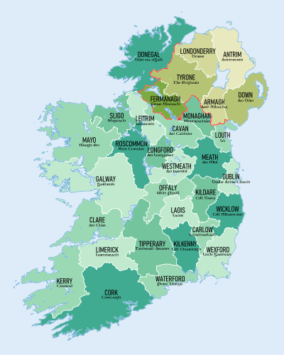
County Fermanagh
County Fermanagh (/fərˈmænə/ fər-MAN-ə; from Irish: Fir Manach or Fear Manach, meaning "men of Manach") is one of the thirty-two counties of Ireland and one of the six counties of Northern Ireland. The county covers an area of 1,691 km² (653 sq mi) and has a population of 61,805 as of 2011.[5] Enniskillen is the county town and largest in both size and population.
County Fermanagh Contae Fhear Manach Coontie Fermanagh | |
|---|---|
 Coat of arms | |
| Nickname(s): The Lakeland County | |
| Motto(s): | |
 | |
| Country | United Kingdom |
| Region | Northern Ireland |
| Province | Ulster |
| Established | 1584/85 |
| County town | Enniskillen |
| Area | |
| • Total | 715 sq mi (1,851 km2) |
| • Land | 653 sq mi (1,691 km2) |
| Area rank | 25th |
| Highest elevation (Cuilcagh) | 2,182 ft (665 m) |
| Population (est. 2011) | 61,805 |
| • Rank | 28th[1] |
| Time zone | UTC±0 (GMT) |
| • Summer (DST) | UTC+1 (BST) |
| Postcode area | |
| Website | discovernorthernireland |
| Contae Fhear Manach is the Irish name; Countie Fermanagh,[2] Coontie Fermanagh[3] and Coontie Fermanay[4] are Ulster Scots spellings (the latter used only by Dungannon & South Tyrone Borough Council). | |
Fermanagh is one of four counties of Northern Ireland to have a majority of its population from a Catholic background, according to the 2011 census.
Geography


Fermanagh is by far the least populous of Northern's Ireland's six counties, with just over one-third of the population of Northern Ireland's second least populous county, Armagh. It is the second smallest county in Northern Ireland by area and is ranked 25th in Ireland by size. Fermanagh borders County Tyrone to the north-east, County Monaghan to the south-east, County Cavan to the south-west, County Leitrim to the west and County Donegal to the north-west. The county town, Enniskillen, is the largest settlement in Fermanagh, situated in the middle of the county.
It is mainly rural, with a population density of 36.1 people per km2, and is situated largely in the basin of the River Erne. It is dominated by two connected lakes: Upper and Lower Lough Erne, and, including water, spans an area of 1,851 km² (715 sq; mi).[6] It is approximately 120 km (75 mi) from Belfast and 160 km (99 mi) from Dublin.
In the Köppen climate classification, Fermanagh experiences a temperate oceanic climate (Cfb') with cool winters, mild humid summers, and a lack of temperature extremes. Fermanagh accounts for 13.2% of the land mass of Northern Ireland and 30% of Fermanagh is covered with lakes and waterways. With 24,000 hectares of forest cover, or approximately 14% of total land area, Fermanagh is well above both the UK and Irish national averages. Due to its expansive lakelands and scenic rural countryside, much of the county is set to be designated an Area of Outstanding Natural Beauty.
Geology
The county is situated over a sequence of prominent faults, primarily the Killadeas – Seskinore Fault, the Tempo – Sixmilecross Fault, the Belcoo Fault and the Clogher Valley Fault which cross-cuts Lough Erne. To the north of Lough Erne, the oldest rocks in the county are found. These are red beds that were formed approximately 550 million years ago. In eastern Fermanagh there are extensive sandstones that were laid down during the Devonian, 400 million years ago. Much of the rest of the county's bedrock geology dates from the Carboniferous, 354 to 298 million years ago. These rocks are primarily marine muds, shales and limestones, which have produced extensive cave systems such as the Shannon Cave, the Marble Arch Caves and the Caves of the Tullybrack and Belmore hills. These carboniferous shales aggregate across several counties in the northwest of Ireland - known colloquially as the Lough Allen basin - and are estimated to contain 9.4 trillion cubic metres of natural gas, equivalent to 1.5 billion barrels of oil (approximately $115 billion at 2018 prices).[7]
The county has three prominent upland areas, the expansive West Fermanagh Scarplands to the southwest of Lough Erne, which rise to some 350m, the Sliabh Beagh hills to the east on the Monaghan border, and the Cuilcagh mountain range along Fermanagh's southern border, which contain Cuilcagh, the county's highest point, at 665m.
History
The Menapii are the only known Celtic tribe specifically named on Ptolemy’s 150 AD map of Ireland, where they located their first colony—Menapia—on the Leinster coast circa 216 BC. They later settled around Lough Erne, becoming known as the Fir Manach, and giving their name to Fermanagh and Monaghan. Mongán mac Fiachnai, a 7th-century King of Ulster, is the protagonist of several legends linking him with Manannán mac Lir. They spread across Ireland, evolving into historic Irish (also Scottish and Manx) clans.
The Annals of Ulster which cover medieval Ireland between AD 431 to AD 1540 were written at Belle Isle on Lough Erne near Lisbellaw.
Fermanagh was a stronghold of the Maguire clan and Donn Carrach Maguire (died 1302) was the first of the chiefs of the Maguire dynasty. However, on the confiscation of lands relating to Hugh Maguire, Fermanagh was divided in similar manner to the other five escheated counties among Scottish and English undertakers and native Irish. The baronies of Knockninny and Magheraboy were allotted to Scottish undertakers, those of Clankelly, Magherastephana and Lurg to English undertakers and those of Clanawley, Coole, and Tyrkennedy, to servitors and natives. The chief families to benefit under the new settlement were the families of Cole, Blennerhasset, Butler, Hume, and Dunbar.
Fermanagh was made into a county by statute of Elizabeth I, but it was not until the time of the Plantation of Ulster that it was finally brought under civil government.
The closure of all the lines of Great Northern Railway (Ireland) within County Fermanagh in 1957 left the county as the first non-island county in the UK without a railway service.
Administration
| Historical population | ||
|---|---|---|
| Year | Pop. | ±% |
| 1653 | 5,498 | — |
| 1659 | 7,102 | +29.2% |
| 1821 | 130,997 | +1744.5% |
| 1831 | 149,763 | +14.3% |
| 1841 | 156,481 | +4.5% |
| 1851 | 116,047 | −25.8% |
| 1861 | 105,768 | −8.9% |
| 1871 | 92,794 | −12.3% |
| 1881 | 84,879 | −8.5% |
| 1891 | 74,170 | −12.6% |
| 1901 | 65,430 | −11.8% |
| 1911 | 61,836 | −5.5% |
| 1926 | 57,984 | −6.2% |
| 1937 | 54,569 | −5.9% |
| 1951 | 53,044 | −2.8% |
| 1961 | 51,531 | −2.9% |
| 1966 | 49,886 | −3.2% |
| 1971 | 50,255 | +0.7% |
| 1981 | 51,594 | +2.7% |
| 1991 | 54,033 | +4.7% |
| 2001 | 57,527 | +6.5% |
| 2011 | 61,170 | +6.3% |
| [8][9][10][11][12][13] | ||
The county was administered by Fermanagh County Council from 1899 until the abolition of county councils in Northern Ireland in 1973.[14] With the creation of Northern Ireland's district councils, Fermanagh District Council the only one of the 26 that contained all of the county from which it derived its name. After the re-organisation of local government in 2015, Fermanagh was still the only county wholly within one council area, namely Fermanagh and Omagh District Council, albeit that it constituted only a part of that entity.
For the purposes of elections to the UK Parliament, the territory of Fermanagh is part of the Fermanagh and South Tyrone Parliamentary Constituency. This constituency elected Provisional IRA hunger-striker Bobby Sands as a member of parliament in the April 1981 Fermanagh and South Tyrone by-election, shortly before his death.
Industry and tourism
Agriculture and tourism are two of the most important industries in Fermanagh. The main types of farming in the area are beef, dairy, sheep, pigs and some poultry. Most of the agricultural land is used as grassland for grazing and silage or hay rather than for other crops.
The waterways are extensively used by cabin cruisers, other small pleasure craft and anglers. The main town of Fermanagh is Enniskillen (Inis Ceithleann, 'Ceithleann's island'). The island town hosts a range of attractions including the Castle Coole Estate and Enniskillen Castle, which is home to the museum of The Royal Inniskilling Fusiliers and the 5th Royal Inniskilling Dragoon Guards. Fermanagh is also home to The Boatyard Distillery, a distillery producing gin.
Attractions outside Enniskillen include:
- Belleek Pottery
- Castle Archdale
- Crom Estate
- Devenish Island
- Florence Court
- Marble Arch Caves
- Tempo Manor
- Cuilcagh Boardwalk Trail
Settlements
Villages
(population of 1,000 or more and under 2,250 at 2001 Census)[15]
Small villages or hamlets
(population of less than 1,000 at 2001 Census)[15]
Subdivisions
Baronies

Parishes
Townlands
Sport
Fermanagh GAA has never won a Senior Provincial or an All-Ireland title in any Gaelic games.
Only Ballinamallard United F.C. take part in the Northern Ireland football league system. All other Fermanagh clubs play in the Fermanagh & Western FA league systems. Fermanagh Mallards F.C. played in the Women's Premier League until 2013.
Enniskillen RFC was founded in 1925 and is still going.[16] There is also a rugby league team, the Fermanagh Redskins
Famous football players from Fermanagh include -
Notable people
Famous people born, raised in or living in Fermanagh include:
- John Armstrong (1717–1795), born in Fermanagh, Major General in the Continental Army and delegate in the Continental Congress[17]
- Samuel Beckett (1906–1989), author and playwright from Foxrock in Dublin, educated at Portora Royal School
- The 1st Viscount Brookeborough, Prime Minister of Northern Ireland, 1943-1963
- Denis Parsons Burkitt (1911–1993), doctor, discoverer of Burkitt's lymphoma
- Roy Carroll (born 1977), association footballer
- Edward Cooney (1867–1960), evangelist and early leader of the Cooneyite and Go-Preachers
- Brian D'Arcy (born 1945), C.P., Passionist priest and media personality
- Brendan Dolan (born 1973), professional darts player for the PDC
- Adrian Dunbar (born 1958), actor
- Arlene Foster (born 1970), politician
- Neil Hannon (born 1970), musician
- Sean Hoy (born 1964), Irish diplomat
- Robert Kerr (1882–1963), athlete and Olympic gold medalist
- Kyle Lafferty (born 1987), Northern Ireland International association footballer
- Charles Lawson (born 1959), actor (plays Jim McDonald in Coronation Street)
- Francis Little (1822–1890), born in Fermanagh, Wisconsin State Senator
- Terence MacManus (c. 1823–1861), leader in Young Irelander Rebellion of 1848
- Michael Magner (1840–97), recipient of the Victoria Cross
- Peter McGinnity, Gaelic footballer, Fermanagh's first winner of an All Star Award
- Martin McGrath, Gaelic footballer, All Star winner
- Ciarán McMenamin (born 1975), actor
- Barry Owens, Gaelic footballer, two time All Star winner
- Sean Quinn (born 1947), entrepreneur
- Michael Sleavon (1826–1902), recipient of the Victoria Cross
- Patrick Treacy, author and one time physician to Michael Jackson
- Joan Trimble (1915–2000), pianist and composer
- Oscar Wilde (1854–1900), author and playwright, educated at Portora Royal School
- Gordon Wilson (1927–1995), peace campaigner and Irish senator
Surnames
The most common surnames in County Fermanagh at the time of the United Kingdom Census of 1901 were:[18]
Railways
The railway lines in County Fermanagh connected Enniskillen railway station with Derry from 1854, Dundalk from 1861, Bundoran from 1868 and Sligo from 1882.[19]
The railway companies that served the county, prior to the establishment by merger of Londonderry and Enniskillen Railway, Enniskillen and Bundoran Railway the Dundalk and Enniskillen Railway which was later named the Irish North Western Railway, thus forming the Great Northern Railway (Ireland). By 1883 the Great Northern Railway (Ireland) absorbed all the lines except the Sligo, Leitrim and Northern Counties Railway, which remained independent throughout its existence.
In October 1957 the Government of Northern Ireland closed the GNR line, which made it impossible for the SL&NCR continue and forced it also to close.[20]
The nearest railway station to Enniskillen is Sligo station which is served by trains to Dublin Connolly and is operated by Iarnród Éireann. The Dublin-Sligo railway line has a two hourly service run by Irish Rail Official site – Timetables, bookings and operations The connecting bus from Sligo via Manorhamilton to Enniskillen is route 66 operated by Bus Éireann.
See also
| Wikimedia Commons has media related to County Fermanagh. |
- Abbeys and priories in Northern Ireland (County Fermanagh)
- Castles in County Fermanagh
- Extreme points of the United Kingdom
- High Sheriff of Fermanagh
- List of parishes of County Fermanagh
- List of places in County Fermanagh
- List of townlands in County Fermanagh
- Lord Lieutenant of Fermanagh
- People from County Fermanagh
Notes
- "Background Information on Northern Ireland Society – Population and Vital Statistics". Cain.ulst.ac.uk. Retrieved 20 October 2012.
- "North-South Ministerial Council: 2004 Annual Report in Ulster Scots" (PDF). Northsouthministerialcouncil.org. Archived from the original (PDF) on 2 September 2012. Retrieved 20 October 2012.
- "Tourism Ireland: Yierly Report 2007". Tourismireland.com. Archived from the original on 17 July 2012. Retrieved 20 October 2012.
- "Dungannon & South Tyrone Borough Council". Dungannon.gov.uk. Archived from the original on 8 April 2013. Retrieved 20 October 2012.
- "Archived copy". Archived from the original on 8 July 2015. Retrieved 2015-07-06.CS1 maint: archived copy as title (link)
- "County Fermanagh - definition of County Fermanagh by The Free Dictionary". Thefreedictionary.com. Retrieved 17 August 2016.
- "What's your fracking problem?". The Irish Times.
- For 1653 and 1659 figures from Civil Survey Census of those years, Paper of Mr Hardinge to Royal Irish Academy 14 March 1865.
- "Central Statistics Office: 2011 Census". Cso.ie. Retrieved 20 October 2012.
- "Histpop – The Online Historical Population Reports Website". Histpop.org. Archived from the original on 7 May 2016. Retrieved 20 October 2012.
- "NISRA – Northern Ireland Statistics and Research Agency". Nisranew.nisra.gov.uk. Archived from the original on 17 February 2012. Retrieved 20 October 2012.
- Lee, JJ (1981). "On the accuracy of the Pre-famine Irish censuses". In Goldstrom, J. M.; Clarkson, L. A. (eds.). Irish Population, Economy, and Society: Essays in Honour of the Late K. H. Connell. Oxford, England: Clarendon Press.
- Mokyr, Joel; O Grada, Cormac (November 1984). "New Developments in Irish Population History, 1700–1850". The Economic History Review. 37 (4): 473–488. doi:10.1111/j.1468-0289.1984.tb00344.x. hdl:10197/1406. Archived from the original on 4 December 2012.
- "Local Government Act (Northern Ireland) 1972". Legislation.gov.uk. Retrieved 29 November 2019.
- "Statistical classification of settlements". NI Neighbourhood Information Service. Archived from the original on 17 February 2010. Retrieved 23 February 2009.
- "StackPath". www.enniskillenrfc.com.
- Who Was Who in America, Historical Volume, 1607–1896. Chicago: Marquis Who's Who. 1963.
- "Fermanagh Genealogy Resources & Parish Registers | Ulster". Forebears.co.uk. Retrieved 17 August 2016.
- Hajducki, S. Maxwell (1974). A Railway Atlas of Ireland. Newton Abbott: David & Charles. maps 6, 7, 12. ISBN 0-7153-5167-2.
- Sprinks, N.W. (1970). Sligo, Leitrim and Northern Counties Railway. Billericay: Irish Railway Record Society (London Area).
References
- Clogher Record
- "Fermanagh" A Dictionary of British Place-Names. A. D. Mills. Oxford University Press, 2003. Oxford Reference Online. Oxford University Press. Northern Ireland Public Libraries. 25 July 2007
- "Fermanagh" Encyclopædia Britannica. 2007. Encyclopædia Britannica Online Library Edition. 25 July 2007 <Britannica Library>.
- Fermanagh: its special landscapes: a study of the Fermanagh countryside and its heritage /Department of the Environment for Northern Ireland. – Belfast: HMSO, 1991 ISBN 0-337-08276-6
- Livingstone, Peadar. – The Fermanagh story:a documented history of the County Fermanagh from the earliest times to the present day – Enniskillen: Cumann Seanchais Chlochair, 1969.
- Lowe, Henry N. – County Fermanagh 100 years ago: a guide and directory 1880. – Belfast: Friar's Bush Press, 1990. ISBN 0-946872-29-5
- Parke, William K. – A Fermanagh Childhood. Derrygonnelly, Co Fermanagh: Friar's Bush Press, 1988. ISBN 0-946872-12-0
- Impartial Reporter
- Fermanagh Herald
External links
| Wikimedia Commons has media related to County Fermanagh. |
| Wikivoyage has a travel guide for County Fermanagh. |
Places adjacent to County Fermanagh | ||||||||||
|---|---|---|---|---|---|---|---|---|---|---|
| ||||||||||
The counties are listed per province | ||
 | ||
| ||
| Authority control |
|
|---|