Dursey Island
Dursey Island (Irish: Baoi Bhéarra or Oileán Baoi[2]) lies at the southwestern tip of the Beara Peninsula in the west of County Cork in Ireland. Dursey Island is 6.5 kilometres long and 1.5 kilometres wide. The island is separated from the mainland by a narrow stretch of water, Dursey Sound, which has a very strong tidal race, with the submerged Flag Rock close to the centre of the channel. The island has just six or so permanent residents, and is connected to the mainland by Ireland's only cable car. Dursey has no shops, pubs or restaurants.[3] At one point there was a post office on the island; this has since closed. [2][4]
| Native name: Oileán Baoi | |
|---|---|
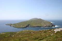 Dursey Island as seen from a hiking path on the mainland | |
 Dursey Island | |
| Geography | |
| Location | Beara Peninsula |
| Coordinates | 51°36′N 10°12′W |
| Area | 5.6 km2 (2.2 sq mi) |
| Length | 6.5 km (4.04 mi) |
| Width | 1.5 km (0.93 mi) |
| Highest elevation | 252 m (827 ft) |
| Administration | |
Ireland | |
| Province | Munster |
| County | Cork |
| Demographics | |
| Population | 4 (2016)[1] |
| Additional information | |
| Official website | DurseyIsland.ie |
Geography and fauna
The townlands on the island are Ballynacallagh, Kilmichael, and Tilickafinna. There are three main peaks, the highest 252m.[5] The promontories and rocks off Dursey include:
Bull Rock
Off the western point of the island are three rocks: Bull Rock, Cow Rock and Calf Rock. On Bull Rock in a tidal race stands a lighthouse built in 1888 and automated in March 1991. This island was inhabited until this time.[6]
| Historical population (Bull Rock) | ||||||||||||||||||||||||||||||||||||||||||||||||||||||||||||||||||||||||||||||||
|---|---|---|---|---|---|---|---|---|---|---|---|---|---|---|---|---|---|---|---|---|---|---|---|---|---|---|---|---|---|---|---|---|---|---|---|---|---|---|---|---|---|---|---|---|---|---|---|---|---|---|---|---|---|---|---|---|---|---|---|---|---|---|---|---|---|---|---|---|---|---|---|---|---|---|---|---|---|---|---|---|
|
|
| ||||||||||||||||||||||||||||||||||||||||||||||||||||||||||||||||||||||||||||||
| Source: Central Statistics Office. "CNA17: Population by Off Shore Island, Sex and Year". CSO.ie. Retrieved October 12, 2016. | ||||||||||||||||||||||||||||||||||||||||||||||||||||||||||||||||||||||||||||||||
Calf Rock
A manned lighthouse on Calf Rock was destroyed in a storm in 1881 and its remains can still be seen.[7]
Cow Rock
Cow Rock is home to a number of nesting colonies of seabirds. Dolphins, whales and basking shark are sometimes seen in the sea off the island.
History
Prehistoric sites have been surveyed on the island, including examples of bullaun and cup-marked stones in Ballynacallagh, a prehistoric hut site at Killowen, and a radial stone enclosure at Maughanaclea.[8]
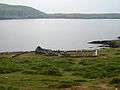
More prominent archaeological sites are visible at Ballynacallagh, where there is a ruined monastic church and graveyard, and at the site of a castle on Oileán Beag ("Small Island"). In 1602 this castle site was a garrison of the O'Sullivan Beare family. It was destroyed (along with Dunboy Castle) during the Nine Years' War. Philip O'Sullivan Beare documents that all of the occupants of the castle were killed by the English in the Dursey Massacre.[9] The 300 islanders were killed; Donal Cam O'Sullivan Beare gathered his people from across Cork and set off to take shelter with the O'Rourkes of Leitrim. Of the 1,000 that set off, 35 survived to reach the O'Rourkes after the convoy was repeatedly attacked.[5] Little evidence of the castle site remains.
On the highest point on the island, at Tilickafinna, is a signal tower dating to the Napoleonic Wars.[10] This narrow rectangular tower had two storeys over a basement, with each storey supported by vaulted stonework. The tower has been in ruin since the mid-19th century.[11]
During World War II a whitewashed sign saying "Éire" was built and painted close to the signal tower to indicate to pilots that they were overflying neutral Ireland. In July 1943 a Luftwaffe Junkers Ju 88 crashed on Crow Head near Dursey, killing all crew.[12]
| Historical population | ||||||||||||||||||||||||||||||||||||||||||||||||||||||||||||||||||||||||||||||||||||||
|---|---|---|---|---|---|---|---|---|---|---|---|---|---|---|---|---|---|---|---|---|---|---|---|---|---|---|---|---|---|---|---|---|---|---|---|---|---|---|---|---|---|---|---|---|---|---|---|---|---|---|---|---|---|---|---|---|---|---|---|---|---|---|---|---|---|---|---|---|---|---|---|---|---|---|---|---|---|---|---|---|---|---|---|---|---|---|
|
|
| ||||||||||||||||||||||||||||||||||||||||||||||||||||||||||||||||||||||||||||||||||||
| Source: Central Statistics Office. "CNA17: Population by Off Shore Island, Sex and Year". CSO.ie. Retrieved October 12, 2016. and "E2021: Population of Inhabited Islands Off the Coast 2011 to 2016 by Sex, Islands and Census Year". | ||||||||||||||||||||||||||||||||||||||||||||||||||||||||||||||||||||||||||||||||||||||
Tourism
The island is popular with day-trippers and walkers during the summer months. A waymarked section of the Beara Way loops around the island.[13] Dursey Island's Beara Way walk marks the beginning of Europe's E8 European long distance path, which crosses Europe, ending in Istanbul, Turkey.
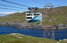
Spanning Dursey Sound, the aerial tramway is Ireland's only cable car,[14] and one of the few cable cars that cross the sea in Europe. It is one of the island's main attractions for tourists, as well as serving the local population.[15]
Dursey Sound is also one of the "signature discovery points" along the Wild Atlantic Way[16] - a coastal touring route that stretches along Ireland's Atlantic coastline. On one road there is a 100 km/h speed limit sign – probably placed as a prank.[17]
Dursey has no shops, pubs or restaurants, but a few holiday homes are rented on the island.[18]
Gallery
 Ecclesiastical ruins and graveyard at Ballynacallagh
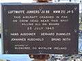 JU88 memorial sign on mainland next to Dursey cable car
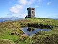 Napoleonic era signal tower
%2C_Standing_stone_-_geograph.org.uk_-_284000.jpg) Standing stones
Standing stones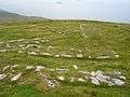 Remains of World War II "EIRE" neutrality sign
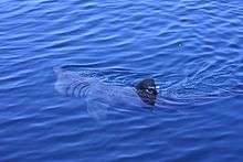 A basking shark feeds in the Dursey Sound.
| Wikimedia Commons has media related to Dursey Island. |
References
- "E2021: Population of Inhabited Islands Off the Coast 2011 to 2016 by Sex, Islands and Census Year". Census 2016. Central Statistics Office. 2016. Retrieved 13 August 2018.
- Logainm - Dursey
- "Dursey Island - Home". Durseyisland.ie. Retrieved 2014-07-28.
- West Cork and Kerry website
- Enright, Damien (2013-08-26). "Cork: Tracing Dursey Island's history". Irish Examiner. Retrieved 2014-07-28.
- "Lighthouses > Bull Rock". CommissionerOfIrishLights.com. Archived from the original on 1 January 2013.
- "Beam Magazine - Volume 36 - The Calf Rock Disaster". commissionersofirishlights.com. Archived from the original on 20 August 2013.
- Penelope Durell (1996). Discover Dursey. Ballinacarriga Books. p. 14.
- Timothy Daniel Sullivan (1908). Bantry, Berehaven and the O'Sullivan Sept. Sealy, Bryers & Walker. p. 20. Retrieved 2014-07-28.
- Samuel Lewis (1837). Topographical Dictionary of Ireland. Retrieved 2014-07-28.
- "The Signal Tower On Dursey Island". Mutantspace. Retrieved 2014-07-28.
- See memorial sign at cable-car crossing
- "Dursey Island Loop - Looped Walks". Discoverireland.ie. Retrieved 2014-07-28.
- http://www.durseyisland.ie/cable-car-timetable.html
- "Cable Car Timetable - Dursey Island". Durseyisland.ie. 2014-06-14. Retrieved 2014-07-28.
- "Dursey Island - Wild Atlantic Way - Signature Point - Discover Ireland". Discoverireland.ie. Retrieved 23 August 2014.
- Flickr Mozzercork
- "Dursey Island Tourism Information". Discoverireland.ie. Retrieved 2014-07-28.