Black Point-Green Point, California
Black Point-Green Point is a census-designated place (CDP) in Marin County, California, United States. The population was 1,306 at the 2010 census.
Black Point-Green Point | |
|---|---|
 Location in Marin County and the state of California | |
 Black Point-Green Point Location in the United States | |
| Coordinates: 38°6′35″N 122°30′13″W | |
| Country | |
| State | |
| County | Marin |
| Government | |
| • County Board | District 5 Judy Arnold |
| • Assembly | Marc Levine (D) |
| • U. S. Congress | Jared Huffman (D)[1] |
| Area | |
| • Total | 2.90 sq mi (7.50 km2) |
| • Land | 2.83 sq mi (7.32 km2) |
| • Water | 0.07 sq mi (0.18 km2) 0.44% |
| Population (2010) | |
| • Total | 3,879 |
| • Estimate (2016)[3] | N/A |
| Time zone | UTC-8 (PST) |
| • Summer (DST) | UTC-7 (PDT) |
| ZIP code | 94945 |
| Area codes | 415/628 |
| FIPS code | 06-06982 |
| GNIS feature IDs | 2407857 |
History
The first Black Point post office operated from 1865 to 1891.[4] The Grandview post office opened in 1905, changed its name to Black Point to 1944, and closed in 1952.[4]
Geography
According to the United States Census Bureau, the CDP has a total area of 2.7 square miles (7.0 km2), virtually all of it land.
Demographics
| Historical population | |||
|---|---|---|---|
| Census | Pop. | %± | |
| U.S. Decennial Census[5] | |||
2010
At the 2010 census Black Point-Green Point had a population of 1,306. The population density was 484.0 people per square mile (186.9/km²). The racial makeup of Black Point-Green Point was 1,185 (90.7%) White, 7 (0.5%) African American, 6 (0.5%) Native American, 45 (3.4%) Asian, 0 (0.0%) Pacific Islander, 28 (2.1%) from other races, and 35 (2.7%) from two or more races. Hispanic or Latino of any race were 112 people (8.6%).[6]
The census reported that 100% of the population lived in households.
There were 578 households, 109 (18.9%) had children under the age of 18 living in them, 315 (54.5%) were opposite-sex married couples living together, 30 (5.2%) had a female householder with no husband present, 22 (3.8%) had a male householder with no wife present. There were 45 (7.8%) unmarried opposite-sex partnerships, and 9 (1.6%) same-sex married couples or partnerships. 148 households (25.6%) were one person and 48 (8.3%) had someone living alone who was 65 or older. The average household size was 2.26. There were 367 families (63.5% of households); the average family size was 2.70.
The age distribution was 197 people (15.1%) under the age of 18, 69 people (5.3%) aged 18 to 24, 199 people (15.2%) aged 25 to 44, 550 people (42.1%) aged 45 to 64, and 291 people (22.3%) who were 65 or older. The median age was 53.2 years. For every 100 females, there were 94.6 males. For every 100 females age 18 and over, there were 93.9 males.
There were 615 housing units at an average density of 227.9 per square mile (88.0/km²), of which 79.9% were owner-occupied and 20.1% were occupied by renters. The homeowner vacancy rate was 0.6%; the rental vacancy rate was 4.9%. 83.5% of the population lived in owner-occupied housing units and 16.5% lived in rental housing units.
2000
At the 2000 census there were 1,143 people, 479 households, and 331 families in the CDP. The population density was 619.5 people per square mile (239.8/km²). There were 503 housing units at an average density of 272.6 per square mile (105.5/km²). The racial makeup of the CDP in 2010 was 85.5% non-Hispanic White, 0.5% non-Hispanic Black or African American, 0.3% Native American, 3.4% Asian, 0.2% from other races, and 1.6% from two or more races. 8.6% of the population were Hispanic or Latino of any race.[7] Of the 479 households 22.3% had children under the age of 18 living with them, 60.1% were married couples living together, 7.1% had a female householder with no husband present, and 30.7% were non-families. 21.5% of households were one person and 5.8% were one person aged 65 or older. The average household size was 2.39 and the average family size was 2.77.
The age distribution was 18.2% under the age of 18, 3.4% from 18 to 24, 22.6% from 25 to 44, 41.6% from 45 to 64, and 14.2% 65 or older. The median age was 47 years. For every 100 females, there were 89.6 males. For every 100 females age 18 and over, there were 94.4 males.
The median household income was $92,729 and the median family income was $104,531. Males had a median income of $76,782 versus $50,769 for females. The per capita income for the CDP was $52,372. About 1.9% of families and 2.9% of the population were below the poverty line, including 6.5% of those under age 18 and none of those age 65 or over.
References
- "California's 2nd Congressional District - Representatives & District Map". Civic Impulse, LLC. Retrieved March 8, 2013.
- "2016 U.S. Gazetteer Files". United States Census Bureau. Retrieved Jul 19, 2017.
- "Population and Housing Unit Estimates". Retrieved June 9, 2017.
- Durham, David L. (1998). California's Geographic Names: A Gazetteer of Historic and Modern Names of the State. Clovis, Calif.: Word Dancer Press. p. 603. ISBN 1-884995-14-4.
- "Census of Population and Housing". Census.gov. Retrieved June 4, 2016.
- "2010 Census Interactive Population Search: CA - Black Point-Green Point CDP". U.S. Census Bureau. Archived from the original on July 15, 2014. Retrieved July 12, 2014.
- "U.S. Census website". United States Census Bureau. Retrieved 2008-01-31.
Municipalities and communities of Marin County, California, United States | ||
|---|---|---|
| Cities and towns | 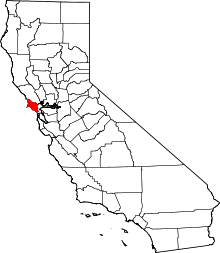 Marin County map | |
| CDPs | ||
| Unincorporated communities |
| |
| Ghost towns | ||
| Bodies of water |
|  |
|---|---|---|
| Counties | ||
| Major cities | ||
| Cities and towns 100k–250k | ||
| Cities and towns 50k–99k | ||
| Cities and towns 25k–50k | ||
| Cities and towns 10k–25k |
| |
| Sub-regions | ||