Al-Mas'udiyya
Al-Mas'udiyya (also known as Summayl), was a Palestinian Arab village in the Jaffa Subdistrict. It was depopulated during the 1947–1948 Civil War in Mandatory Palestine on December 25, 1947. It was located 5 km northeast of Jaffa, situated 1.5 km south of the al-'Awja River. The village used to be known as Summayl.
Al-Mas'udiyya المسعوديّة/صميل Summayl | |
|---|---|
Village | |
 Remains of Al-Mas'udiyya, in 2005. | |
| Etymology: Summeil, personal name, from "hard", or "withered"[1] | |
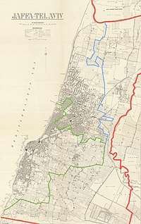 The village shown within the Jaffa municipality (thick red line) on a 1930 Survey of Palestine map; click image to view full map | |
 Al-Mas'udiyya The village shown within the Jaffa municipality (thick red line) on a 1930 Survey of Palestine map; click image to view full map | |
| Coordinates: 32°05′07″N 34°46′54″E | |
| Palestine grid | 129/165 |
| Geopolitical entity | Mandatory Palestine |
| Subdistrict | Jaffa |
| Date of depopulation | December 25, 1947[2] |
| Population (1945) | |
| • Total | 850[3][4] |
| Cause(s) of depopulation | Fear of being caught up in the fighting |
| Current Localities | part of Tel Aviv[5] |
History
In 1799, it was noted as an unnamed village on the map that Pierre Jacotin compiled that year.[6]
An Ottoman village list from about 1870 showed that Samwil had 23 houses and a population of 62, though the population count included men, only. It was noted as a Bedouin camp, 4,5 km north of Jaffa centre, and 1 km from the sea.[7][8]
In 1882, the PEF's Survey of Western Palestine (SWP) described Summeil as an ordinary adobe village,[9] which had a large well, and a cave.[10]
British Mandate era
In the 1922 census of Palestine, conducted by the British Mandate authorities, Mas'udiyeh had a population of 443; 437 Muslims and 6 Christians,[11] (where the Christians all belonged to the Templar community),[12] increasing in the 1931 census to 658; 654 Muslim and 4 Christians, in a total of 127 houses.[13]
In the 1945 statistics, the village had a population of 850; 830 Muslims and 20 Christians.[3][4]
Al-Mas'udiyya had an elementary school founded in 1931, and in 1945 it had 31 students.[5]
1948, aftermath
In 1992, the village site was described: "The area is part of Tel Aviv. All that remains of the village is one deserted house that belonged to Muhammad Baydas. Cactuses, castor-oil (ricinus) plants, and palm and cypress trees further mark the site. Nearby is the al-Mas'udiyya (or Summayl) bridge – an arched, steel structure."[5]
References
- Palmer, 1881, p. 219
- Morris, 2004, p. xviii, village #205. Also gives cause of depopulation.
- Department of Statistics, 1945, p. 27
- Government of Palestine, Department of Statistics. Village Statistics, April, 1945. Quoted in Hadawi, 1970, p. 52
- Khalidi, 1992, p. 249
- Karmon, 1960, p. 161
- Socin, 1879, p. 160
- Hartmann, 1883, p. 137 also noted 23 houses
- Conder and Kitchener, 1882, SWP II, p. 254
- Conder and Kitchener, 1882, SWP II, p. 275
- Barron, 1923, Table VII, Sub-district of Jaffa, p. 20
- Barron, 1923, Table XIV, p. 46
- Mills, 1932, p. 14
Bibliography
- Barron, J.B., ed. (1923). Palestine: Report and General Abstracts of the Census of 1922. Government of Palestine.
- Conder, C.R.; Kitchener, H.H. (1882). The Survey of Western Palestine: Memoirs of the Topography, Orography, Hydrography, and Archaeology. 2. London: Committee of the Palestine Exploration Fund.
- Department of Statistics (1945). Village Statistics, April, 1945. Government of Palestine.
- Hadawi, S. (1970). Village Statistics of 1945: A Classification of Land and Area ownership in Palestine. Palestine Liberation Organization Research Centre. Archived from the original on 2018-12-08. Retrieved 2009-08-18.
- Hartmann, M. (1883). "Die Ortschaftenliste des Liwa Jerusalem in dem türkischen Staatskalender für Syrien auf das Jahr 1288 der Flucht (1871)". Zeitschrift des Deutschen Palästina-Vereins. 6: 102–149.
- Karmon, Y. (1960). "An Analysis of Jacotin's Map of Palestine" (PDF). Israel Exploration Journal. 10 (3, 4): 155–173, 244–253.
- Khalidi, W. (1992). All That Remains: The Palestinian Villages Occupied and Depopulated by Israel in 1948. Washington D.C.: Institute for Palestine Studies. ISBN 0-88728-224-5.
- Mills, E., ed. (1932). Census of Palestine 1931. Population of Villages, Towns and Administrative Areas. Jerusalem: Government of Palestine.
- Morris, B. (2004). The Birth of the Palestinian Refugee Problem Revisited. Cambridge University Press. ISBN 978-0-521-00967-6. (pp. 91, 126, 128, 384)
- Palmer, E.H. (1881). The Survey of Western Palestine: Arabic and English Name Lists Collected During the Survey by Lieutenants Conder and Kitchener, R. E. Transliterated and Explained by E.H. Palmer. Committee of the Palestine Exploration Fund.
External links
- Welcome To al-Mas'udiyya
- al-Mas'udiyya (Summayl), Zochrot
- Survey of Western Palestine, Map 13: IAA, Wikimedia commons
- A Mosque Once Stood Here, Meron Rapoport Sep 16, 2005, Haaretz