Zhutian
Coordinates: 22°35′20″N 120°31′49″E / 22.588971°N 120.530266°E
| Zhutian Township 竹田鄉 | |
|---|---|
| Rural township | |
 | |
 Zhutian Township in Pingtung County | |
| Location | Pingtung County, Taiwan |
| Area | |
| • Total | 29 km2 (11 sq mi) |
| Population (July 2018) | |
| • Total | 17,209 |
| • Density | 590/km2 (1,500/sq mi) |
| Zhutian Township | |
| Traditional Chinese | 竹田鄉 |
|---|---|
| Literal meaning | bamboo field township |
| Hanyu Pinyin | Zhútián Xiāng |
| Wade–Giles | Chu2-t'ien2 Hsiang1 |
| Tongyong Pinyin | Jhútián Siang |
| Pha̍k-fa-sṳ | Tsuk-thièn-hiông |
| Hokkien POJ | Tek-chhân-hiong |
.jpg)
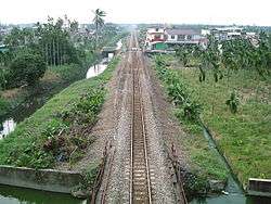
Zhutian Station
Zhutian Township,[1] also spelled Jhutian,[2] is a rural township in Pingtung County, Taiwan.
Geography
- Population: 17,719 people (December 2014)
- Area: 29.07 square kilometres (11.22 sq mi)
- Main ethic group: Hakka
Administrative divisions
The township comprises 15 villages:
- Dahu (大湖村)
- Erlun (二崙村)[3]
- Fengming (鳳明村)
- Futian (福田村)
- Liuxiang (六巷村)
- Lufeng (履豐村)
- Meilun (美崙村)
- Nanshi (南勢村)
- Sizhou (泗洲村)
- Tiaodi (糶糴村)
- Toulun (頭崙村)
- Xishi (西勢村)
- Yongfeng (永豐村)
- Zhunan (竹南村)
- Zhutian (竹田村)
Economy
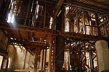
Rice factory in Zhutian
Zhutian is famous for its agricultural products.
Tourist attractions
Transportation
.jpg)
Zhutian Station
References
- ↑ 臺灣地區鄉鎮市區級以上行政區域名稱中英對照表 Archived March 25, 2012, at the Wayback Machine. Glossary of Names for Administrative Divisions. (in Chinese) Accessed at Taiwan Geographic Names Information System website Archived August 16, 2013, at the Wayback Machine. (in English). Ministry of the Interior. 16 June 2011. Retrieved 1 March 2015.
- ↑ 鄉鎮中英對照
- ↑ http://www.taipeitimes.com/News/lang/archives/2015/07/28/2003624023
External links
| Wikimedia Commons has media related to Jhutian Township, Pingtung. |
- Jhutian Township Office (in Chinese)
Cities and townships of Pingtung County | ||
|---|---|---|
| Cities | 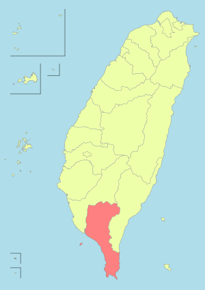 | |
| Urban townships | ||
| Rural townships | ||
| Mountain indigenous townships | ||
This article is issued from
Wikipedia.
The text is licensed under Creative Commons - Attribution - Sharealike.
Additional terms may apply for the media files.