Yavne'el
Yavne'el
| |
|---|---|
| Hebrew transcription(s) | |
| • ISO 259 | Yabnˀel |
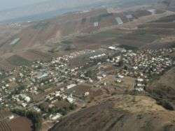 View of Yavne'el | |
 Yavne'el | |
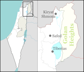
| Coordinates: 32°42′34″N 35°29′58″E / 32.70944°N 35.49944°ECoordinates: 32°42′34″N 35°29′58″E / 32.70944°N 35.49944°E | |
| Grid position | 197/234 PAL |
| District | Northern |
| Founded | 1901 |
| Government | |
| • Type | Local council (from 1951) |
| • Head of Municipality | Ronny Cohen |
| Area | |
| • Total | 31,680 dunams (31.68 km2 or 12.23 sq mi) |
| Population (2017)[1] | |
| • Total | 4,281 |
| • Density | 140/km2 (350/sq mi) |
Yavne'el (Hebrew: יַבְנְאֵל, Arabic: يفنيئيل) is a moshava and local council in the Northern District of Israel. It is one of the oldest rural Jewish communities in the country.[2] In 2017 it had a population of 4,281.
History
Remains from the Late Bronze Age,[3][4] Iron Age I–II,[3] Persian,[3] Hellenistic,[5] Roman,[3] and Late Byzantine[3][4][6] eras have been found here.
A residential building constructed in the Umayyad period that continued to be inhabited during the Abbasid period (eighth–tenth centuries CE) has been excavated here.[7]
Remains from the Mamluk era have also been found.[6][4]
Ottoman era
During the Ottoman era the Muslim village in the area was known as ‘’Yemma’’.[8] The village was mentioned in the Ottoman defter for the year 1555-6, located in the Nahiya of Tabariyya of the Liwa of Safad, with its land designated as Timar land.[9]
A map by Pierre Jacotin from Napoleon's invasion of 1799 noted the place.[10] In 1875 Victor Guérin visited, and described the village as rather ruined and built of basaltic stone, situated in a fertile valley.[11] In 1881, the Palestine Exploration Fund's Survey of Western Palestine (SWP) described Yemma as having basaltic stone houses, containing 100 Muslims, on an arable plain. There were no gardens or trees, but two springs were near, and the village had cisterns.[12] To the south-west of this site there was a supply of water among the rocks of the valley.[13]
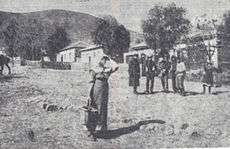
Yavne'el was established by the Jewish Colonization Association on lands bought by the Baron Rothschild, by villagers from Metula and from the Hauran region (Jewish settlers of the Hauran or "Horan" as it was called, had been evicted from there in 1898 by the Ottoman authorities).[14]
British Mandate era
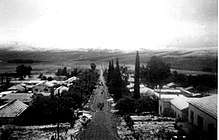
In the 1922 census of Palestine conducted by the British Mandate authorities, Yabnieh (Yamma) had a total population of 447; 82 Muslims and 365 Jews.[15] At the time of the 1931 census, Yavneel still had exactly the same population of 447; but now it was 56 Muslims and 391 Jews, in a total of 102 houses.[16]
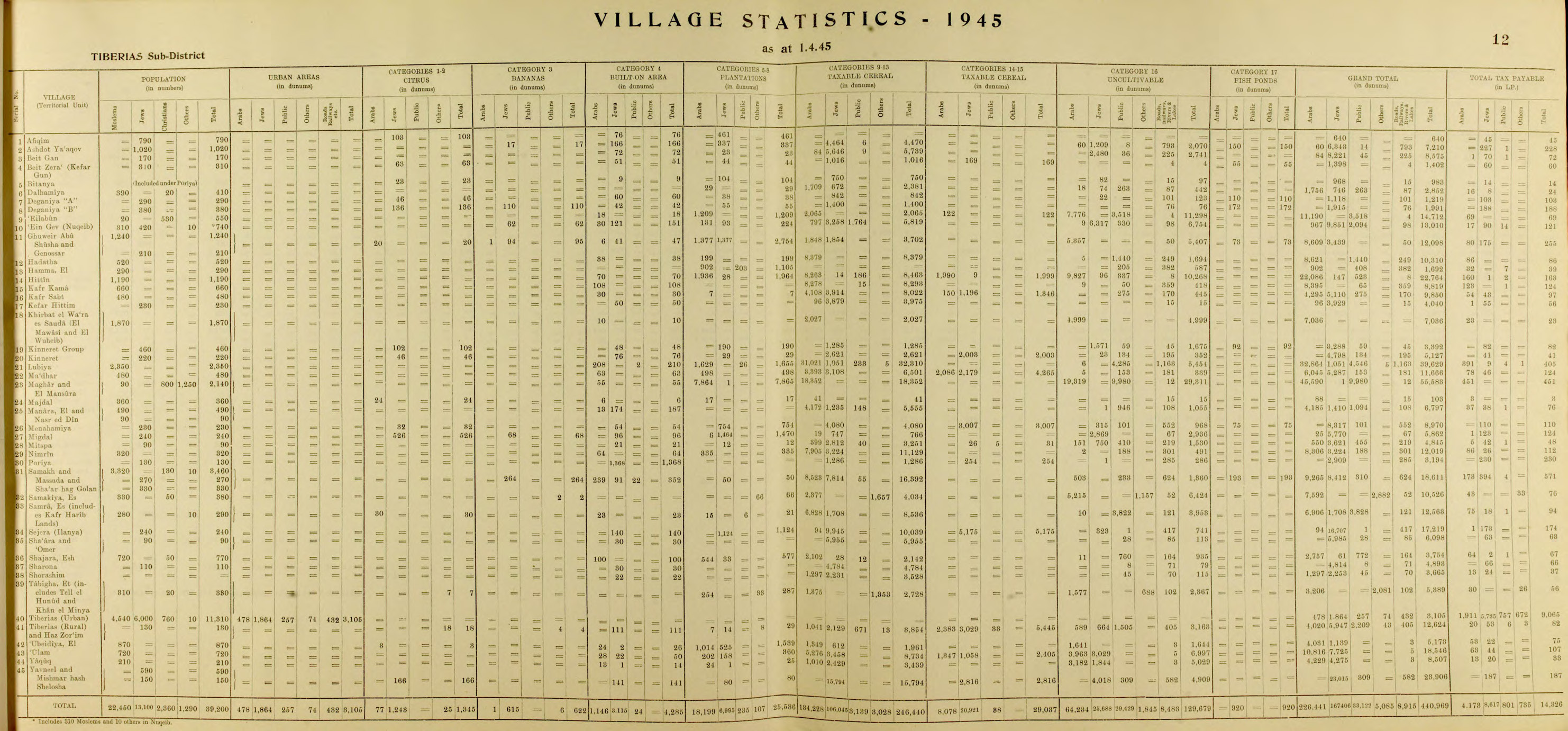
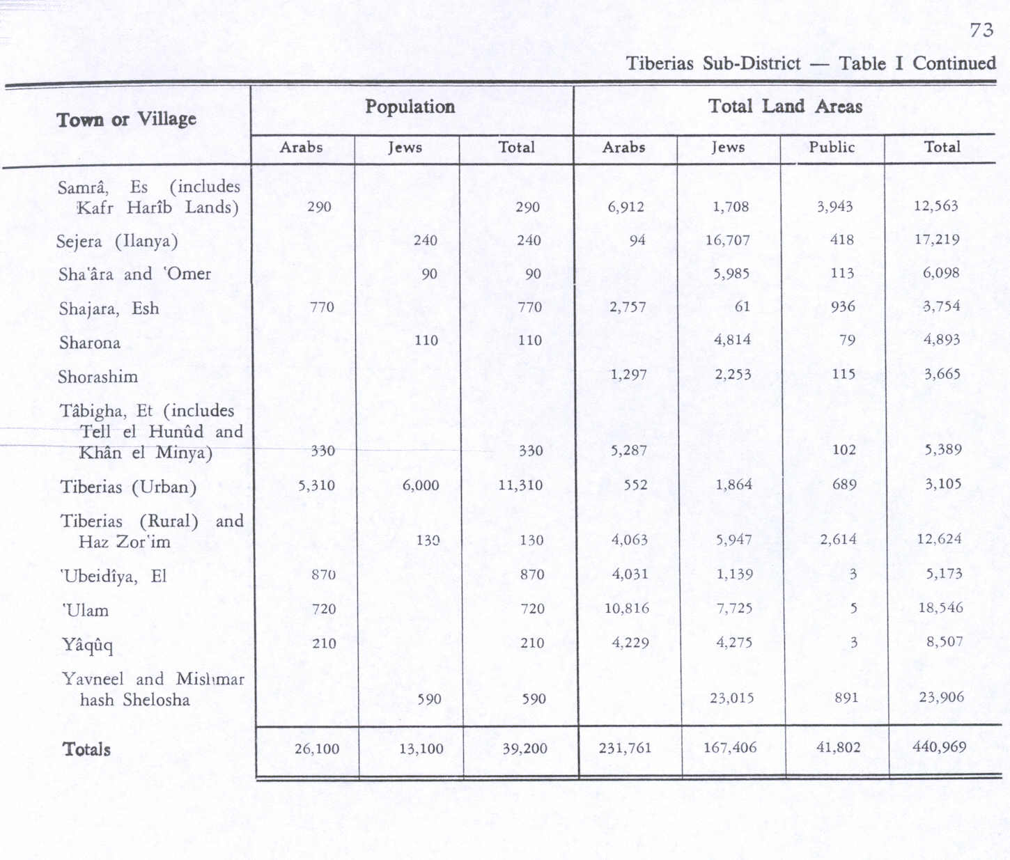
In the 1945 statistics, Yavneel was home to 590 people, all Jews.[17][18]
State of Israel
Located southwest of Tiberias, it was declared a local council in 1951. According to the Israel Central Bureau of Statistics (CBS), Yavne'el had a population of 3,100 in 2008, with a growth rate of 1.4%. The local council is jointly responsible for Yavne'el, Beit Gan, Mishmar HaShlosha, and Smadar. Many organizations were established in Yavne'el, including the Israeli Farmers Union, the Galilee Squadron and the Golani Brigade.
Breslov City
In 1986, Rabbi Eliezer Shlomo Schick founded a Breslov community largely consisting of baalei teshuvah (newly religious) adherents in Yavne'el. As of 2015 this community, which calls itself "Breslov City", numbers nearly 400 families, representing 30 percent of the town's population.[19] The community has its own educational and civic organizations, including a Talmud Torah, girls' school, yeshiva ketana, yeshiva gedola, kollel,[20] beis medrash (study/prayer hall), and charity and humanitarian organizations.[19]
Notable residents
- Ruth Amiran (1914–2005), Israeli archaeologist
- Keren Peles (born 1979), Israeli singer-songwriter and pianist
- Eliezer Shlomo Schick (1940–2015), Hasidic rabbi
References
- ↑ "List of localities, in Alphabetical order" (PDF). Israel Central Bureau of Statistics. Retrieved August 26, 2018.
- ↑ Tradition, Innovation, Conflict: Jewishness and Judaism in Contemporary Israel, ed. Zvi Sobel and Benjamin Beit-Hallahmi
- 1 2 3 4 5 Leibowitz 1995, cited in Hanna, 2017, Yavne’el
- 1 2 3 Brink, van den, 2017, Yavne’el, Tel Yin’am
- ↑ Dalali-Amos, 2011, Yavne’el, Bet Gan
- 1 2 Hanna, 2009, Yavne’el
- ↑ Hanna, 2017, Yavne’el
- ↑ from a personal name, according to Palmer, 1881, p. 138
- ↑ Rohde, 1979, p. 104
- ↑ Karmon, 1960, p. 167.
- ↑ Guérin, 1880, p. 268
- ↑ Conder and Kitchener, 1881, SWP I, p. 362
- ↑ Conder and Kitchener, 1881, SWP I, p. 379
- ↑ Ben-Porat, Amir (1991). "Immigration, proletarianization, and deproletarianization A case study of the Jewish working class in Palestine, 1882-1914". Theory and Society (20): 244.
- ↑ Barron, 1923, Table XI, Sub-District of Tiberius, p. 39
- ↑ Mills, 1932, p. 85
- ↑ Department of Statistics, 1945, p. 12
- ↑ Government of Palestine, Department of Statistics. Village Statistics, April, 1945. Quoted in Hadawi, 1970, p. 73
- 1 2 "Harav Eliezer Shlomo Shick, zt"l, of Yavne'el". Hamodia, Israel news, February 12, 2015, p. 9.
- ↑ Tzoren, Moshe Michael. "Away From the Hustle and Bustle of the Big City: Investors from Israel and abroad are buying up large lots in Yavniel, a quiet village in the Galilee, with an eye on building hundreds of housing units for the chareidi public". Hamodia Israel news, 23 December 2010, pp. A26-A27. Retrieved 29 January 2011.
Bibliography
- Barron, J. B., ed. (1923). Palestine: Report and General Abstracts of the Census of 1922. Government of Palestine.
- Brink, van den, Edwin C.M. (2017-12-04). "Yavne'el, Tel Yin'am" (129). Hadashot Arkheologiyot – Excavations and Surveys in Israel.
- Conder, C.R.; Kitchener, H.H. (1881). The Survey of Western Palestine: Memoirs of the Topography, Orography, Hydrography, and Archaeology. 1. London: Committee of the Palestine Exploration Fund.
- Dalali-Amos, Edna (2011-08-16). "Yavne'el" (123). Hadashot Arkheologiyot – Excavations and Surveys in Israel.
- Dalali-Amos, Edna (2011-12-19). "Yavne'el, Bet Gan" (123). Hadashot Arkheologiyot – Excavations and Surveys in Israel.
- Department of Statistics (1945). Village Statistics, April, 1945. Government of Palestine.
- Guérin, V. (1880). Description Géographique Historique et Archéologique de la Palestine (in French). 3: Galilee, pt. 1. Paris: L'Imprimerie Nationale.
- Hadawi, S. (1970). Village Statistics of 1945: A Classification of Land and Area ownership in Palestine. Palestine Liberation Organization Research Centre.
- Hanna, Butros (2009-09-30). "Yavne'el" (121). Hadashot Arkheologiyot – Excavations and Surveys in Israel.
- Hanna, Butros (2017-08-29). "Yavne'el" (129). Hadashot Arkheologiyot – Excavations and Surveys in Israel.
- Karmon, Y. (1960). "An Analysis of Jacotin's Map of Palestine" (PDF). Israel Exploration Journal. 10 (3, 4): 155–173, 244–253.
- Palmer, E.H. (1881). The Survey of Western Palestine: Arabic and English Name Lists Collected During the Survey by Lieutenants Conder and Kitchener, R. E. Transliterated and Explained by E.H. Palmer. Committee of the Palestine Exploration Fund.
- Rhode, H. (1979). Administration and Population of the Sancak of Safed in the Sixteenth Century. Columbia University.
External links
- Nefesh B'Nefesh Community Guide for Yavnael, Israel
- Official website of Breslov community in yavne'el
- Survey of Western Palestine, Map 6: IAA, Wikimedia commons