Hui River
| Hui River (浍河) | |
| Huì River (濊水), Huan River (涣水) Baohui River (包浍河), Kuai River (浍水) | |
| River | |
| Country | China |
|---|---|
| Region | Northern China and Eastern China |
| Part of | Huai River watershed and Huai-Hong New Canal |
| Tributaries | |
| - right | Bao River |
| Source | |
| - location | Xiayi County, Henan province, China |
| Mouth | Huai-Hong New Canal |
| - location | Guzhen County, Anhui province, China |
| Length | 131 mi (211 km), Northwest-Southeast |
| Basin | 1,872.6 sq mi (4,850 km2) |
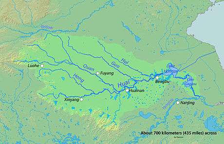 Map showing the Hui River and Huai River | |
Hui River (also pronounced as Kuai River), traditionally known as Huan River or Baohui River, was a major tributary of Huai River in northern China. Currently, it flows into the Huai-Hong New Canal[1] , a constructed flood-control waterway connecting Huaiyuan and Hongze Lake. The starting point of Hui River is the ancient Honggou Canal (鸿沟), which has a great historical significance because it was the border between territories controlled by Liu Bang and Xiang Yu during the Chu-Han Contention (206 - 202 BCE).[2] The river is mainly recharged by rainwater and groundwater. The river is heavily polluted by wastewater from nearby towns.
References
This article is issued from
Wikipedia.
The text is licensed under Creative Commons - Attribution - Sharealike.
Additional terms may apply for the media files.